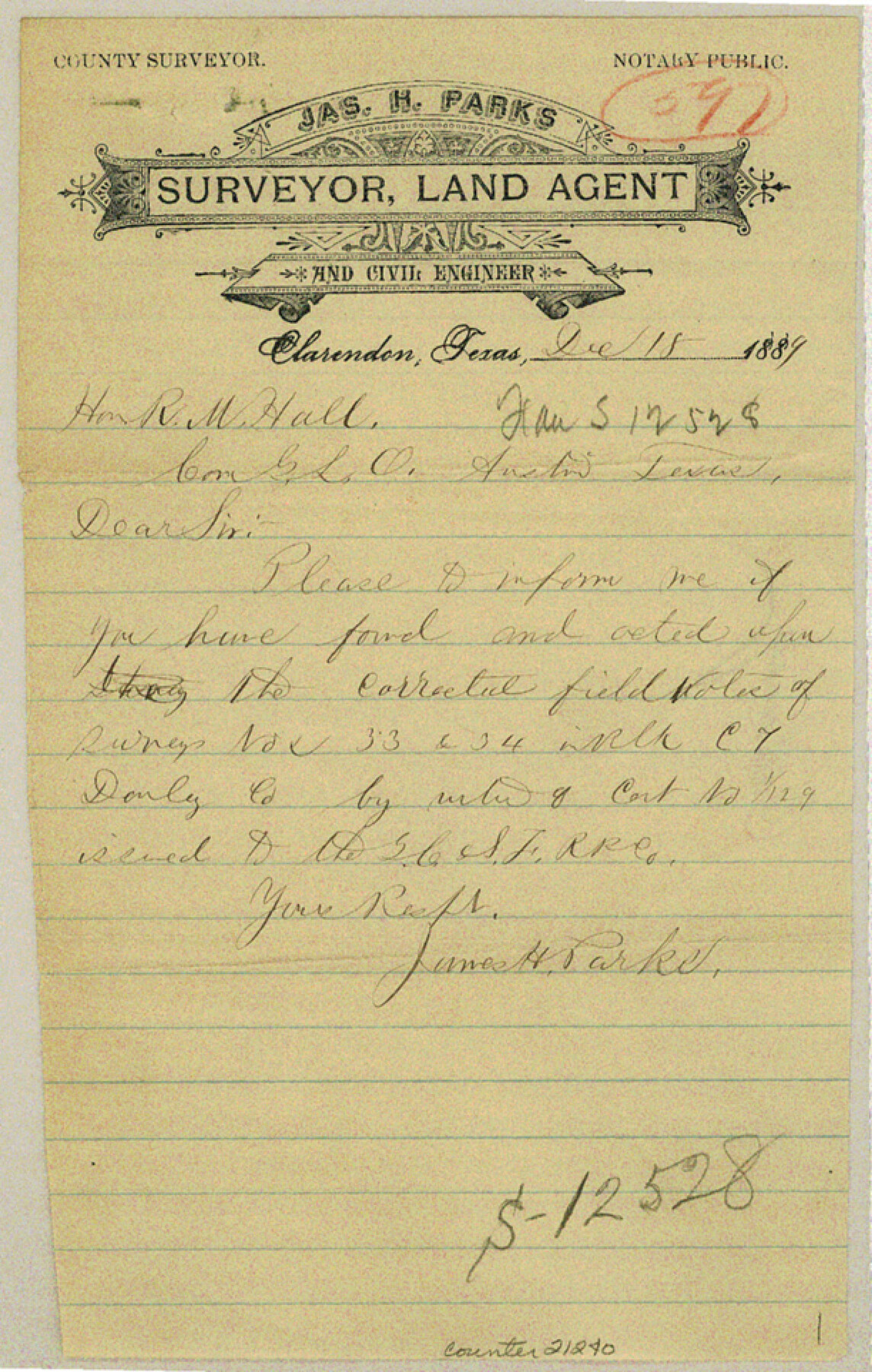
Donley County Sketch File 10
[Corrected field notes of surveys 33 and 34, Block C7, H. & T. C. RR. Co.]
-
Map/Doc
21240
-
Collection
General Map Collection
-
Object Dates
1889/12/18 (Creation Date)
1888/7/14 (Survey Date)
-
People and Organizations
James H. Parks (Surveyor/Engineer)
Wm. H. Oliver (Chainman)
Arthur Stanton (Chainman)
-
Counties
Donley
-
Subjects
Surveying Sketch File
-
Height x Width
9.6 x 6.1 inches
24.4 x 15.5 cm
-
Medium
multi-page, multi-format
-
Scale
1:4000
-
Features
Barton Creek
Salt Fork of Red River
Turkey Creek
Part of: General Map Collection
Jasper County Working Sketch 6

Print $20.00
- Digital $50.00
Jasper County Working Sketch 6
1914
Size 15.9 x 11.3 inches
Map/Doc 66468
Wichita County

Print $20.00
- Digital $50.00
Wichita County
1971
Size 35.8 x 37.7 inches
Map/Doc 77457
Angelina River, Mud Creek, Sheet 2

Print $4.00
- Digital $50.00
Angelina River, Mud Creek, Sheet 2
1937
Size 26.4 x 18.9 inches
Map/Doc 65076
Hays County Working Sketch 12

Print $20.00
- Digital $50.00
Hays County Working Sketch 12
1950
Size 22.8 x 24.3 inches
Map/Doc 66086
El Paso County Rolled Sketch 23

Print $20.00
- Digital $50.00
El Paso County Rolled Sketch 23
1888
Size 46.2 x 38.1 inches
Map/Doc 8856
McLennan County Sketch File 4

Print $4.00
- Digital $50.00
McLennan County Sketch File 4
1852
Size 12.7 x 8.2 inches
Map/Doc 31235
Flight Mission No. DAG-23K, Frame 17, Matagorda County

Print $20.00
- Digital $50.00
Flight Mission No. DAG-23K, Frame 17, Matagorda County
1953
Size 18.5 x 22.2 inches
Map/Doc 86479
Mitchell County

Print $20.00
- Digital $50.00
Mitchell County
1889
Size 44.3 x 37.8 inches
Map/Doc 66935
Walker County Working Sketch 6

Print $20.00
- Digital $50.00
Walker County Working Sketch 6
1935
Size 30.8 x 40.6 inches
Map/Doc 72286
Austin Map and Street Guide [Recto]
![94162, Austin Map and Street Guide [Recto], General Map Collection](https://historictexasmaps.com/wmedia_w700/maps/94162.tif.jpg)
Austin Map and Street Guide [Recto]
1976
Size 35.4 x 22.7 inches
Map/Doc 94162
Roberts County Working Sketch 4

Print $20.00
- Digital $50.00
Roberts County Working Sketch 4
1945
Size 37.1 x 32.8 inches
Map/Doc 63530
Howard County Sketch File 14

Print $8.00
- Digital $50.00
Howard County Sketch File 14
1940
Size 11.3 x 8.8 inches
Map/Doc 26871
You may also like
Texas, Corpus Christi Bay, Red Fish Bay to Nueces Bay

Print $40.00
- Digital $50.00
Texas, Corpus Christi Bay, Red Fish Bay to Nueces Bay
1934
Size 31.8 x 48.3 inches
Map/Doc 73459
Terrell County Working Sketch 42

Print $20.00
- Digital $50.00
Terrell County Working Sketch 42
1957
Size 34.4 x 34.4 inches
Map/Doc 62135
Map of Menard County
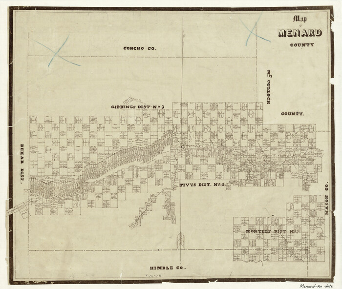
Print $20.00
- Digital $50.00
Map of Menard County
1871
Size 18.2 x 21.6 inches
Map/Doc 3873
Hardeman County Sketch File 1

Print $20.00
- Digital $50.00
Hardeman County Sketch File 1
Size 31.0 x 45.7 inches
Map/Doc 10477
Gaines County Rolled Sketch 17

Print $20.00
- Digital $50.00
Gaines County Rolled Sketch 17
1940
Size 24.5 x 17.8 inches
Map/Doc 5934
La Salle County Sketch File 3

Print $44.00
- Digital $50.00
La Salle County Sketch File 3
1875
Size 15.8 x 29.6 inches
Map/Doc 11978
Map of Fort Bend Co.

Print $20.00
- Digital $50.00
Map of Fort Bend Co.
1898
Size 45.3 x 41.6 inches
Map/Doc 4949
Padre Island National Seashore, Texas - Dependent Resurvey

Print $4.00
- Digital $50.00
Padre Island National Seashore, Texas - Dependent Resurvey
2001
Size 18.5 x 24.2 inches
Map/Doc 60547
Dickens County Sketch File 16

Print $4.00
- Digital $50.00
Dickens County Sketch File 16
Size 7.4 x 11.1 inches
Map/Doc 20975
Edwards County Sketch File 10b

Print $20.00
- Digital $50.00
Edwards County Sketch File 10b
1903
Size 17.0 x 18.9 inches
Map/Doc 11423
Galveston Bay & Texas Land Company Scrip No. 6086

Print $20.00
- Digital $50.00
Galveston Bay & Texas Land Company Scrip No. 6086
1830
Size 12.7 x 8.2 inches
Map/Doc 96568
The Republic County of Nacogdoches. February 1, 1842

Print $20.00
The Republic County of Nacogdoches. February 1, 1842
2020
Size 15.9 x 21.8 inches
Map/Doc 96247