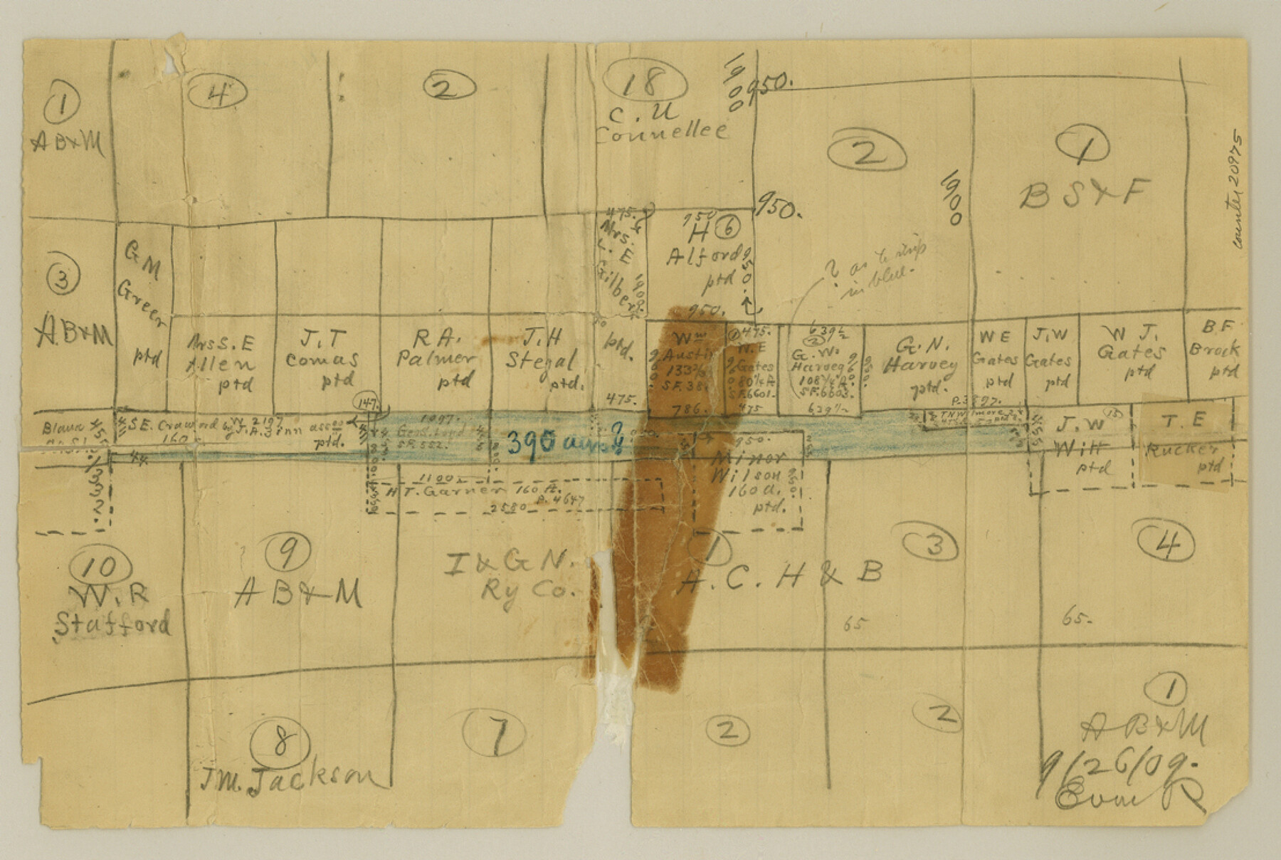
Dickens County Sketch File 16
[Office sketch showing G. W. Harvey survey and vacancy south]
-
Map/Doc
20975
-
Collection
General Map Collection
-
Object Dates
1909/9/26 (File Date)
Cr/9126/1909
-
People and Organizations
E. von Rosenberg (Draftsman)
G.W. Harvey (Surveyor/Engineer)
-
Counties
Dickens
-
Subjects
Surveying Sketch File
-
Height x Width
7.4 x 11.1 inches
18.8 x 28.2 cm
-
Medium
paper, manuscript
Part of: General Map Collection

Jasper County

Print $40.00
- Digital $50.00
Jasper County
1898
Size 64.2 x 35.6 inches
Map/Doc 78413
Concho County Sketch File 1

Print $5.00
- Digital $50.00
Concho County Sketch File 1
1856
Size 5.0 x 6.6 inches
Map/Doc 19121
Morris County Rolled Sketch 2A

Print $20.00
- Digital $50.00
Morris County Rolled Sketch 2A
Size 36.2 x 19.3 inches
Map/Doc 10282
Grundriss von Neu-Orleans nach den manuscripten in dem schatze der karten der marine

Print $20.00
- Digital $50.00
Grundriss von Neu-Orleans nach den manuscripten in dem schatze der karten der marine
1744
Size 9.6 x 14.1 inches
Map/Doc 94109
Jasper County Sketch File 29

Print $20.00
- Digital $50.00
Jasper County Sketch File 29
1947
Size 21.0 x 24.8 inches
Map/Doc 11851
McMullen County Sketch File 45

Print $10.00
- Digital $50.00
McMullen County Sketch File 45
1943
Size 14.2 x 8.9 inches
Map/Doc 31429
Bexar County Sketch File 50

Print $40.00
- Digital $50.00
Bexar County Sketch File 50
1874
Size 22.5 x 18.2 inches
Map/Doc 10926
Montgomery County Rolled Sketch 19A

Print $40.00
- Digital $50.00
Montgomery County Rolled Sketch 19A
1933
Size 53.4 x 35.4 inches
Map/Doc 9530
Andrews County Rolled Sketch 39

Print $20.00
- Digital $50.00
Andrews County Rolled Sketch 39
1979
Size 43.4 x 44.3 inches
Map/Doc 8401
Rand McNally Standard Map of Texas

Rand McNally Standard Map of Texas
1930
Size 34.6 x 28.0 inches
Map/Doc 2147
United States - Gulf Coast - Galveston to Rio Grande

Print $20.00
- Digital $50.00
United States - Gulf Coast - Galveston to Rio Grande
1919
Size 26.9 x 18.2 inches
Map/Doc 72743
You may also like
The Land Offices. No. 7, Milam, December 22, 1836

Print $20.00
The Land Offices. No. 7, Milam, December 22, 1836
2020
Size 23.9 x 21.7 inches
Map/Doc 96420
Pecos County Working Sketch 37

Print $20.00
- Digital $50.00
Pecos County Working Sketch 37
1939
Size 30.0 x 43.0 inches
Map/Doc 71509
Val Verde County Working Sketch 33

Print $20.00
- Digital $50.00
Val Verde County Working Sketch 33
1938
Size 24.4 x 30.7 inches
Map/Doc 72168
Sutton County Working Sketch 41

Print $20.00
- Digital $50.00
Sutton County Working Sketch 41
1950
Size 22.4 x 33.8 inches
Map/Doc 62384
State Map of Kansas Showing Productive Geological Formation of Each Oil Field

Print $20.00
- Digital $50.00
State Map of Kansas Showing Productive Geological Formation of Each Oil Field
1937
Size 45.5 x 29.8 inches
Map/Doc 92043

General Highway Map, Hidalgo County, Texas

Print $20.00
General Highway Map, Hidalgo County, Texas
1940
Size 18.4 x 24.7 inches
Map/Doc 79127
Bosque County Sketch File 14

Print $22.00
- Digital $50.00
Bosque County Sketch File 14
1863
Size 12.2 x 7.6 inches
Map/Doc 14763
Reeves County Rolled Sketch 24

Print $20.00
- Digital $50.00
Reeves County Rolled Sketch 24
1982
Size 37.2 x 24.9 inches
Map/Doc 7493
Map of Lockhart, Caldwell Co., Texas

Print $20.00
- Digital $50.00
Map of Lockhart, Caldwell Co., Texas
1907
Size 30.5 x 38.9 inches
Map/Doc 4461
Runnels County Rolled Sketch 54

Print $20.00
- Digital $50.00
Runnels County Rolled Sketch 54
Size 11.5 x 18.2 inches
Map/Doc 82576
Smith County Rolled Sketch 6B

Print $40.00
- Digital $50.00
Smith County Rolled Sketch 6B
1949
Size 91.7 x 38.5 inches
Map/Doc 10700