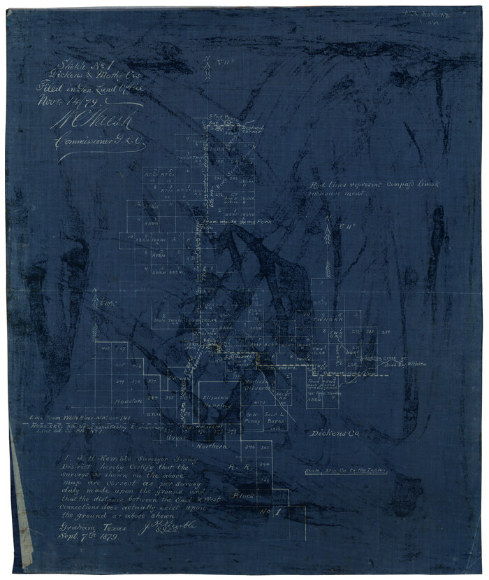
Sketch No. 1, Dickens & Motley Cos.
Print $20.00
- Digital $50.00
Sketch No. 1, Dickens & Motley Cos.
1879
Size: 17.9 x 15.5 inches
10761
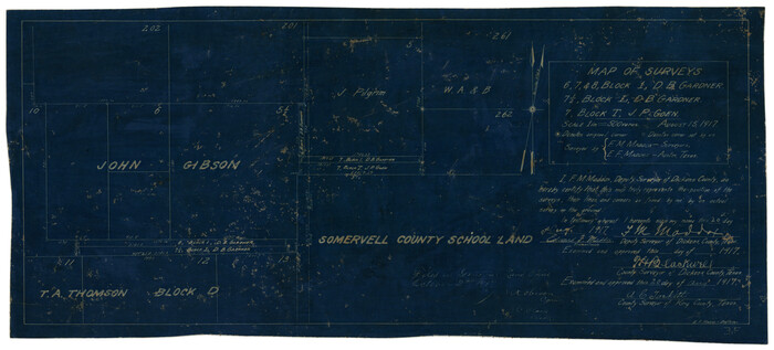
Map of Surveys 6, 7, & 8, Block 1, D.B. Gardner 7 1/2, Block L, D.B. Gardner 7, Block T, J.P. Goen
Print $20.00
- Digital $50.00
Map of Surveys 6, 7, & 8, Block 1, D.B. Gardner 7 1/2, Block L, D.B. Gardner 7, Block T, J.P. Goen
1917
Size: 11.0 x 22.6 inches
10762
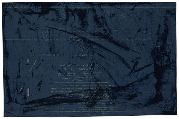
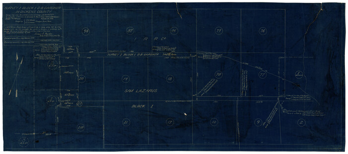
Map of Survey 8, Block 1, D.B. Gardner
Print $20.00
- Digital $50.00
Map of Survey 8, Block 1, D.B. Gardner
1915
Size: 13.0 x 18.8 inches
10763
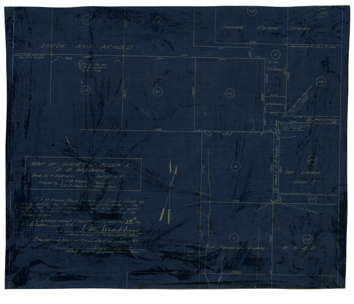
Map of Survey 10, Block 1, D.B. Gardner
Print $20.00
- Digital $50.00
Map of Survey 10, Block 1, D.B. Gardner
1915
Size: 16.1 x 18.7 inches
10764
Sketch of Survey 3, Block 1 in Dickens and King Counties

Print $20.00
- Digital $50.00
Sketch of Survey 3, Block 1 in Dickens and King Counties
1914
Size: 10.0 x 27.5 inches
10765
Sketch of Survey 3, Block 1 in Dickens and King Counties
Print $20.00
- Digital $50.00
Sketch of Survey 3, Block 1 in Dickens and King Counties
1914
Size: 10.8 x 28.2 inches
10766
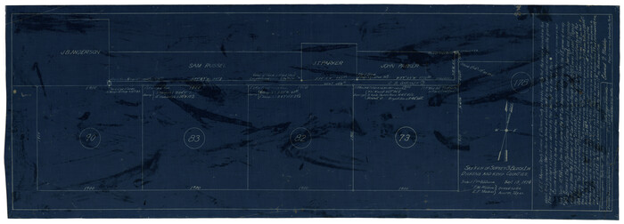
Survey 1, Block 1, D.B. Gardner in Dickens County
Print $20.00
- Digital $50.00
Survey 1, Block 1, D.B. Gardner in Dickens County
1914
Size: 14.9 x 30.4 inches
10767
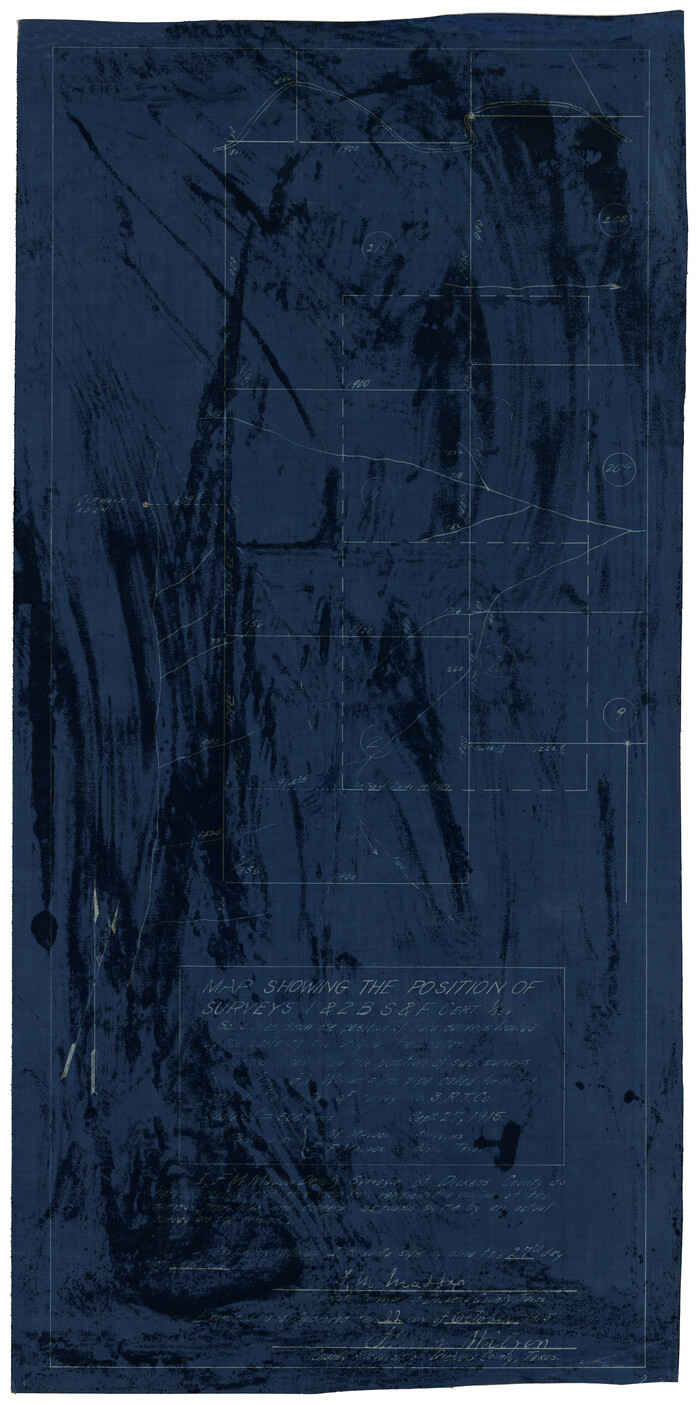
Map Showing the position of surveys 1 & 2, B.S. & F. Cert 1/356
Print $20.00
- Digital $50.00
Map Showing the position of surveys 1 & 2, B.S. & F. Cert 1/356
1915
Size: 22.0 x 11.1 inches
10768
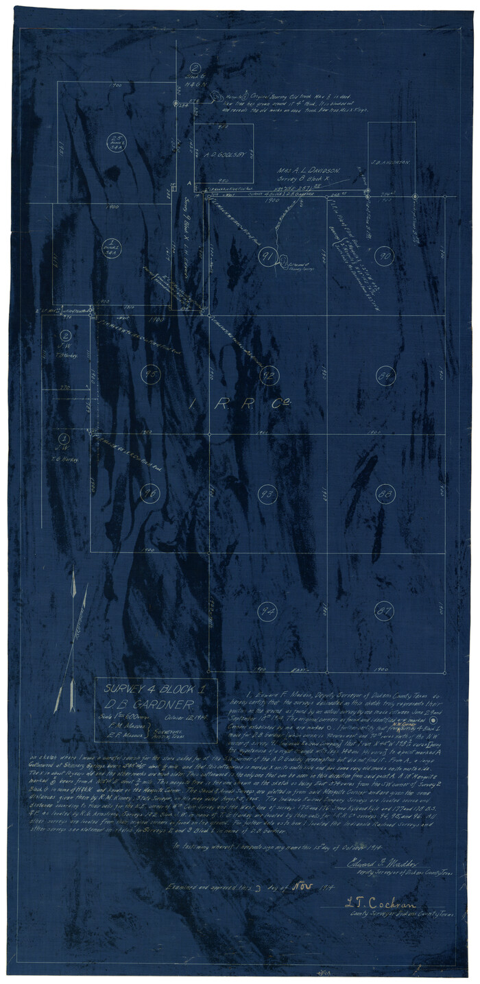
Survey 4, Block 1, D.B. Gardner
Print $20.00
- Digital $50.00
Survey 4, Block 1, D.B. Gardner
1914
Size: 26.6 x 13.7 inches
10769
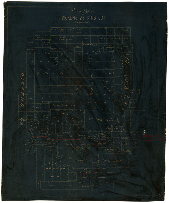
Working Sketch in Dickens & King Cos.
Print $20.00
- Digital $50.00
Working Sketch in Dickens & King Cos.
Size: 24.4 x 20.4 inches
10770
Working Sketch in Dickens and Crosby Cos.

Print $20.00
- Digital $50.00
Working Sketch in Dickens and Crosby Cos.
1910
Size: 36.1 x 24.8 inches
10771
Map of Block 1, H. & G. N. R. R. Co., Dickens and Kent Counties Texas
Print $20.00
- Digital $50.00
Map of Block 1, H. & G. N. R. R. Co., Dickens and Kent Counties Texas
1908
Size: 32.0 x 24.2 inches
10780
Crosby County Sketch File 1b

Print $20.00
- Digital $50.00
Crosby County Sketch File 1b
Size: 18.0 x 14.5 inches
11244
Crosby County Sketch File 31

Print $20.00
- Digital $50.00
Crosby County Sketch File 31
Size: 35.0 x 14.0 inches
11257
Dickens County Sketch File 1

Print $20.00
- Digital $50.00
Dickens County Sketch File 1
1879
Size: 18.2 x 15.5 inches
11315
Dickens County Sketch File 2

Print $20.00
- Digital $50.00
Dickens County Sketch File 2
1913
Size: 22.0 x 32.3 inches
11316
Dickens County Sketch File 4

Print $20.00
- Digital $50.00
Dickens County Sketch File 4
Size: 21.2 x 27.1 inches
11317
Dickens County Sketch File 9

Print $4.00
- Digital $50.00
Dickens County Sketch File 9
Size: 21.6 x 20.9 inches
11319
Dickens County Sketch File 14

Print $20.00
- Digital $50.00
Dickens County Sketch File 14
Size: 19.6 x 16.6 inches
11320
Dickens County Sketch File 14a

Print $20.00
- Digital $50.00
Dickens County Sketch File 14a
Size: 18.2 x 16.5 inches
11321
Dickens County Sketch File 18a

Print $20.00
- Digital $50.00
Dickens County Sketch File 18a
Size: 17.6 x 19.4 inches
11322
Dickens County Sketch File 18aa

Print $20.00
- Digital $50.00
Dickens County Sketch File 18aa
Size: 17.2 x 18.2 inches
11323
Dickens County Sketch File 21

Print $20.00
- Digital $50.00
Dickens County Sketch File 21
1911
Size: 16.0 x 12.8 inches
11324
Dickens County Sketch File 24

Print $20.00
- Digital $50.00
Dickens County Sketch File 24
1914
Size: 20.0 x 16.1 inches
11325
Dickens County Sketch File 25

Print $20.00
- Digital $50.00
Dickens County Sketch File 25
1914
Size: 19.2 x 14.4 inches
11326
Dickens County Sketch File 31

Print $20.00
- Digital $50.00
Dickens County Sketch File 31
Size: 22.3 x 9.5 inches
11327
Dickens County Sketch File 32

Print $20.00
- Digital $50.00
Dickens County Sketch File 32
Size: 32.8 x 30.6 inches
11328
Dickens County Sketch File D

Print $20.00
- Digital $50.00
Dickens County Sketch File D
1883
Size: 15.7 x 14.8 inches
11330
Dickens County Sketch File G1

Print $20.00
- Digital $50.00
Dickens County Sketch File G1
1914
Size: 22.0 x 18.0 inches
11332
Dickens County Sketch File GW1

Print $20.00
- Digital $50.00
Dickens County Sketch File GW1
1911
Size: 31.5 x 24.4 inches
11334
Sketch No. 1, Dickens & Motley Cos.
Print $20.00
- Digital $50.00
Sketch No. 1, Dickens & Motley Cos.
1879
-
Size
17.9 x 15.5 inches
-
Map/Doc
10761
-
Creation Date
1879
Map of Surveys 6, 7, & 8, Block 1, D.B. Gardner 7 1/2, Block L, D.B. Gardner 7, Block T, J.P. Goen
Print $20.00
- Digital $50.00
Map of Surveys 6, 7, & 8, Block 1, D.B. Gardner 7 1/2, Block L, D.B. Gardner 7, Block T, J.P. Goen
1917
-
Size
11.0 x 22.6 inches
-
Map/Doc
10762
-
Creation Date
1917
Map of Survey 8, Block 1, D.B. Gardner
Print $20.00
- Digital $50.00
Map of Survey 8, Block 1, D.B. Gardner
1915
-
Size
13.0 x 18.8 inches
-
Map/Doc
10763
-
Creation Date
1915
Map of Survey 10, Block 1, D.B. Gardner
Print $20.00
- Digital $50.00
Map of Survey 10, Block 1, D.B. Gardner
1915
-
Size
16.1 x 18.7 inches
-
Map/Doc
10764
-
Creation Date
1915
Sketch of Survey 3, Block 1 in Dickens and King Counties
Print $20.00
- Digital $50.00
Sketch of Survey 3, Block 1 in Dickens and King Counties
1914
-
Size
10.0 x 27.5 inches
-
Map/Doc
10765
-
Creation Date
1914
Sketch of Survey 3, Block 1 in Dickens and King Counties
Print $20.00
- Digital $50.00
Sketch of Survey 3, Block 1 in Dickens and King Counties
1914
-
Size
10.8 x 28.2 inches
-
Map/Doc
10766
-
Creation Date
1914
Survey 1, Block 1, D.B. Gardner in Dickens County
Print $20.00
- Digital $50.00
Survey 1, Block 1, D.B. Gardner in Dickens County
1914
-
Size
14.9 x 30.4 inches
-
Map/Doc
10767
-
Creation Date
1914
Map Showing the position of surveys 1 & 2, B.S. & F. Cert 1/356
Print $20.00
- Digital $50.00
Map Showing the position of surveys 1 & 2, B.S. & F. Cert 1/356
1915
-
Size
22.0 x 11.1 inches
-
Map/Doc
10768
-
Creation Date
1915
Survey 4, Block 1, D.B. Gardner
Print $20.00
- Digital $50.00
Survey 4, Block 1, D.B. Gardner
1914
-
Size
26.6 x 13.7 inches
-
Map/Doc
10769
-
Creation Date
1914
Working Sketch in Dickens & King Cos.
Print $20.00
- Digital $50.00
Working Sketch in Dickens & King Cos.
-
Size
24.4 x 20.4 inches
-
Map/Doc
10770
Working Sketch in Dickens and Crosby Cos.
Print $20.00
- Digital $50.00
Working Sketch in Dickens and Crosby Cos.
1910
-
Size
36.1 x 24.8 inches
-
Map/Doc
10771
-
Creation Date
1910
Map of Block 1, H. & G. N. R. R. Co., Dickens and Kent Counties Texas
Print $20.00
- Digital $50.00
Map of Block 1, H. & G. N. R. R. Co., Dickens and Kent Counties Texas
1908
-
Size
32.0 x 24.2 inches
-
Map/Doc
10780
-
Creation Date
1908
Crosby County Sketch File 1b
Print $20.00
- Digital $50.00
Crosby County Sketch File 1b
-
Size
18.0 x 14.5 inches
-
Map/Doc
11244
Crosby County Sketch File 31
Print $20.00
- Digital $50.00
Crosby County Sketch File 31
-
Size
35.0 x 14.0 inches
-
Map/Doc
11257
Dickens County Sketch File 1
Print $20.00
- Digital $50.00
Dickens County Sketch File 1
1879
-
Size
18.2 x 15.5 inches
-
Map/Doc
11315
-
Creation Date
1879
Dickens County Sketch File 2
Print $20.00
- Digital $50.00
Dickens County Sketch File 2
1913
-
Size
22.0 x 32.3 inches
-
Map/Doc
11316
-
Creation Date
1913
Dickens County Sketch File 4
Print $20.00
- Digital $50.00
Dickens County Sketch File 4
-
Size
21.2 x 27.1 inches
-
Map/Doc
11317
Dickens County Sketch File 9
Print $4.00
- Digital $50.00
Dickens County Sketch File 9
-
Size
21.6 x 20.9 inches
-
Map/Doc
11319
Dickens County Sketch File 14
Print $20.00
- Digital $50.00
Dickens County Sketch File 14
-
Size
19.6 x 16.6 inches
-
Map/Doc
11320
Dickens County Sketch File 14a
Print $20.00
- Digital $50.00
Dickens County Sketch File 14a
-
Size
18.2 x 16.5 inches
-
Map/Doc
11321
Dickens County Sketch File 18a
Print $20.00
- Digital $50.00
Dickens County Sketch File 18a
-
Size
17.6 x 19.4 inches
-
Map/Doc
11322
Dickens County Sketch File 18aa
Print $20.00
- Digital $50.00
Dickens County Sketch File 18aa
-
Size
17.2 x 18.2 inches
-
Map/Doc
11323
Dickens County Sketch File 21
Print $20.00
- Digital $50.00
Dickens County Sketch File 21
1911
-
Size
16.0 x 12.8 inches
-
Map/Doc
11324
-
Creation Date
1911
Dickens County Sketch File 24
Print $20.00
- Digital $50.00
Dickens County Sketch File 24
1914
-
Size
20.0 x 16.1 inches
-
Map/Doc
11325
-
Creation Date
1914
Dickens County Sketch File 25
Print $20.00
- Digital $50.00
Dickens County Sketch File 25
1914
-
Size
19.2 x 14.4 inches
-
Map/Doc
11326
-
Creation Date
1914
Dickens County Sketch File 31
Print $20.00
- Digital $50.00
Dickens County Sketch File 31
-
Size
22.3 x 9.5 inches
-
Map/Doc
11327
Dickens County Sketch File 32
Print $20.00
- Digital $50.00
Dickens County Sketch File 32
-
Size
32.8 x 30.6 inches
-
Map/Doc
11328
Dickens County Sketch File D
Print $20.00
- Digital $50.00
Dickens County Sketch File D
1883
-
Size
15.7 x 14.8 inches
-
Map/Doc
11330
-
Creation Date
1883
Dickens County Sketch File G1
Print $20.00
- Digital $50.00
Dickens County Sketch File G1
1914
-
Size
22.0 x 18.0 inches
-
Map/Doc
11332
-
Creation Date
1914
Dickens County Sketch File GW1
Print $20.00
- Digital $50.00
Dickens County Sketch File GW1
1911
-
Size
31.5 x 24.4 inches
-
Map/Doc
11334
-
Creation Date
1911