Dickens County Sketch File GW1
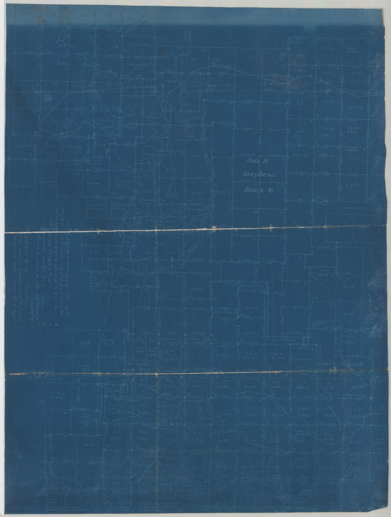
Resurvey of "JMS" Ranch in Dickens, King & Motley Cos.
-
Map/Doc
11334
-
Collection
General Map Collection
-
Object Dates
1911 (Creation Date)
1913 (Survey Date)
-
People and Organizations
George M. Williams (Surveyor/Engineer)
-
Counties
Dickens Motley Cottle King Dickens
-
Subjects
Surveying Sketch File
-
Height x Width
31.5 x 24.4 inches
80.0 x 62.0 cm
-
Medium
blueprint/diazo
-
Features
QA&P
Bluff Creek
S.M.S. Tongue River Ranch
China Canon
Tongue River
Thief Hollow Creek
Horse Canon
Willow Branch Canon
Water Canon
North Wichita River
West Creek
Part of: General Map Collection
Map of Cherokee County

Print $20.00
- Digital $50.00
Map of Cherokee County
1848
Size 27.1 x 20.6 inches
Map/Doc 3390
Erath County Working Sketch 35

Print $20.00
- Digital $50.00
Erath County Working Sketch 35
1973
Size 24.8 x 28.4 inches
Map/Doc 69116
Webb County Working Sketch 43

Print $20.00
- Digital $50.00
Webb County Working Sketch 43
1942
Size 18.4 x 27.5 inches
Map/Doc 72408
San Jacinto River, Buff Lake Sheet 1/Caney Creek

Print $20.00
- Digital $50.00
San Jacinto River, Buff Lake Sheet 1/Caney Creek
1937
Size 18.7 x 37.6 inches
Map/Doc 65147
Flight Mission No. DIX-10P, Frame 146, Aransas County

Print $20.00
- Digital $50.00
Flight Mission No. DIX-10P, Frame 146, Aransas County
1956
Size 18.6 x 22.4 inches
Map/Doc 83948
Foard County Working Sketch 6

Print $20.00
- Digital $50.00
Foard County Working Sketch 6
1944
Size 43.4 x 31.4 inches
Map/Doc 69197
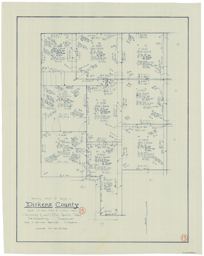
Dickens County Working Sketch 13
Print $20.00
- Digital $50.00
Dickens County Working Sketch 13
1981
Size 26.8 x 21.4 inches
Map/Doc 68661
Reagan County Working Sketch 46a

Print $20.00
- Digital $50.00
Reagan County Working Sketch 46a
1970
Size 34.5 x 30.4 inches
Map/Doc 71888
Culberson County Working Sketch 84

Print $20.00
- Digital $50.00
Culberson County Working Sketch 84
1980
Size 43.5 x 42.9 inches
Map/Doc 68538
Hays County Sketch File 2

Print $4.00
- Digital $50.00
Hays County Sketch File 2
1846
Size 6.3 x 8.1 inches
Map/Doc 26200
Runnels County Sketch File 3

Print $4.00
Runnels County Sketch File 3
1871
Size 13.0 x 8.1 inches
Map/Doc 35432
McMullen County Sketch File 3

Print $4.00
- Digital $50.00
McMullen County Sketch File 3
Size 8.2 x 6.5 inches
Map/Doc 31339
You may also like
Cooke County Sketch File 29

Print $16.00
- Digital $50.00
Cooke County Sketch File 29
1873
Size 8.2 x 11.0 inches
Map/Doc 19283
Brewster County Rolled Sketch 93

Print $20.00
- Digital $50.00
Brewster County Rolled Sketch 93
1935
Size 24.1 x 43.1 inches
Map/Doc 5251
Matagorda Bay and Approaches

Print $20.00
- Digital $50.00
Matagorda Bay and Approaches
1972
Size 34.8 x 44.8 inches
Map/Doc 73384
Map of Parker County

Print $20.00
- Digital $50.00
Map of Parker County
1871
Size 20.9 x 18.4 inches
Map/Doc 3942
Falls County Sketch File 32

Print $20.00
- Digital $50.00
Falls County Sketch File 32
Size 36.3 x 24.7 inches
Map/Doc 11468
Working Sketch of Surveys in Garza Co. About 12 Miles N. from Post City

Print $40.00
- Digital $50.00
Working Sketch of Surveys in Garza Co. About 12 Miles N. from Post City
1950
Size 48.5 x 37.4 inches
Map/Doc 89872
Briscoe County Sketch File 13

Print $168.00
- Digital $50.00
Briscoe County Sketch File 13
1982
Size 11.2 x 8.7 inches
Map/Doc 16428
Coke County Working Sketch 16

Print $20.00
- Digital $50.00
Coke County Working Sketch 16
1948
Size 23.4 x 24.5 inches
Map/Doc 68053
Aransas County Sketch File 25

Print $20.00
- Digital $50.00
Aransas County Sketch File 25
Size 17.0 x 17.5 inches
Map/Doc 13218
Old Miscellaneous File 38

Print $40.00
- Digital $50.00
Old Miscellaneous File 38
Size 58.2 x 33.7 inches
Map/Doc 75283
Flight Mission No. DCL-7C, Frame 137, Kenedy County

Print $20.00
- Digital $50.00
Flight Mission No. DCL-7C, Frame 137, Kenedy County
1943
Size 15.4 x 15.3 inches
Map/Doc 86094
Current Miscellaneous File 19

Print $10.00
- Digital $50.00
Current Miscellaneous File 19
Size 11.8 x 8.8 inches
Map/Doc 73849