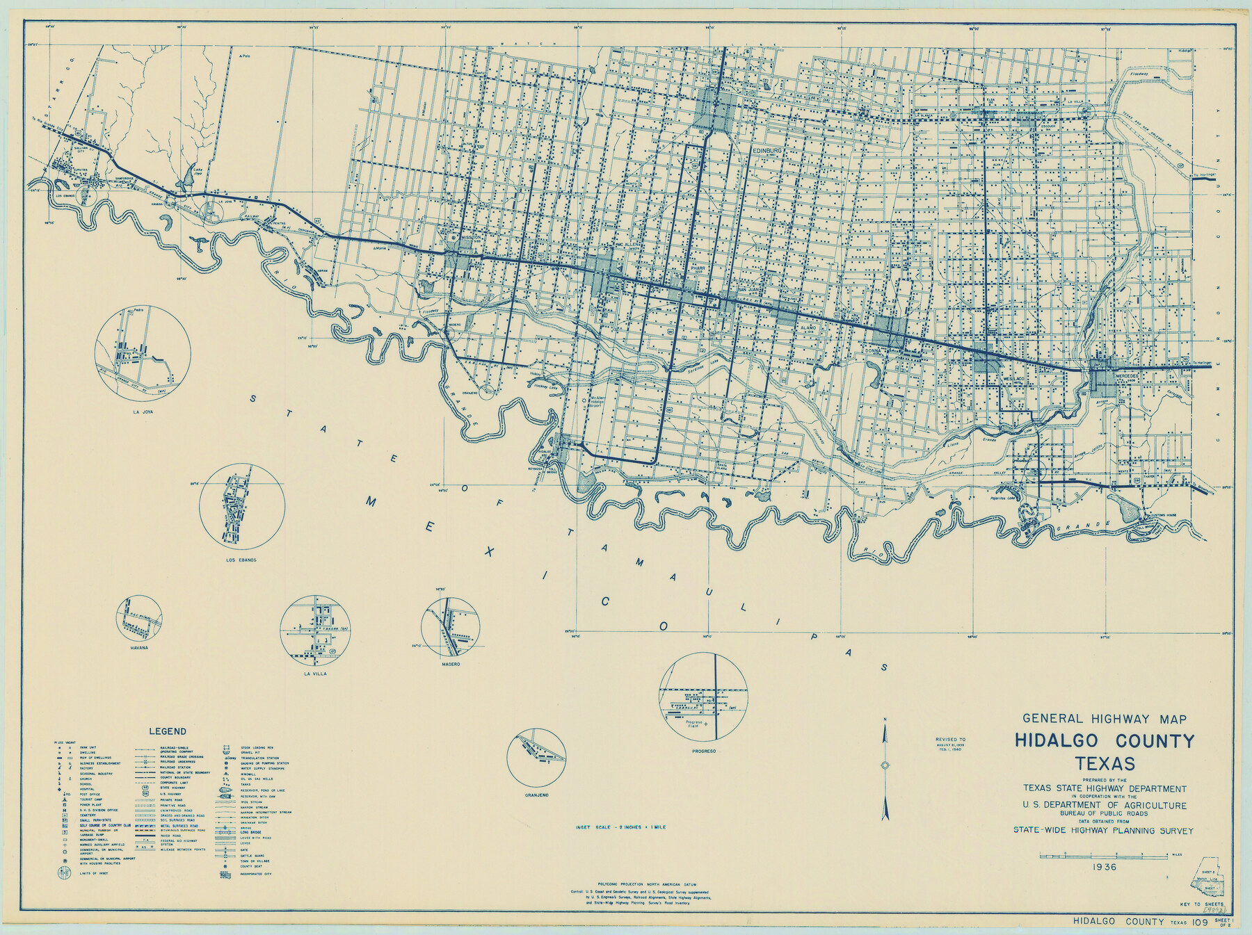
General Highway Map, Hidalgo County, Texas
-
Map/Doc
79127
-
Collection
Texas State Library and Archives
-
Object Dates
1940 (Creation Date)
-
People and Organizations
Texas State Highway Department (Publisher)
-
Counties
Hidalgo
-
Subjects
County
-
Height x Width
18.4 x 24.7 inches
46.7 x 62.7 cm
-
Comments
Prints available courtesy of the Texas State Library and Archives.
More info can be found here: TSLAC Map 04892
Part of: Texas State Library and Archives
Corpus Christi is the Sportsman's Paradise

Print $20.00
Corpus Christi is the Sportsman's Paradise
1942
Size 26.8 x 16.4 inches
Map/Doc 79331
General Highway Map. Detail of Cities and Towns in Hale County, Texas [Plainview and vicinity]
![79109, General Highway Map. Detail of Cities and Towns in Hale County, Texas [Plainview and vicinity], Texas State Library and Archives](https://historictexasmaps.com/wmedia_w700/maps/79109.tif.jpg)
Print $20.00
General Highway Map. Detail of Cities and Towns in Hale County, Texas [Plainview and vicinity]
1940
Size 25.0 x 18.5 inches
Map/Doc 79109
General Highway Map, Chambers County, Texas

Print $20.00
General Highway Map, Chambers County, Texas
1940
Size 18.4 x 25.3 inches
Map/Doc 79044
Topographic Map of Texas and Oklahoma Boundary, Fort Augur Area

Print $20.00
Topographic Map of Texas and Oklahoma Boundary, Fort Augur Area
1924
Size 32.3 x 33.8 inches
Map/Doc 79755
General Highway Map, San Jacinto County, Texas

Print $20.00
General Highway Map, San Jacinto County, Texas
1940
Size 24.9 x 18.4 inches
Map/Doc 79236
General Highway Map, Kerr County, Texas

Print $20.00
General Highway Map, Kerr County, Texas
1961
Size 24.8 x 18.2 inches
Map/Doc 79551
Stanford's Map of the Seat of War in America

Print $40.00
Stanford's Map of the Seat of War in America
1861
Size 52.2 x 45.7 inches
Map/Doc 76231
General Highway Map, Loving County, Texas

Print $20.00
General Highway Map, Loving County, Texas
1961
Size 18.1 x 24.6 inches
Map/Doc 79577
General Highway Map, Dawson County, Texas

Print $20.00
General Highway Map, Dawson County, Texas
1961
Size 18.0 x 24.5 inches
Map/Doc 79436
Worley's Map of Greater Dallas

Print $20.00
Worley's Map of Greater Dallas
1905
Size 34.9 x 25.4 inches
Map/Doc 79319
General Highway Map, Taylor County, Texas

Print $20.00
General Highway Map, Taylor County, Texas
1940
Size 18.6 x 25.0 inches
Map/Doc 79254
General Highway Map. Detail of Cities and Towns in Falls County, Texas

Print $20.00
General Highway Map. Detail of Cities and Towns in Falls County, Texas
1961
Size 18.1 x 24.4 inches
Map/Doc 79463
You may also like
Hays County Working Sketch 13

Print $20.00
- Digital $50.00
Hays County Working Sketch 13
1952
Size 24.2 x 35.0 inches
Map/Doc 66087
Atascosa County Sketch File 7

Print $4.00
- Digital $50.00
Atascosa County Sketch File 7
Size 8.2 x 6.5 inches
Map/Doc 13756
Erath County Working Sketch 40

Print $20.00
- Digital $50.00
Erath County Working Sketch 40
1977
Size 26.2 x 14.9 inches
Map/Doc 69121
Flight Mission No. DAG-22K, Frame 81, Matagorda County

Print $20.00
- Digital $50.00
Flight Mission No. DAG-22K, Frame 81, Matagorda County
1953
Size 18.6 x 22.4 inches
Map/Doc 86465
Flight Mission No. DAG-18K, Frame 180, Matagorda County

Print $20.00
- Digital $50.00
Flight Mission No. DAG-18K, Frame 180, Matagorda County
1952
Size 18.6 x 22.3 inches
Map/Doc 86372
Culberson County Sketch File 31

Print $4.00
- Digital $50.00
Culberson County Sketch File 31
1951
Size 11.3 x 8.9 inches
Map/Doc 20283

Young Land District

Print $20.00
- Digital $50.00
Young Land District
1857
Size 21.7 x 29.7 inches
Map/Doc 1974
Atascosa County Sketch File 28

Print $40.00
- Digital $50.00
Atascosa County Sketch File 28
1878
Size 27.9 x 21.7 inches
Map/Doc 10862
Wichita County Rolled Sketch 15

Print $20.00
- Digital $50.00
Wichita County Rolled Sketch 15
Size 17.0 x 37.1 inches
Map/Doc 8252
Baylor County

Print $20.00
- Digital $50.00
Baylor County
1961
Size 40.6 x 33.0 inches
Map/Doc 77209
The Mexican Municipality of Gonzales. Proposed, No Date

Print $20.00
The Mexican Municipality of Gonzales. Proposed, No Date
2020
Size 20.4 x 21.7 inches
Map/Doc 96020