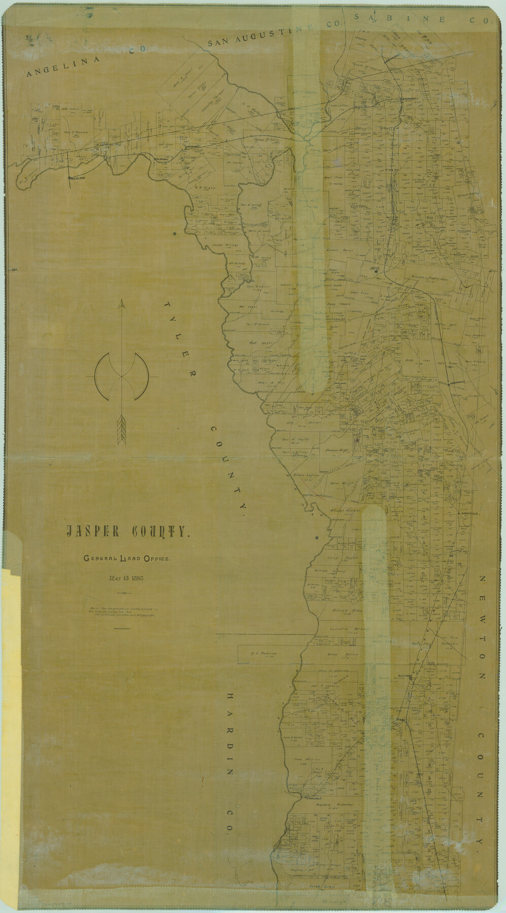
Jasper County
-
Map/Doc
78413
-
Collection
General Map Collection
-
Object Dates
1898/5/13 (Creation Date)
-
People and Organizations
Texas General Land Office (Publisher)
-
Counties
Jasper
-
Subjects
County
-
Height x Width
64.2 x 35.6 inches
163.1 x 90.4 cm
-
Comments
Help Save Texas History - Adopt Me!
-
Features
Frazier Creek
Robinson Creek
Roganville
Clare Creek
South Branch of Everett Creek
Big Creek
Wright Creek
Everett Creek
Trout Creek
Bogggy Creek
Kirbyville
Nichols Creek
Walnut Run
Bessmay
GB&KC
Buna
Mill Creek
Evadale
Ten Mile Creek
Four Mile Lake
Big Sandy Creek
Cole Bayou
Cut Off
B&GN
Rockland
Browndell
Bear Creek
Ayish Bayou
Turpentine
O&NW
GB&GN
RB&C
Tiger Creek
Beef Creek
Hog Creek
Aldridge
Brookland
Angelina River
Neches River
Four Mile Creek
Jasper
Indian Creek
Jordan Creek
Williams Creek
Spring Creek
Sandy Creek
Walnut Creek
Prairie Creek
Part of: General Map Collection

Borden County Boundary File 4

Print $2.00
- Digital $50.00
Borden County Boundary File 4
Size 13.3 x 8.3 inches
Map/Doc 50636
Flight Mission No. DAG-21K, Frame 133, Matagorda County

Print $20.00
- Digital $50.00
Flight Mission No. DAG-21K, Frame 133, Matagorda County
1952
Size 18.6 x 22.4 inches
Map/Doc 86459
Johnson County Working Sketch 10

Print $20.00
- Digital $50.00
Johnson County Working Sketch 10
1953
Size 26.2 x 37.1 inches
Map/Doc 66623
San Saba County Sketch File 7

Print $22.00
- Digital $50.00
San Saba County Sketch File 7
1883
Size 8.6 x 7.8 inches
Map/Doc 36417
[Surveys in the Travis District along the Colorado River]
![115, [Surveys in the Travis District along the Colorado River], General Map Collection](https://historictexasmaps.com/wmedia_w700/maps/115.tif.jpg)
Print $2.00
- Digital $50.00
[Surveys in the Travis District along the Colorado River]
1840
Size 8.0 x 10.2 inches
Map/Doc 115
Mills County Working Sketch 15

Print $20.00
- Digital $50.00
Mills County Working Sketch 15
1951
Size 38.4 x 41.6 inches
Map/Doc 71045
Map of Nacogdoches County

Print $40.00
- Digital $50.00
Map of Nacogdoches County
1839
Size 81.0 x 40.9 inches
Map/Doc 93374
Flight Mission No. DQN-4K, Frame 7, Calhoun County

Print $20.00
- Digital $50.00
Flight Mission No. DQN-4K, Frame 7, Calhoun County
1953
Size 18.5 x 22.2 inches
Map/Doc 84372
Nueces County Rolled Sketch 136

Print $40.00
- Digital $50.00
Nueces County Rolled Sketch 136
2006
Size 37.5 x 50.0 inches
Map/Doc 83556
Pecos County Working Sketch 22

Print $20.00
- Digital $50.00
Pecos County Working Sketch 22
1926
Size 14.3 x 23.5 inches
Map/Doc 71492
Glasscock County Working Sketch 7

Print $20.00
- Digital $50.00
Glasscock County Working Sketch 7
1952
Size 36.8 x 31.9 inches
Map/Doc 63180
You may also like
Montgomery County Working Sketch 72

Print $20.00
- Digital $50.00
Montgomery County Working Sketch 72
1979
Size 17.2 x 32.4 inches
Map/Doc 71179
Sketch for Blocks D6, D7, D8 situated in Val Verde County, Texas

Print $40.00
- Digital $50.00
Sketch for Blocks D6, D7, D8 situated in Val Verde County, Texas
1937
Size 100.1 x 40.0 inches
Map/Doc 93166
Flight Mission No. BRA-7M, Frame 189, Jefferson County

Print $20.00
- Digital $50.00
Flight Mission No. BRA-7M, Frame 189, Jefferson County
1953
Size 18.5 x 22.3 inches
Map/Doc 85557
Burleson County Sketch File 8

Print $6.00
- Digital $50.00
Burleson County Sketch File 8
Size 8.7 x 5.3 inches
Map/Doc 16654
[Block 37, Townships 1 and 2 North]
![91363, [Block 37, Townships 1 and 2 North], Twichell Survey Records](https://historictexasmaps.com/wmedia_w700/maps/91363-1.tif.jpg)
Print $20.00
- Digital $50.00
[Block 37, Townships 1 and 2 North]
Size 19.7 x 40.9 inches
Map/Doc 91363
Young County Sketch File 9a

Print $4.00
- Digital $50.00
Young County Sketch File 9a
1875
Size 12.9 x 8.3 inches
Map/Doc 40866
Falls County Sketch File 31

Print $4.00
- Digital $50.00
Falls County Sketch File 31
1881
Size 14.5 x 8.8 inches
Map/Doc 22439

Map of Wharton County

Print $20.00
- Digital $50.00
Map of Wharton County
1871
Size 22.0 x 22.9 inches
Map/Doc 4642

[Texas and Pacific Railway Company, Block 44, Township One South]
![89845, [Texas and Pacific Railway Company, Block 44, Township One South], Twichell Survey Records](https://historictexasmaps.com/wmedia_w700/maps/89845-1.tif.jpg)
Print $40.00
- Digital $50.00
[Texas and Pacific Railway Company, Block 44, Township One South]
Size 42.0 x 59.2 inches
Map/Doc 89845
Jefferson County Rolled Sketch 61A

Print $20.00
- Digital $50.00
Jefferson County Rolled Sketch 61A
1928
Size 27.2 x 40.4 inches
Map/Doc 6410