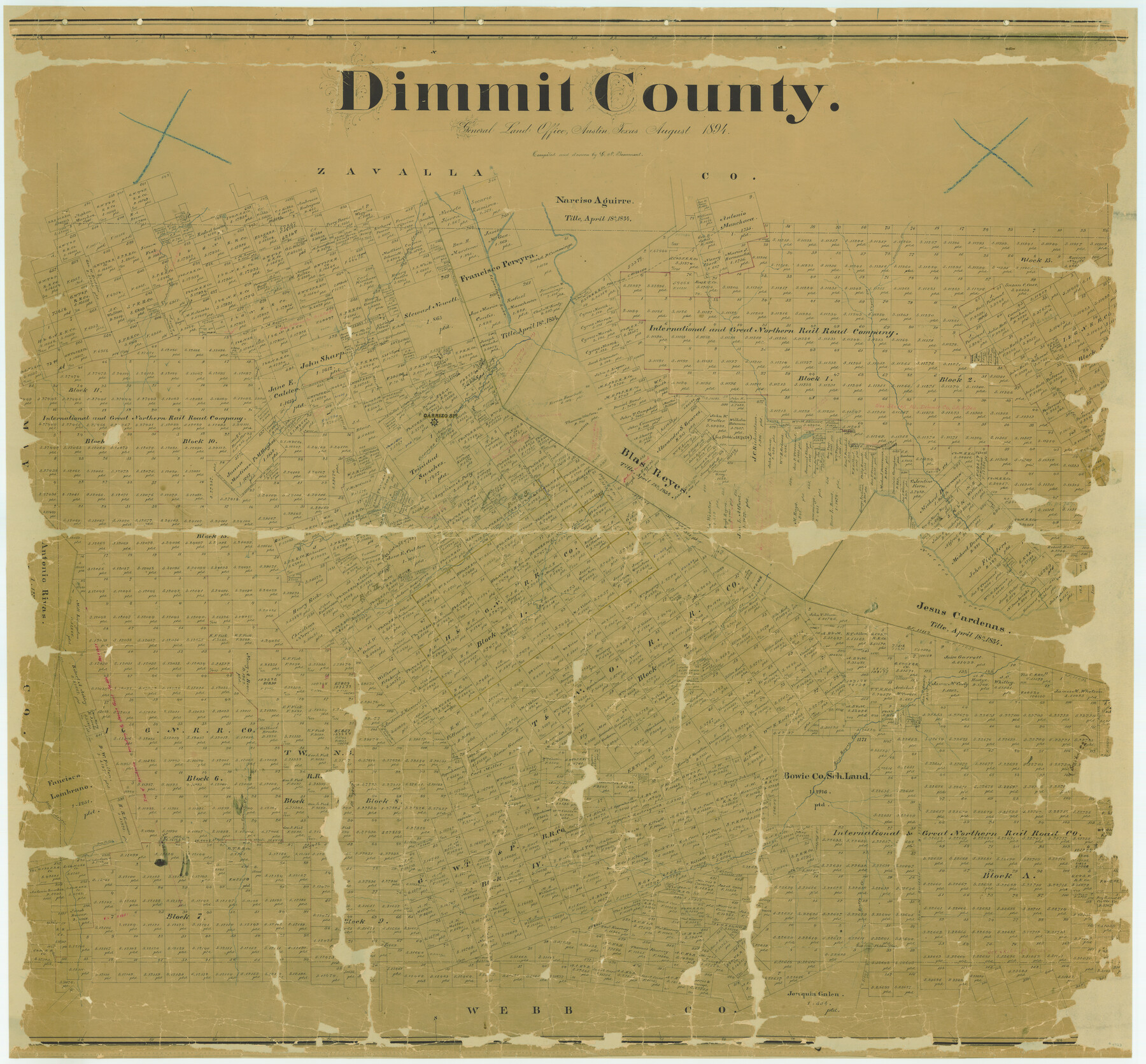
Dimmit County
-
Map/Doc
4723
-
Collection
General Map Collection
-
Object Dates
1894 (Creation Date)
-
People and Organizations
Texas General Land Office (Publisher)
G.N. Beaumont (Draftsman)
G.N. Beaumont (Compiler)
-
Counties
Dimmit
-
Subjects
County
-
Height x Width
41.7 x 44.9 inches
105.9 x 114.0 cm
-
Comments
Conservation funded in 2004 with donation from Union State Bank.
-
Features
Carrizo Creek
Los Piloncillos
Burro Creek
San Lorenzo Creek
San Pedro Creek
San Ambrosio Creek
San Rogue Creek
Apuracion Creek
Barroso Creek
El Moro Creek
Nueces River
West Fork of Carrizo Creek
Carrizo Springs
Anderson Creek
Negro Creek
Tortugas Creek
Presidio Crossing
Espio Creek
Espantoso Lake
Pena Creek
Pendencia Creek
Part of: General Map Collection
Hardeman County Working Sketch Graphic Index

Print $20.00
- Digital $50.00
Hardeman County Working Sketch Graphic Index
1935
Size 42.9 x 40.5 inches
Map/Doc 76566
Starr County Rolled Sketch 25

Print $20.00
- Digital $50.00
Starr County Rolled Sketch 25
1939
Size 28.0 x 38.5 inches
Map/Doc 7809
Map of Portion of the Gulf of Mexico Adjoining Jefferson County Showing Subdivision Thereof for Mineral Development

Print $20.00
- Digital $50.00
Map of Portion of the Gulf of Mexico Adjoining Jefferson County Showing Subdivision Thereof for Mineral Development
1937
Size 20.5 x 39.0 inches
Map/Doc 3020
Hutchinson County Rolled Sketch 43

Print $40.00
- Digital $50.00
Hutchinson County Rolled Sketch 43
1992
Size 40.6 x 49.9 inches
Map/Doc 6315
Uvalde County

Print $20.00
- Digital $50.00
Uvalde County
1976
Size 42.7 x 46.4 inches
Map/Doc 73310
Travis County Working Sketch 45

Print $20.00
- Digital $50.00
Travis County Working Sketch 45
1975
Size 33.6 x 28.7 inches
Map/Doc 69429
Cooke County Sketch File 2

Print $20.00
- Digital $50.00
Cooke County Sketch File 2
Size 9.6 x 21.6 inches
Map/Doc 11169
Outer Continental Shelf Leasing Maps (Louisiana Offshore Operations)

Print $20.00
- Digital $50.00
Outer Continental Shelf Leasing Maps (Louisiana Offshore Operations)
1954
Size 13.0 x 15.0 inches
Map/Doc 76111
Trinity River, Sycamore Crossing Sheet/Denton Creek

Print $6.00
- Digital $50.00
Trinity River, Sycamore Crossing Sheet/Denton Creek
1928
Size 26.7 x 34.7 inches
Map/Doc 65224
2008 Official Travel Map, Texas

2008 Official Travel Map, Texas
Size 33.4 x 36.5 inches
Map/Doc 94343
Colton's New Map of the State of Texas Compiled from J. De Cordova's large Map

Print $20.00
- Digital $50.00
Colton's New Map of the State of Texas Compiled from J. De Cordova's large Map
1859
Size 17.9 x 28.3 inches
Map/Doc 90094
Map of the Harlem State Farm and the Central State Farm, Fort Bend County, Texas

Print $20.00
- Digital $50.00
Map of the Harlem State Farm and the Central State Farm, Fort Bend County, Texas
Size 35.7 x 32.1 inches
Map/Doc 62995
You may also like
The Texas Panhandle Route from Summerland to the American Alps

The Texas Panhandle Route from Summerland to the American Alps
1892
Size 7.9 x 6.3 inches
Map/Doc 96584
Map of Hopkins County

Print $20.00
- Digital $50.00
Map of Hopkins County
1872
Size 17.8 x 18.4 inches
Map/Doc 4566
Kleberg County Aerial Photograph Index Sheet 5

Print $20.00
- Digital $50.00
Kleberg County Aerial Photograph Index Sheet 5
1956
Size 19.5 x 23.5 inches
Map/Doc 83722
Flight Mission No. BQR-13K, Frame 28, Brazoria County

Print $20.00
- Digital $50.00
Flight Mission No. BQR-13K, Frame 28, Brazoria County
1952
Size 18.6 x 22.4 inches
Map/Doc 84076
Kinney County Working Sketch 46

Print $20.00
- Digital $50.00
Kinney County Working Sketch 46
1978
Size 44.3 x 35.1 inches
Map/Doc 70228
Leon County Working Sketch 45

Print $20.00
- Digital $50.00
Leon County Working Sketch 45
1980
Size 45.4 x 37.4 inches
Map/Doc 70444
Bosque County Working Sketch 21

Print $40.00
- Digital $50.00
Bosque County Working Sketch 21
1984
Size 38.5 x 55.1 inches
Map/Doc 67454
Garza County Sketch File E

Print $20.00
- Digital $50.00
Garza County Sketch File E
Size 16.0 x 15.7 inches
Map/Doc 11552
Map of Eastland Co.

Print $20.00
- Digital $50.00
Map of Eastland Co.
1896
Size 40.8 x 43.8 inches
Map/Doc 66809
Brazoria County Sketch File 2

Print $6.00
- Digital $50.00
Brazoria County Sketch File 2
Size 8.0 x 3.3 inches
Map/Doc 14920
[H. T. & B. RR. Company, Block 10]
![91397, [H. T. & B. RR. Company, Block 10], Twichell Survey Records](https://historictexasmaps.com/wmedia_w700/maps/91397-1.tif.jpg)
Print $20.00
- Digital $50.00
[H. T. & B. RR. Company, Block 10]
Size 18.3 x 4.0 inches
Map/Doc 91397
Harris County Sketch File AA-2

Print $26.00
- Digital $50.00
Harris County Sketch File AA-2
Size 11.3 x 8.5 inches
Map/Doc 25323