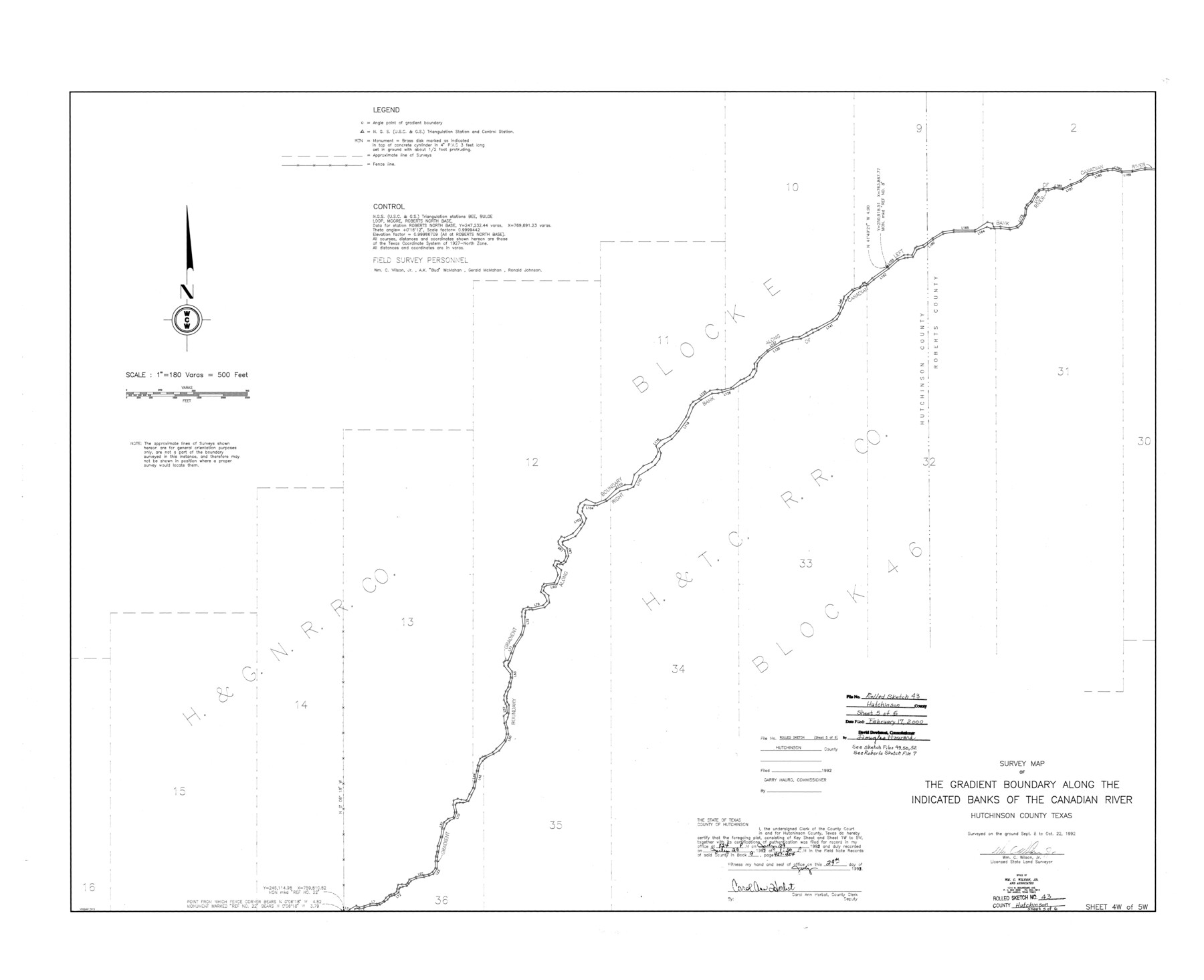
Hutchinson County Rolled Sketch 43
Survey map of the Gradient Boundary along the indicated banks of the Canadian River, Hutchinson County, Texas [Sheet 4 of 5]
-
Map/Doc
6315
-
Collection
General Map Collection
-
Object Dates
1992/10/22 (Creation Date)
2000/2/17 (File Date)
-
People and Organizations
Wm. C. Wilson, Jr. (Surveyor/Engineer)
-
Counties
Hutchinson
-
Subjects
Surveying Rolled Sketch
-
Height x Width
40.6 x 49.9 inches
103.1 x 126.7 cm
-
Medium
mylar, print
-
Scale
1" = 180 varas
-
Comments
See Hutchinson County Sketch File 49 (27419), Hutchinson County Sketch File 50 (27434), Hutchinson County Sketch File 52 (27449), Roberts County Sketch File 7 (35316).
Related maps
Hutchinson County Sketch File 49

Print $30.00
- Digital $50.00
Hutchinson County Sketch File 49
1992
Size 14.2 x 8.6 inches
Map/Doc 27419
Hutchinson County Sketch File 50

Print $12.00
- Digital $50.00
Hutchinson County Sketch File 50
1992
Size 14.2 x 8.8 inches
Map/Doc 27434
Hutchinson County Sketch File 52

Print $14.00
- Digital $50.00
Hutchinson County Sketch File 52
1992
Size 14.2 x 8.8 inches
Map/Doc 27449
Roberts County Sketch File 7

Print $16.00
- Digital $50.00
Roberts County Sketch File 7
1992
Size 14.3 x 8.8 inches
Map/Doc 35316
Part of: General Map Collection
McCulloch County

Print $20.00
- Digital $50.00
McCulloch County
1874
Size 21.9 x 16.8 inches
Map/Doc 3856
[Gulf Coast of Texas]
![72705, [Gulf Coast of Texas], General Map Collection](https://historictexasmaps.com/wmedia_w700/maps/72705.tif.jpg)
Print $20.00
- Digital $50.00
[Gulf Coast of Texas]
1881
Size 28.7 x 18.2 inches
Map/Doc 72705
Zapata County Rolled Sketch 12B

Print $40.00
- Digital $50.00
Zapata County Rolled Sketch 12B
1917
Size 55.7 x 40.0 inches
Map/Doc 10166
Cooke County Boundary File 2

Print $19.00
- Digital $50.00
Cooke County Boundary File 2
Size 12.1 x 7.6 inches
Map/Doc 51840
Jeff Davis County Rolled Sketch 30

Print $20.00
- Digital $50.00
Jeff Davis County Rolled Sketch 30
Size 35.7 x 29.7 inches
Map/Doc 6378
Sterling County Rolled Sketch 19

Print $40.00
- Digital $50.00
Sterling County Rolled Sketch 19
1953
Size 53.7 x 47.7 inches
Map/Doc 9951
Cherokee County Working Sketch 1

Print $20.00
- Digital $50.00
Cherokee County Working Sketch 1
1925
Size 22.9 x 24.1 inches
Map/Doc 67956
Liberty County Working Sketch 1

Print $20.00
- Digital $50.00
Liberty County Working Sketch 1
Size 26.5 x 29.7 inches
Map/Doc 70460
Haskell County Sketch File 1A

Print $40.00
- Digital $50.00
Haskell County Sketch File 1A
Size 12.3 x 14.5 inches
Map/Doc 26119
Real County Sketch File 5

Print $20.00
- Digital $50.00
Real County Sketch File 5
Size 16.9 x 20.9 inches
Map/Doc 12228
Bee County Sketch File 1a

Print $12.00
- Digital $50.00
Bee County Sketch File 1a
1846
Size 9.8 x 6.5 inches
Map/Doc 14359
Childress County Rolled Sketch 5

Print $20.00
- Digital $50.00
Childress County Rolled Sketch 5
1913
Size 31.2 x 24.7 inches
Map/Doc 5439
You may also like
Milam County Aerial Photograph Index Sheet 3

Print $20.00
- Digital $50.00
Milam County Aerial Photograph Index Sheet 3
1951
Size 24.3 x 20.4 inches
Map/Doc 86602
Galveston County Sketch File 11b

Print $4.00
- Digital $50.00
Galveston County Sketch File 11b
1876
Size 8.9 x 8.9 inches
Map/Doc 23378
Floyd County Rolled Sketch 10

Print $20.00
- Digital $50.00
Floyd County Rolled Sketch 10
1953
Size 37.8 x 25.0 inches
Map/Doc 5883
Sketch File C, Lamb County

Print $20.00
- Digital $50.00
Sketch File C, Lamb County
1904
Size 21.6 x 26.0 inches
Map/Doc 91069
Real County Working Sketch 55

Print $20.00
- Digital $50.00
Real County Working Sketch 55
1960
Size 21.6 x 35.1 inches
Map/Doc 71947
Val Verde County Working Sketch 40

Print $20.00
- Digital $50.00
Val Verde County Working Sketch 40
1943
Size 31.5 x 29.8 inches
Map/Doc 72175
[Part of Block GG and river sections 69-79]
![90470, [Part of Block GG and river sections 69-79], Twichell Survey Records](https://historictexasmaps.com/wmedia_w700/maps/90470-1.tif.jpg)
Print $20.00
- Digital $50.00
[Part of Block GG and river sections 69-79]
Size 43.2 x 31.2 inches
Map/Doc 90470
Brazoria County Rolled Sketch 36

Print $20.00
- Digital $50.00
Brazoria County Rolled Sketch 36
Size 18.5 x 25.0 inches
Map/Doc 5172
Intracoastal Waterway in Texas - Corpus Christi to Point Isabel including Arroyo Colorado to Mo. Pac. R.R. Bridge Near Harlingen

Print $20.00
- Digital $50.00
Intracoastal Waterway in Texas - Corpus Christi to Point Isabel including Arroyo Colorado to Mo. Pac. R.R. Bridge Near Harlingen
1933
Size 27.9 x 40.8 inches
Map/Doc 61862
Shelby County Rolled Sketch 2

Print $20.00
- Digital $50.00
Shelby County Rolled Sketch 2
Size 20.3 x 30.7 inches
Map/Doc 7775
Roberts County Working Sketch 8

Print $20.00
- Digital $50.00
Roberts County Working Sketch 8
1963
Size 21.9 x 26.0 inches
Map/Doc 63534
Midland County Rolled Sketch 4B

Print $40.00
- Digital $50.00
Midland County Rolled Sketch 4B
1951
Size 77.5 x 25.1 inches
Map/Doc 10725