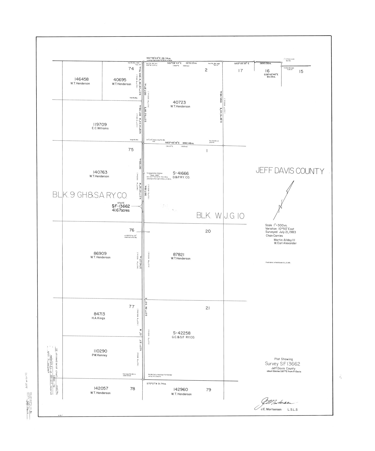
Jeff Davis County Rolled Sketch 30
Plat showing survey SF-13662, Jeff Davis County
-
Map/Doc
6378
-
Collection
General Map Collection
-
Object Dates
1983/7/21 (Survey Date)
1983/12/19 (File Date)
-
People and Organizations
James E. Mortensen (Surveyor/Engineer)
Martin Allday III (Chainman/Field Personnel)
W. Earl Alexander (Chainman/Field Personnel)
-
Counties
Jeff Davis
-
Subjects
Surveying Rolled Sketch
-
Height x Width
35.7 x 29.7 inches
90.7 x 75.4 cm
-
Scale
1" = 300 varas
Part of: General Map Collection
Wood County Boundary File 4

Print $6.00
- Digital $50.00
Wood County Boundary File 4
Size 12.1 x 8.1 inches
Map/Doc 60167
Pecos County Rolled Sketch 148

Print $20.00
- Digital $50.00
Pecos County Rolled Sketch 148
Size 30.3 x 42.6 inches
Map/Doc 7279
Mills County Working Sketch 17

Print $20.00
- Digital $50.00
Mills County Working Sketch 17
1963
Size 20.4 x 17.9 inches
Map/Doc 71047
Presidio County Working Sketch 86

Print $20.00
- Digital $50.00
Presidio County Working Sketch 86
1971
Size 45.4 x 42.2 inches
Map/Doc 71763
Aransas County Boundary File 4

Print $30.00
- Digital $50.00
Aransas County Boundary File 4
Size 9.2 x 7.8 inches
Map/Doc 49790

Coke County Rolled Sketch 16

Print $20.00
- Digital $50.00
Coke County Rolled Sketch 16
1950
Size 44.0 x 34.3 inches
Map/Doc 8630

Flight Mission No. CGI-3N, Frame 94, Cameron County

Print $20.00
- Digital $50.00
Flight Mission No. CGI-3N, Frame 94, Cameron County
1954
Size 18.6 x 22.1 inches
Map/Doc 84574
Presidio County Sketch File 57

Print $8.00
- Digital $50.00
Presidio County Sketch File 57
1938
Size 14.3 x 8.9 inches
Map/Doc 34624
Jeff Davis County Boundary File 1a

Print $8.00
- Digital $50.00
Jeff Davis County Boundary File 1a
Size 14.3 x 8.8 inches
Map/Doc 55501
Webb County Working Sketch 27

Print $20.00
- Digital $50.00
Webb County Working Sketch 27
1932
Size 24.0 x 19.5 inches
Map/Doc 72392
You may also like
McMullen County Working Sketch 59

Print $20.00
- Digital $50.00
McMullen County Working Sketch 59
1984
Size 24.0 x 27.7 inches
Map/Doc 70760
Midland County Boundary File 4a

Print $40.00
- Digital $50.00
Midland County Boundary File 4a
Size 36.2 x 54.5 inches
Map/Doc 57185
Ellis County Working Sketch 4

Print $40.00
- Digital $50.00
Ellis County Working Sketch 4
1997
Size 48.0 x 30.3 inches
Map/Doc 69020
General Highway Map, Midland County, Texas

Print $20.00
General Highway Map, Midland County, Texas
1940
Size 18.2 x 24.5 inches
Map/Doc 79197
Presidio County Rolled Sketch WR1

Print $20.00
- Digital $50.00
Presidio County Rolled Sketch WR1
1927
Size 20.4 x 23.0 inches
Map/Doc 7421
El Paso County Rolled Sketch 40

Print $20.00
- Digital $50.00
El Paso County Rolled Sketch 40
1929
Size 43.6 x 25.2 inches
Map/Doc 5827
Wise County Working Sketch 24

Print $40.00
- Digital $50.00
Wise County Working Sketch 24
1983
Size 37.1 x 58.2 inches
Map/Doc 72638
Harris County Working Sketch 99

Print $20.00
- Digital $50.00
Harris County Working Sketch 99
1979
Size 46.6 x 30.1 inches
Map/Doc 65991
Map of Hardin County

Print $20.00
- Digital $50.00
Map of Hardin County
1902
Size 40.8 x 43.9 inches
Map/Doc 4971
Nueces County Sketch File 61

Print $4.00
- Digital $50.00
Nueces County Sketch File 61
1930
Size 10.5 x 8.6 inches
Map/Doc 32969
El Paso County Working Sketch 25

Print $20.00
- Digital $50.00
El Paso County Working Sketch 25
1962
Size 42.7 x 41.9 inches
Map/Doc 69047
Current Miscellaneous File 117

Print $8.00
- Digital $50.00
Current Miscellaneous File 117
2001
Size 11.2 x 8.8 inches
Map/Doc 74823