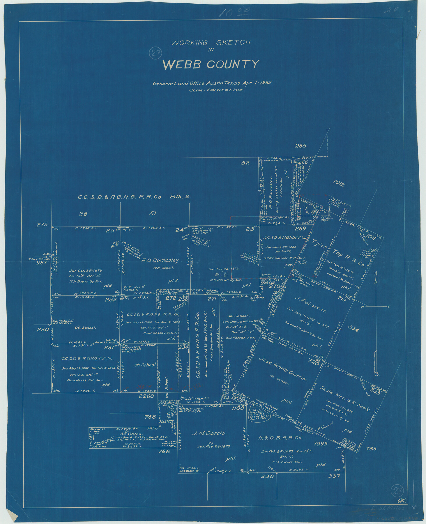
Webb County Working Sketch 27
-
Map/Doc
72392
-
Collection
General Map Collection
-
Object Dates
4/1/1932 (Creation Date)
-
Counties
Webb
-
Subjects
Surveying Working Sketch
-
Height x Width
24.0 x 19.5 inches
61.0 x 49.5 cm
-
Scale
1" = 600 varas
Part of: General Map Collection

Bastrop County Working Sketch Graphic Index

Print $40.00
- Digital $50.00
Bastrop County Working Sketch Graphic Index
1955
Size 49.6 x 40.9 inches
Map/Doc 76462
Flight Mission No. DQO-2K, Frame 85, Galveston County

Print $20.00
- Digital $50.00
Flight Mission No. DQO-2K, Frame 85, Galveston County
1952
Size 18.9 x 22.5 inches
Map/Doc 85012
Map of Fannin County

Print $20.00
- Digital $50.00
Map of Fannin County
1866
Size 21.9 x 18.1 inches
Map/Doc 3534
Palo Pinto County Rolled Sketch 6

Print $40.00
- Digital $50.00
Palo Pinto County Rolled Sketch 6
1917
Size 64.4 x 35.4 inches
Map/Doc 9673
Fractional Township No. 7 South Range No. 6 East of the Indian Meridian, Indian Territory

Print $20.00
- Digital $50.00
Fractional Township No. 7 South Range No. 6 East of the Indian Meridian, Indian Territory
1898
Size 19.2 x 24.3 inches
Map/Doc 75211
Brooks County Working Sketch 11

Print $20.00
- Digital $50.00
Brooks County Working Sketch 11
1942
Size 41.8 x 23.5 inches
Map/Doc 67795
Duval County Sketch File 21

Print $42.00
- Digital $50.00
Duval County Sketch File 21
1879
Size 17.0 x 28.8 inches
Map/Doc 11385
Archer County Sketch File 10

Print $5.00
- Digital $50.00
Archer County Sketch File 10
Size 10.2 x 15.9 inches
Map/Doc 13642
Red River County Working Sketch 16

Print $20.00
- Digital $50.00
Red River County Working Sketch 16
1953
Size 21.8 x 23.4 inches
Map/Doc 71999
Wichita County Working Sketch 3

Print $20.00
- Digital $50.00
Wichita County Working Sketch 3
1913
Size 22.2 x 15.6 inches
Map/Doc 72512
Right of Way & Track Map Houston & Brazos Valley Ry. operated by Houston & Brazos Valley Ry. Co., Hoskins Mound Branch

Print $40.00
- Digital $50.00
Right of Way & Track Map Houston & Brazos Valley Ry. operated by Houston & Brazos Valley Ry. Co., Hoskins Mound Branch
1924
Size 25.3 x 56.4 inches
Map/Doc 64611
You may also like
Map of the County of Calhoun

Print $20.00
- Digital $50.00
Map of the County of Calhoun
1852
Size 21.0 x 20.4 inches
Map/Doc 4431
Rio Grande, McAllen Sheet

Print $20.00
- Digital $50.00
Rio Grande, McAllen Sheet
1937
Size 37.4 x 37.5 inches
Map/Doc 65118
[Capitol Leagues 217-228, 238, and vicinity]
![90695, [Capitol Leagues 217-228, 238, and vicinity], Twichell Survey Records](https://historictexasmaps.com/wmedia_w700/maps/90695-1.tif.jpg)
Print $20.00
- Digital $50.00
[Capitol Leagues 217-228, 238, and vicinity]
Size 23.8 x 12.9 inches
Map/Doc 90695
Hood County Sketch File 1

Print $5.00
- Digital $50.00
Hood County Sketch File 1
Size 11.0 x 15.2 inches
Map/Doc 26569
Robertson & Scott V Ranch situated in Crosby County, Texas

Print $40.00
- Digital $50.00
Robertson & Scott V Ranch situated in Crosby County, Texas
Size 42.0 x 50.3 inches
Map/Doc 89753
Comal County Sketch File 3b

Print $20.00
- Digital $50.00
Comal County Sketch File 3b
1847
Size 12.4 x 16.1 inches
Map/Doc 19003
Atascosa County Sketch File A

Print $40.00
- Digital $50.00
Atascosa County Sketch File A
Size 16.3 x 15.6 inches
Map/Doc 10869
Nueces County Sketch File 25a

Print $6.00
- Digital $50.00
Nueces County Sketch File 25a
1890
Size 14.2 x 8.4 inches
Map/Doc 32578
Limestone County Working Sketch 13

Print $20.00
- Digital $50.00
Limestone County Working Sketch 13
1922
Size 11.8 x 11.8 inches
Map/Doc 70563
Seymour, Baylor County, Texas

Print $20.00
Seymour, Baylor County, Texas
1890
Size 15.4 x 24.2 inches
Map/Doc 89207
Brooks County Rolled Sketch 28

Print $20.00
- Digital $50.00
Brooks County Rolled Sketch 28
1947
Size 28.9 x 32.0 inches
Map/Doc 5346
Angelina County Working Sketch 17

Print $20.00
- Digital $50.00
Angelina County Working Sketch 17
1942
Size 18.6 x 13.8 inches
Map/Doc 67098