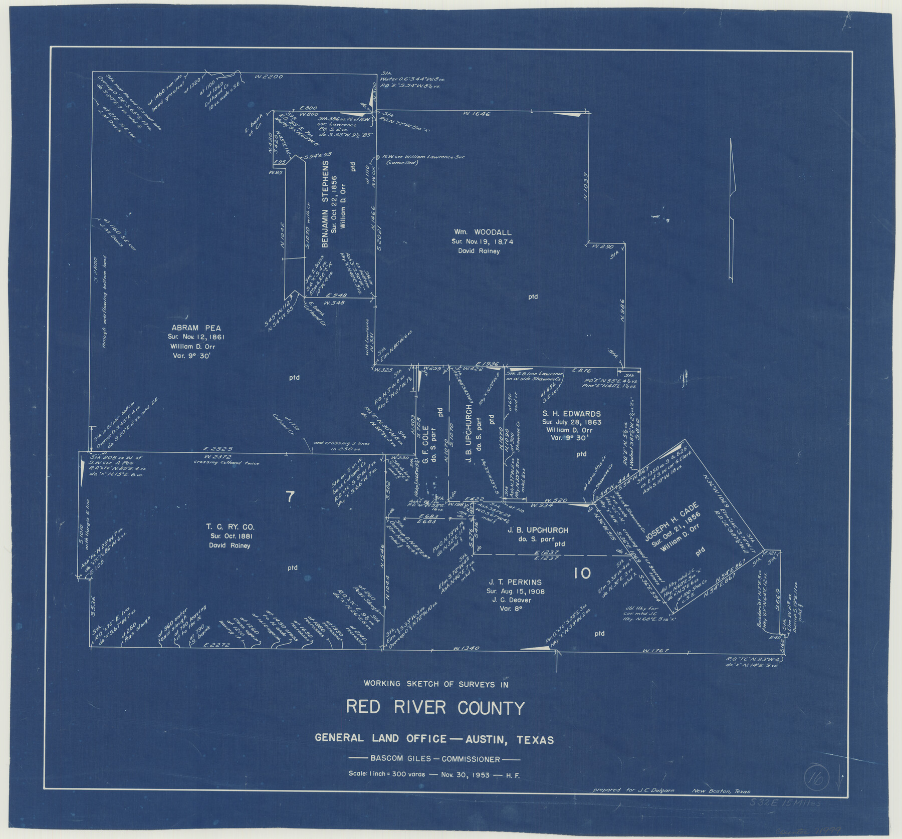
Red River County Working Sketch 16
-
Map/Doc
71999
-
Collection
General Map Collection
-
Object Dates
11/30/1953 (Creation Date)
-
People and Organizations
Herman Forbes (Draftsman)
-
Counties
Red River
-
Subjects
Surveying Working Sketch
-
Height x Width
21.8 x 23.4 inches
55.4 x 59.4 cm
-
Scale
1" = 300 varas
Part of: General Map Collection
Pecos County Working Sketch 110

Print $40.00
- Digital $50.00
Pecos County Working Sketch 110
1972
Size 32.3 x 50.6 inches
Map/Doc 71583
Fisher County Sketch File 19a

Print $42.00
- Digital $50.00
Fisher County Sketch File 19a
1898
Size 14.1 x 8.9 inches
Map/Doc 22595
Real County Working Sketch 46

Print $20.00
- Digital $50.00
Real County Working Sketch 46
1956
Size 21.2 x 18.9 inches
Map/Doc 71938
Val Verde County Working Sketch 35

Print $20.00
- Digital $50.00
Val Verde County Working Sketch 35
1941
Size 31.1 x 20.7 inches
Map/Doc 72170
Live Oak County Sketch File 32

Print $6.00
- Digital $50.00
Live Oak County Sketch File 32
1951
Size 11.1 x 8.6 inches
Map/Doc 30330
Erath County Working Sketch 39

Print $20.00
- Digital $50.00
Erath County Working Sketch 39
1976
Size 26.9 x 28.0 inches
Map/Doc 69120
Nueces County NRC Article 33.136 Sketch 8

Print $26.00
- Digital $50.00
Nueces County NRC Article 33.136 Sketch 8
2004
Size 21.9 x 33.1 inches
Map/Doc 82916
Parker County Rolled Sketch 7

Print $20.00
- Digital $50.00
Parker County Rolled Sketch 7
Size 24.5 x 19.1 inches
Map/Doc 89050
Runnels County Working Sketch 19

Print $20.00
- Digital $50.00
Runnels County Working Sketch 19
1950
Size 24.9 x 30.8 inches
Map/Doc 63615
Panola County Working Sketch 13

Print $40.00
- Digital $50.00
Panola County Working Sketch 13
1945
Map/Doc 71422
Refugio County Working Sketch 7

Print $20.00
- Digital $50.00
Refugio County Working Sketch 7
1939
Size 21.3 x 23.2 inches
Map/Doc 63516
United States

Print $20.00
- Digital $50.00
United States
1851
Size 10.8 x 15.1 inches
Map/Doc 93799
You may also like
Crockett County Rolled Sketch 96

Print $20.00
- Digital $50.00
Crockett County Rolled Sketch 96
1986
Size 25.2 x 28.9 inches
Map/Doc 5635
A Plat of the League of land surveyed on the south-west side of the Rio San Bernardo between it and the Bay-Prairie

Print $20.00
- Digital $50.00
A Plat of the League of land surveyed on the south-west side of the Rio San Bernardo between it and the Bay-Prairie
1831
Size 37.3 x 24.0 inches
Map/Doc 13
Flight Mission No. DQO-1K, Frame 94, Galveston County

Print $20.00
- Digital $50.00
Flight Mission No. DQO-1K, Frame 94, Galveston County
1952
Size 18.9 x 22.6 inches
Map/Doc 84990
San Jacinto County Working Sketch 17

Print $40.00
- Digital $50.00
San Jacinto County Working Sketch 17
1934
Size 36.6 x 48.2 inches
Map/Doc 63730
Motley County Sketch File 6 (N)

Print $20.00
- Digital $50.00
Motley County Sketch File 6 (N)
1900
Size 14.0 x 8.6 inches
Map/Doc 32004
Webb County Working Sketch 12

Print $20.00
- Digital $50.00
Webb County Working Sketch 12
1921
Size 15.9 x 14.6 inches
Map/Doc 72377
Hansford County

Print $20.00
- Digital $50.00
Hansford County
1932
Size 39.6 x 38.5 inches
Map/Doc 77301
Brewster County Rolled Sketch 81

Print $20.00
- Digital $50.00
Brewster County Rolled Sketch 81
Size 38.9 x 32.6 inches
Map/Doc 41812
Ward County Working Sketch 47

Print $20.00
- Digital $50.00
Ward County Working Sketch 47
1974
Size 41.3 x 33.9 inches
Map/Doc 72353
Presidio County Working Sketch 140

Print $20.00
- Digital $50.00
Presidio County Working Sketch 140
1990
Size 29.8 x 39.9 inches
Map/Doc 71818
Wilbarger County Working Sketch 19

Print $20.00
- Digital $50.00
Wilbarger County Working Sketch 19
1972
Size 36.6 x 38.3 inches
Map/Doc 72557
A Map of That Part of Dallas County, lying in Nacogdoches Land District

Print $20.00
- Digital $50.00
A Map of That Part of Dallas County, lying in Nacogdoches Land District
1854
Size 29.9 x 22.6 inches
Map/Doc 4525