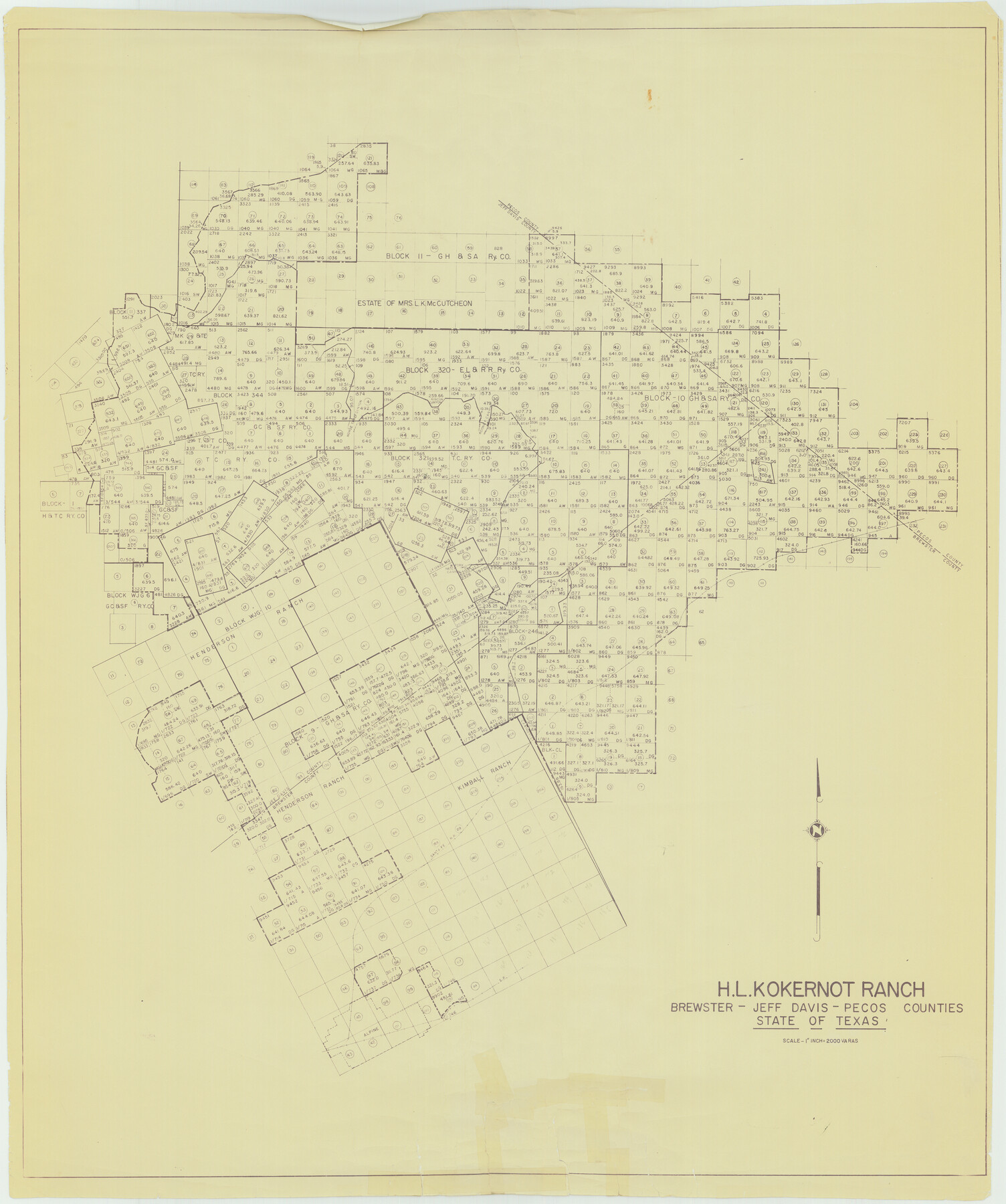
Brewster County Rolled Sketch 81
H.L. Kokernot Ranch, Brewster - Jeff Davis - Pecos Counties, State of Texas
-
Map/Doc
41812
-
Collection
General Map Collection
-
Counties
Brewster Jeff Davis Pecos
-
Subjects
Surveying Rolled Sketch
-
Height x Width
38.9 x 32.6 inches
98.8 x 82.8 cm
-
Medium
van dyke/brownline/sepia
-
Scale
1" = 2000 varas
-
Comments
See Brewster County Rolled Sketch 81 (8494) for additional sketch.
Related maps
Brewster County Rolled Sketch 81

Print $20.00
- Digital $50.00
Brewster County Rolled Sketch 81
1945
Size 30.8 x 33.9 inches
Map/Doc 8494
Part of: General Map Collection
Freestone County Working Sketch Graphic Index

Print $20.00
- Digital $50.00
Freestone County Working Sketch Graphic Index
1988
Size 43.0 x 42.1 inches
Map/Doc 76547
McMullen County Rolled Sketch 9

Print $20.00
- Digital $50.00
McMullen County Rolled Sketch 9
Size 34.4 x 40.9 inches
Map/Doc 6726
Atascosa County Sketch File 40

Print $40.00
- Digital $50.00
Atascosa County Sketch File 40
1881
Size 15.2 x 12.6 inches
Map/Doc 13835
Presidio County Rolled Sketch 134

Print $20.00
- Digital $50.00
Presidio County Rolled Sketch 134
Size 26.6 x 39.6 inches
Map/Doc 7401
Matagorda County Aerial Photograph Index Sheet 8

Print $20.00
- Digital $50.00
Matagorda County Aerial Photograph Index Sheet 8
1953
Size 19.6 x 23.8 inches
Map/Doc 83729
Robertson County Sketch File 12

Print $18.00
Robertson County Sketch File 12
1987
Size 11.4 x 8.8 inches
Map/Doc 35404
[Sketch for Mineral Application 24072, San Jacinto River]
![65593, [Sketch for Mineral Application 24072, San Jacinto River], General Map Collection](https://historictexasmaps.com/wmedia_w700/maps/65593.tif.jpg)
Print $20.00
- Digital $50.00
[Sketch for Mineral Application 24072, San Jacinto River]
1929
Size 19.1 x 16.9 inches
Map/Doc 65593
Flight Mission No. BQY-4M, Frame 56, Harris County

Print $20.00
- Digital $50.00
Flight Mission No. BQY-4M, Frame 56, Harris County
1953
Size 18.6 x 22.4 inches
Map/Doc 85265
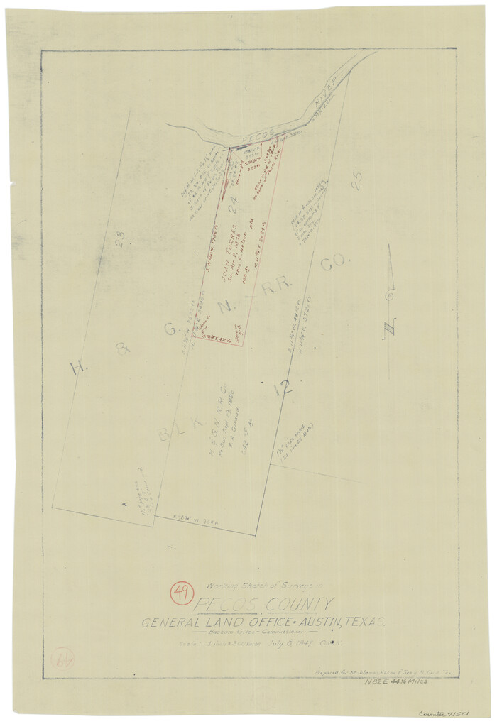
Pecos County Working Sketch 49
Print $20.00
- Digital $50.00
Pecos County Working Sketch 49
1947
Size 22.4 x 15.3 inches
Map/Doc 71521
Controlled Mosaic by Jack Amman Photogrammetric Engineers, Inc - Sheet 27

Print $20.00
- Digital $50.00
Controlled Mosaic by Jack Amman Photogrammetric Engineers, Inc - Sheet 27
1954
Size 20.0 x 24.0 inches
Map/Doc 83478
Map of the City of Kerens (Navarro County) Texas

Print $40.00
- Digital $50.00
Map of the City of Kerens (Navarro County) Texas
1958
Size 44.2 x 54.9 inches
Map/Doc 93670
Tom Green County Sketch File 31

Print $40.00
- Digital $50.00
Tom Green County Sketch File 31
Size 14.2 x 13.4 inches
Map/Doc 38190
You may also like
Colorado County Sketch File 4

Print $40.00
- Digital $50.00
Colorado County Sketch File 4
1858
Size 12.8 x 15.7 inches
Map/Doc 18917
Current Miscellaneous File 84

Print $10.00
- Digital $50.00
Current Miscellaneous File 84
1954
Size 11.2 x 8.8 inches
Map/Doc 74231
Brazoria County NRC Article 33.136 Sketch 10

Print $23.00
- Digital $50.00
Brazoria County NRC Article 33.136 Sketch 10
2007
Size 25.7 x 35.7 inches
Map/Doc 87933
Blocks 3 and 4 Capitol Syndicate Subdivision of Capitol Leagues

Print $20.00
- Digital $50.00
Blocks 3 and 4 Capitol Syndicate Subdivision of Capitol Leagues
1906
Size 17.5 x 27.4 inches
Map/Doc 90581
Webb County Rolled Sketch 53

Print $40.00
- Digital $50.00
Webb County Rolled Sketch 53
1944
Size 83.5 x 28.6 inches
Map/Doc 49483
El Paso County State Real Property Sketch 2

Print $20.00
- Digital $50.00
El Paso County State Real Property Sketch 2
2007
Size 24.4 x 36.2 inches
Map/Doc 88671
Flight Mission No. CRC-2R, Frame 137, Chambers County

Print $20.00
- Digital $50.00
Flight Mission No. CRC-2R, Frame 137, Chambers County
1956
Size 18.6 x 22.3 inches
Map/Doc 84753
Hays County Working Sketch 7

Print $20.00
- Digital $50.00
Hays County Working Sketch 7
1941
Size 16.3 x 16.2 inches
Map/Doc 66081
Connected Map of Austin's Colony

Print $20.00
- Digital $50.00
Connected Map of Austin's Colony
1892
Size 47.5 x 43.0 inches
Map/Doc 76074
Ellis County Working Sketch 1

Print $20.00
- Digital $50.00
Ellis County Working Sketch 1
1939
Size 19.1 x 19.3 inches
Map/Doc 69017
Pecos County Sketch File 29b

Print $12.00
- Digital $50.00
Pecos County Sketch File 29b
1929
Size 14.3 x 8.8 inches
Map/Doc 33692
Cochran County Rolled Sketch A

Print $40.00
- Digital $50.00
Cochran County Rolled Sketch A
Size 28.5 x 55.3 inches
Map/Doc 8604