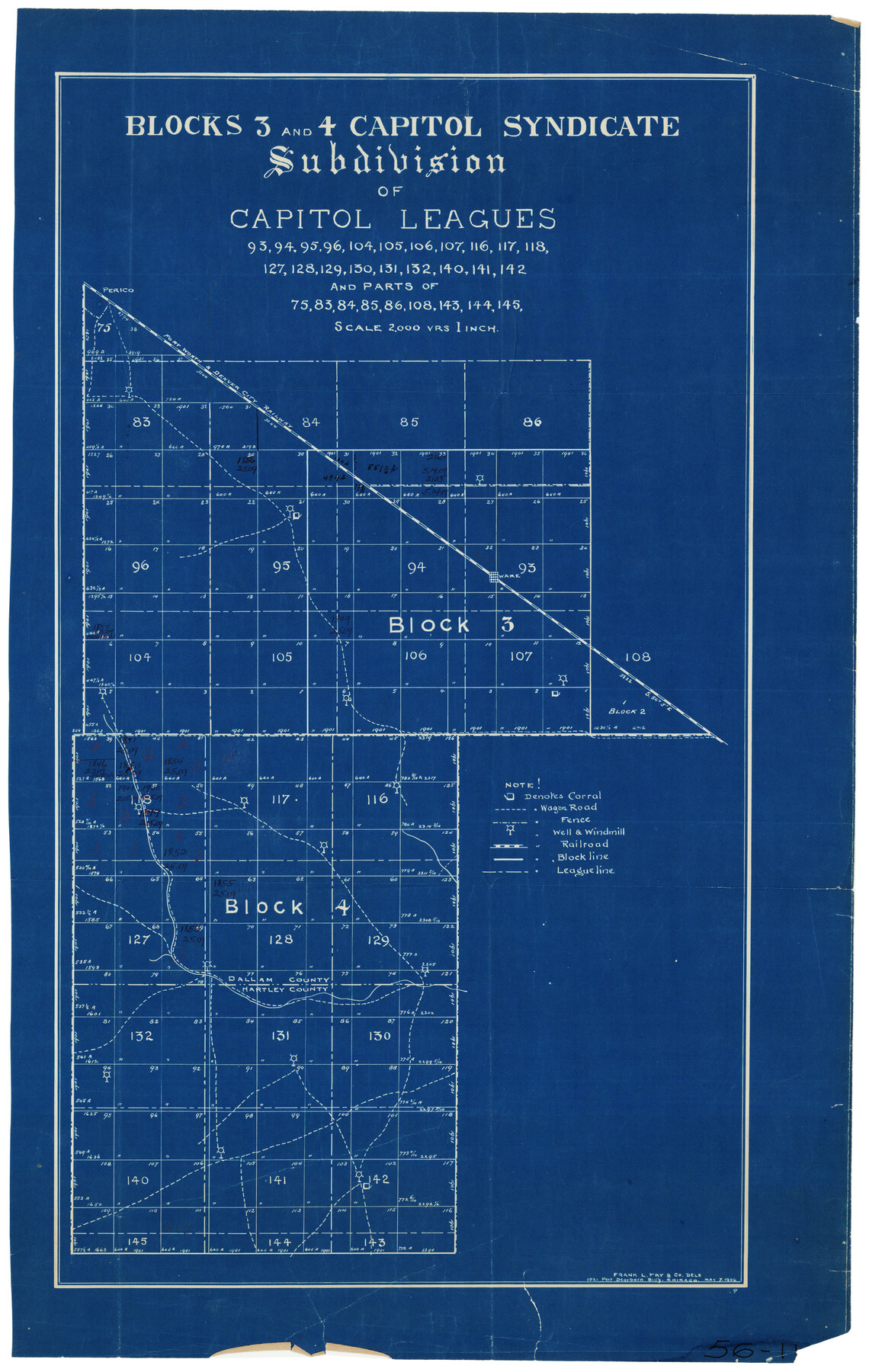
Blocks 3 and 4 Capitol Syndicate Subdivision of Capitol Leagues
56-11
-
Map/Doc
90581
-
Collection
Twichell Survey Records
-
Object Dates
5/7/1906 (Creation Date)
-
Counties
Dallam
-
Height x Width
17.5 x 27.4 inches
44.5 x 69.6 cm
-
Comments
Covers Leagues: 93, 94, 95, 96, 104, 105, 106, 107, 116, 117, 118, 127, 128, 129, 130, 131, 132, 140, 141, 142 and parts of 75, 83, 84, 85, 86, 108, 143, 144, 145
Part of: Twichell Survey Records
Property Line Map, Low Rent Housing Project Texas 18-1, Housing Authority of the City of Lubbock

Print $20.00
- Digital $50.00
Property Line Map, Low Rent Housing Project Texas 18-1, Housing Authority of the City of Lubbock
1941
Size 42.2 x 27.9 inches
Map/Doc 92753
[Yates survey 34 1/2 and vicinity]
![91689, [Yates survey 34 1/2 and vicinity], Twichell Survey Records](https://historictexasmaps.com/wmedia_w700/maps/91689-1.tif.jpg)
Print $20.00
- Digital $50.00
[Yates survey 34 1/2 and vicinity]
Size 12.6 x 17.8 inches
Map/Doc 91689
[Blk. B, part of Blk. M, and north line of Morris County School Land]
![90359, [Blk. B, part of Blk. M, and north line of Morris County School Land], Twichell Survey Records](https://historictexasmaps.com/wmedia_w700/maps/90359-1.tif.jpg)
Print $20.00
- Digital $50.00
[Blk. B, part of Blk. M, and north line of Morris County School Land]
Size 23.9 x 22.7 inches
Map/Doc 90359
South Part Section 55, Block A

Print $20.00
- Digital $50.00
South Part Section 55, Block A
1949
Size 20.3 x 13.0 inches
Map/Doc 92755
[SE Pt. of Stephens County]
![89639, [SE Pt. of Stephens County], Twichell Survey Records](https://historictexasmaps.com/wmedia_w700/maps/89639-1.tif.jpg)
Print $20.00
- Digital $50.00
[SE Pt. of Stephens County]
Size 38.1 x 35.9 inches
Map/Doc 89639
[North Central Part of County]
![90555, [North Central Part of County], Twichell Survey Records](https://historictexasmaps.com/wmedia_w700/maps/90555-1.tif.jpg)
Print $2.00
- Digital $50.00
[North Central Part of County]
Size 6.7 x 9.9 inches
Map/Doc 90555
Laneer vs. Bivins, Potter County, Texas

Print $20.00
- Digital $50.00
Laneer vs. Bivins, Potter County, Texas
Size 21.1 x 18.8 inches
Map/Doc 93062
[Sketch Showing Wm. T. Brewer, John R. Taylor, Wm. F. Butler, Timothy DeVore, L. M. Thorn and adjoining surveys]
![90231, [Sketch Showing Wm. T. Brewer, John R. Taylor, Wm. F. Butler, Timothy DeVore, L. M. Thorn and adjoining surveys], Twichell Survey Records](https://historictexasmaps.com/wmedia_w700/maps/90231-1.tif.jpg)
Print $20.00
- Digital $50.00
[Sketch Showing Wm. T. Brewer, John R. Taylor, Wm. F. Butler, Timothy DeVore, L. M. Thorn and adjoining surveys]
Size 27.2 x 19.4 inches
Map/Doc 90231
Brazos River Conservation and Reclamation District Official Boundary Line Survey, Parmer County

Print $20.00
- Digital $50.00
Brazos River Conservation and Reclamation District Official Boundary Line Survey, Parmer County
Size 24.5 x 16.9 inches
Map/Doc 91658
Block 32, Township 4 North

Print $20.00
- Digital $50.00
Block 32, Township 4 North
Size 17.5 x 25.3 inches
Map/Doc 92507
Working Sketch in Randall and Swisher Cos.

Print $2.00
- Digital $50.00
Working Sketch in Randall and Swisher Cos.
Size 5.8 x 4.1 inches
Map/Doc 93047
[Sketch showing Panhandle and Santa Fe Railroad, Compress Spur and Seed House structures]
![92880, [Sketch showing Panhandle and Santa Fe Railroad, Compress Spur and Seed House structures], Twichell Survey Records](https://historictexasmaps.com/wmedia_w700/maps/92880-1.tif.jpg)
Print $20.00
- Digital $50.00
[Sketch showing Panhandle and Santa Fe Railroad, Compress Spur and Seed House structures]
Size 20.8 x 22.8 inches
Map/Doc 92880
You may also like
[Map showing T&P Lands in El Paso County]
![88931, [Map showing T&P Lands in El Paso County], Library of Congress](https://historictexasmaps.com/wmedia_w700/maps/88931.tif.jpg)
Print $20.00
[Map showing T&P Lands in El Paso County]
Size 22.4 x 17.3 inches
Map/Doc 88931
Cottle County Working Sketch 9

Print $20.00
- Digital $50.00
Cottle County Working Sketch 9
1919
Size 33.3 x 32.1 inches
Map/Doc 68319
Travis County Appraisal District Plat Map 2_1804

Print $20.00
- Digital $50.00
Travis County Appraisal District Plat Map 2_1804
Size 21.6 x 26.5 inches
Map/Doc 94203
Milam [District]
![1948, Milam [District], General Map Collection](https://historictexasmaps.com/wmedia_w700/maps/1948.tif.jpg)
Print $40.00
- Digital $50.00
Milam [District]
1850
Size 60.8 x 46.4 inches
Map/Doc 1948
Duval County Working Sketch 2

Print $20.00
- Digital $50.00
Duval County Working Sketch 2
1919
Size 16.4 x 15.0 inches
Map/Doc 76443
Smith County Working Sketch 8

Print $20.00
- Digital $50.00
Smith County Working Sketch 8
1941
Size 28.9 x 22.7 inches
Map/Doc 63893
Map of Bastrop District

Print $20.00
- Digital $50.00
Map of Bastrop District
1847
Size 22.9 x 28.3 inches
Map/Doc 3275
The Judicial District/County of Burnet. Boundaries Redefined, December 6, 1841

Print $20.00
The Judicial District/County of Burnet. Boundaries Redefined, December 6, 1841
2020
Size 19.2 x 21.6 inches
Map/Doc 96323
Refugio County Sketch File 6

Print $4.00
- Digital $50.00
Refugio County Sketch File 6
1856
Size 8.0 x 13.7 inches
Map/Doc 35249
Live Oak County Rolled Sketch 8

Print $20.00
- Digital $50.00
Live Oak County Rolled Sketch 8
1969
Size 43.5 x 32.8 inches
Map/Doc 9455
San Antonio of the 17th, 18th, and 19th Centuries: A Chronology of Her Romantic Past

San Antonio of the 17th, 18th, and 19th Centuries: A Chronology of Her Romantic Past
1929
Size 8.1 x 5.1 inches
Map/Doc 97044
Flight Mission No. BRE-1P, Frame 153, Nueces County

Print $20.00
- Digital $50.00
Flight Mission No. BRE-1P, Frame 153, Nueces County
1956
Size 18.5 x 22.5 inches
Map/Doc 86714