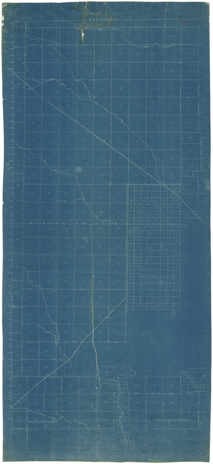
Dallam County Sketch File 12

Print $40.00
- Digital $50.00
Dallam County Sketch File 12
Size: 50.0 x 9.1 inches
10360
Lipscomb County Sketch File 1

Print $40.00
- Digital $50.00
Lipscomb County Sketch File 1
Size: 51.7 x 14.2 inches
10525
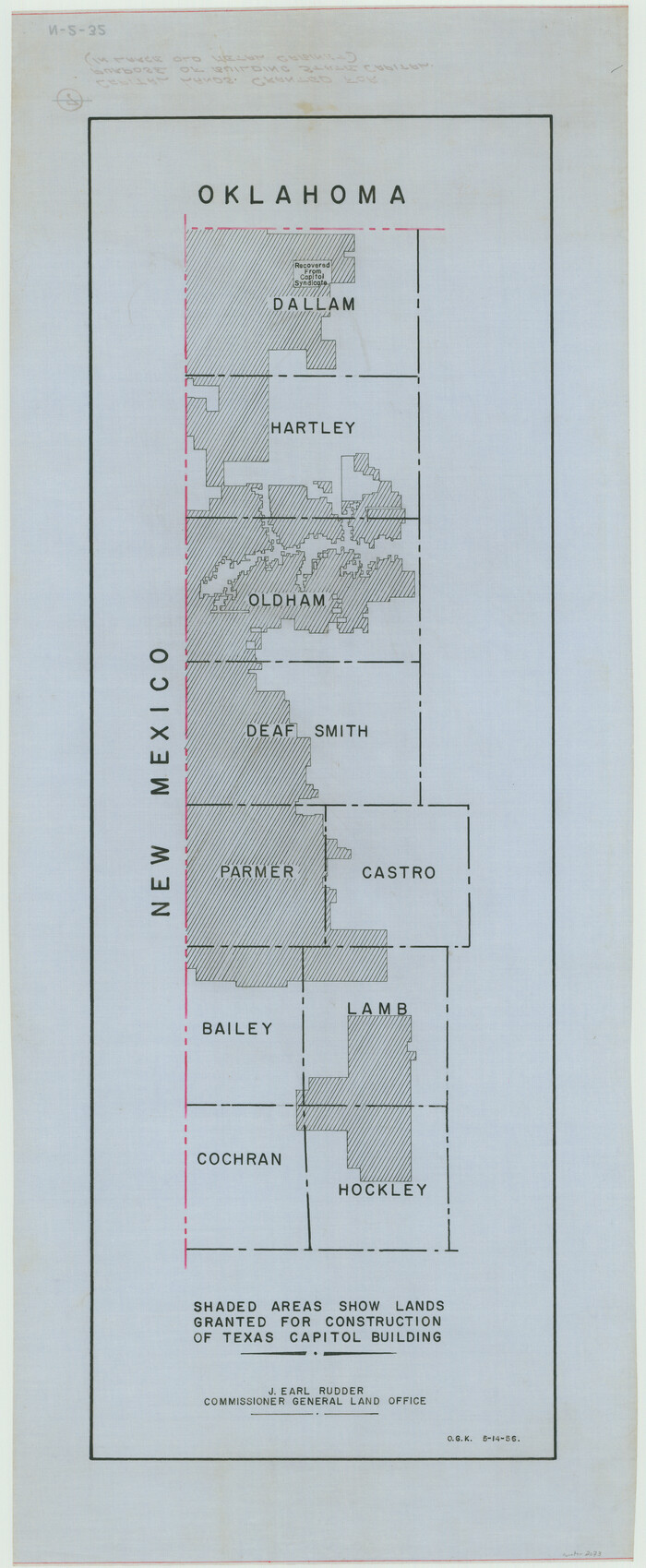
Capitol Land Reservation

Print $40.00
- Digital $50.00
Capitol Land Reservation
1880
Size: 115.6 x 36.6 inches
10785
Dallam County Sketch File 1

Print $22.00
- Digital $50.00
Dallam County Sketch File 1
1885
Size: 29.5 x 27.1 inches
11277
Dallam County Sketch File 2

Print $260.00
- Digital $50.00
Dallam County Sketch File 2
1886
Size: 29.9 x 17.4 inches
11278
Dallam County Sketch File 4

Print $20.00
- Digital $50.00
Dallam County Sketch File 4
Size: 27.7 x 8.5 inches
11279
Dallam County Sketch File 13

Print $20.00
- Digital $50.00
Dallam County Sketch File 13
Size: 22.2 x 20.3 inches
11280
Dallam County Sketch File A

Print $20.00
- Digital $50.00
Dallam County Sketch File A
1903
Size: 32.3 x 20.9 inches
11281
Hartley County Sketch File 6

Print $20.00
- Digital $50.00
Hartley County Sketch File 6
Size: 30.5 x 25.6 inches
11698
Hartley County Sketch File 12

Print $20.00
- Digital $50.00
Hartley County Sketch File 12
1906
Size: 16.3 x 12.4 inches
11736
Sherman County Sketch File 2

Print $20.00
- Digital $50.00
Sherman County Sketch File 2
Size: 19.5 x 36.3 inches
12323
[Young Territory]

Print $40.00
- Digital $50.00
[Young Territory]
1875
Size: 49.0 x 87.4 inches
16784
Map of the Capitol Land Reservation

Print $20.00
- Digital $50.00
Map of the Capitol Land Reservation
1880
Size: 43.5 x 34.6 inches
1751
[Map showing resurvey of Capitol Leagues in Hartley & Dallam Counties, Texas]
Print $40.00
- Digital $50.00
[Map showing resurvey of Capitol Leagues in Hartley & Dallam Counties, Texas]
1918
Size: 66.9 x 31.0 inches
1753
[Map of Surveys in Dallam, Texas]
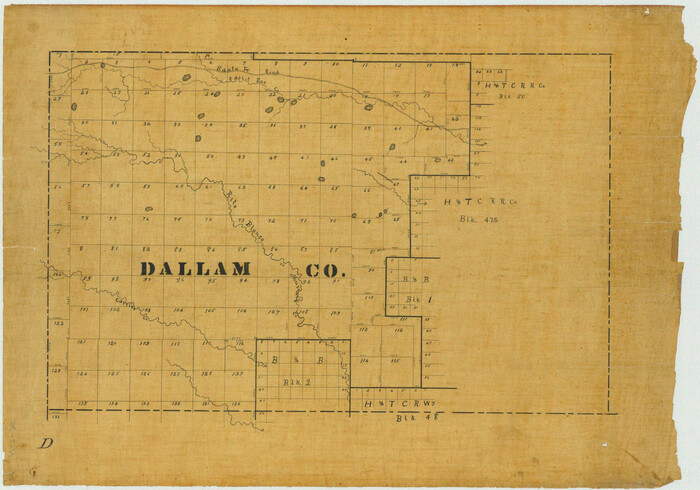
Print $20.00
- Digital $50.00
[Map of Surveys in Dallam, Texas]
1910
Size: 19.5 x 27.8 inches
1768
Dallam County Sketch File 3

Print $4.00
- Digital $50.00
Dallam County Sketch File 3
Size: 14.6 x 9.0 inches
20337
Dallam County Sketch File 5

Print $22.00
- Digital $50.00
Dallam County Sketch File 5
1880
Size: 14.2 x 8.8 inches
20339
Dallam County Sketch File 6

Print $60.00
- Digital $50.00
Dallam County Sketch File 6
Size: 12.4 x 17.0 inches
20350
Dallam County Sketch File 8

Print $8.00
- Digital $50.00
Dallam County Sketch File 8
1903
Size: 11.2 x 8.7 inches
20353
Dallam County Sketch File 9

Print $40.00
- Digital $50.00
Dallam County Sketch File 9
1914
Size: 9.0 x 7.7 inches
20357
Dallam County Sketch File 10

Print $20.00
- Digital $50.00
Dallam County Sketch File 10
1925
Size: 7.2 x 8.6 inches
20367
Dallam County Sketch File 11

Print $4.00
- Digital $50.00
Dallam County Sketch File 11
1935
Size: 11.8 x 7.2 inches
20377
Dallam County Sketch File 14

Print $4.00
- Digital $50.00
Dallam County Sketch File 14
1949
Size: 11.3 x 8.8 inches
20379
Dallam County Sketch File 15

Print $18.00
- Digital $50.00
Dallam County Sketch File 15
1990
Size: 14.4 x 9.0 inches
20381
Dallam County Sketch File 16

Print $28.00
- Digital $50.00
Dallam County Sketch File 16
1993
Size: 11.5 x 8.7 inches
20390
[Capitol lands granted for purpose of building State Capitol]
Print $20.00
- Digital $50.00
[Capitol lands granted for purpose of building State Capitol]
1956
Size: 31.5 x 13.0 inches
2073
[Map Showing Panhandle Counties in Texas]
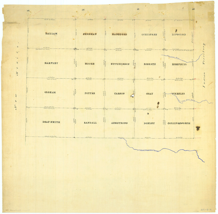
Print $20.00
- Digital $50.00
[Map Showing Panhandle Counties in Texas]
1876
Size: 27.3 x 27.9 inches
2087
Hartley County Sketch File 9

Print $12.00
- Digital $50.00
Hartley County Sketch File 9
1903
Size: 10.8 x 7.2 inches
26094
Hartley County Sketch File 10

Print $57.00
- Digital $50.00
Hartley County Sketch File 10
Size: 9.2 x 7.8 inches
26099
Dallam County Sketch File 12
Print $40.00
- Digital $50.00
Dallam County Sketch File 12
-
Size
50.0 x 9.1 inches
-
Map/Doc
10360
Lipscomb County Sketch File 1
Print $40.00
- Digital $50.00
Lipscomb County Sketch File 1
-
Size
51.7 x 14.2 inches
-
Map/Doc
10525
Capitol Land Reservation
Print $40.00
- Digital $50.00
Capitol Land Reservation
1880
-
Size
115.6 x 36.6 inches
-
Map/Doc
10785
-
Creation Date
1880
Dallam County Sketch File 1
Print $22.00
- Digital $50.00
Dallam County Sketch File 1
1885
-
Size
29.5 x 27.1 inches
-
Map/Doc
11277
-
Creation Date
1885
Dallam County Sketch File 2
Print $260.00
- Digital $50.00
Dallam County Sketch File 2
1886
-
Size
29.9 x 17.4 inches
-
Map/Doc
11278
-
Creation Date
1886
Dallam County Sketch File 4
Print $20.00
- Digital $50.00
Dallam County Sketch File 4
-
Size
27.7 x 8.5 inches
-
Map/Doc
11279
Dallam County Sketch File 13
Print $20.00
- Digital $50.00
Dallam County Sketch File 13
-
Size
22.2 x 20.3 inches
-
Map/Doc
11280
Dallam County Sketch File A
Print $20.00
- Digital $50.00
Dallam County Sketch File A
1903
-
Size
32.3 x 20.9 inches
-
Map/Doc
11281
-
Creation Date
1903
Hartley County Sketch File 6
Print $20.00
- Digital $50.00
Hartley County Sketch File 6
-
Size
30.5 x 25.6 inches
-
Map/Doc
11698
Hartley County Sketch File 12
Print $20.00
- Digital $50.00
Hartley County Sketch File 12
1906
-
Size
16.3 x 12.4 inches
-
Map/Doc
11736
-
Creation Date
1906
Sherman County Sketch File 2
Print $20.00
- Digital $50.00
Sherman County Sketch File 2
-
Size
19.5 x 36.3 inches
-
Map/Doc
12323
[Young Territory]
Print $40.00
- Digital $50.00
[Young Territory]
1875
-
Size
49.0 x 87.4 inches
-
Map/Doc
16784
-
Creation Date
1875
Dallam County

Print $20.00
- Digital $50.00
Dallam County
1901
-
Size
42.3 x 52.4 inches
-
Map/Doc
16953
-
Creation Date
1901
Map of the Capitol Land Reservation
Print $20.00
- Digital $50.00
Map of the Capitol Land Reservation
1880
-
Size
43.5 x 34.6 inches
-
Map/Doc
1751
-
Creation Date
1880
[Map showing resurvey of Capitol Leagues in Hartley & Dallam Counties, Texas]
Print $40.00
- Digital $50.00
[Map showing resurvey of Capitol Leagues in Hartley & Dallam Counties, Texas]
1918
-
Size
66.9 x 31.0 inches
-
Map/Doc
1753
-
Creation Date
1918
[Map of Surveys in Dallam, Texas]
Print $20.00
- Digital $50.00
[Map of Surveys in Dallam, Texas]
1910
-
Size
19.5 x 27.8 inches
-
Map/Doc
1768
-
Creation Date
1910
Dallam County Sketch File 3
Print $4.00
- Digital $50.00
Dallam County Sketch File 3
-
Size
14.6 x 9.0 inches
-
Map/Doc
20337
Dallam County Sketch File 5
Print $22.00
- Digital $50.00
Dallam County Sketch File 5
1880
-
Size
14.2 x 8.8 inches
-
Map/Doc
20339
-
Creation Date
1880
Dallam County Sketch File 6
Print $60.00
- Digital $50.00
Dallam County Sketch File 6
-
Size
12.4 x 17.0 inches
-
Map/Doc
20350
Dallam County Sketch File 8
Print $8.00
- Digital $50.00
Dallam County Sketch File 8
1903
-
Size
11.2 x 8.7 inches
-
Map/Doc
20353
-
Creation Date
1903
Dallam County Sketch File 9
Print $40.00
- Digital $50.00
Dallam County Sketch File 9
1914
-
Size
9.0 x 7.7 inches
-
Map/Doc
20357
-
Creation Date
1914
Dallam County Sketch File 10
Print $20.00
- Digital $50.00
Dallam County Sketch File 10
1925
-
Size
7.2 x 8.6 inches
-
Map/Doc
20367
-
Creation Date
1925
Dallam County Sketch File 11
Print $4.00
- Digital $50.00
Dallam County Sketch File 11
1935
-
Size
11.8 x 7.2 inches
-
Map/Doc
20377
-
Creation Date
1935
Dallam County Sketch File 14
Print $4.00
- Digital $50.00
Dallam County Sketch File 14
1949
-
Size
11.3 x 8.8 inches
-
Map/Doc
20379
-
Creation Date
1949
Dallam County Sketch File 15
Print $18.00
- Digital $50.00
Dallam County Sketch File 15
1990
-
Size
14.4 x 9.0 inches
-
Map/Doc
20381
-
Creation Date
1990
Dallam County Sketch File 16
Print $28.00
- Digital $50.00
Dallam County Sketch File 16
1993
-
Size
11.5 x 8.7 inches
-
Map/Doc
20390
-
Creation Date
1993
[Capitol lands granted for purpose of building State Capitol]
Print $20.00
- Digital $50.00
[Capitol lands granted for purpose of building State Capitol]
1956
-
Size
31.5 x 13.0 inches
-
Map/Doc
2073
-
Creation Date
1956
[Map Showing Panhandle Counties in Texas]
Print $20.00
- Digital $50.00
[Map Showing Panhandle Counties in Texas]
1876
-
Size
27.3 x 27.9 inches
-
Map/Doc
2087
-
Creation Date
1876
Hartley County Sketch File 9
Print $12.00
- Digital $50.00
Hartley County Sketch File 9
1903
-
Size
10.8 x 7.2 inches
-
Map/Doc
26094
-
Creation Date
1903
Hartley County Sketch File 10
Print $57.00
- Digital $50.00
Hartley County Sketch File 10
-
Size
9.2 x 7.8 inches
-
Map/Doc
26099