Dallam County Sketch File 1
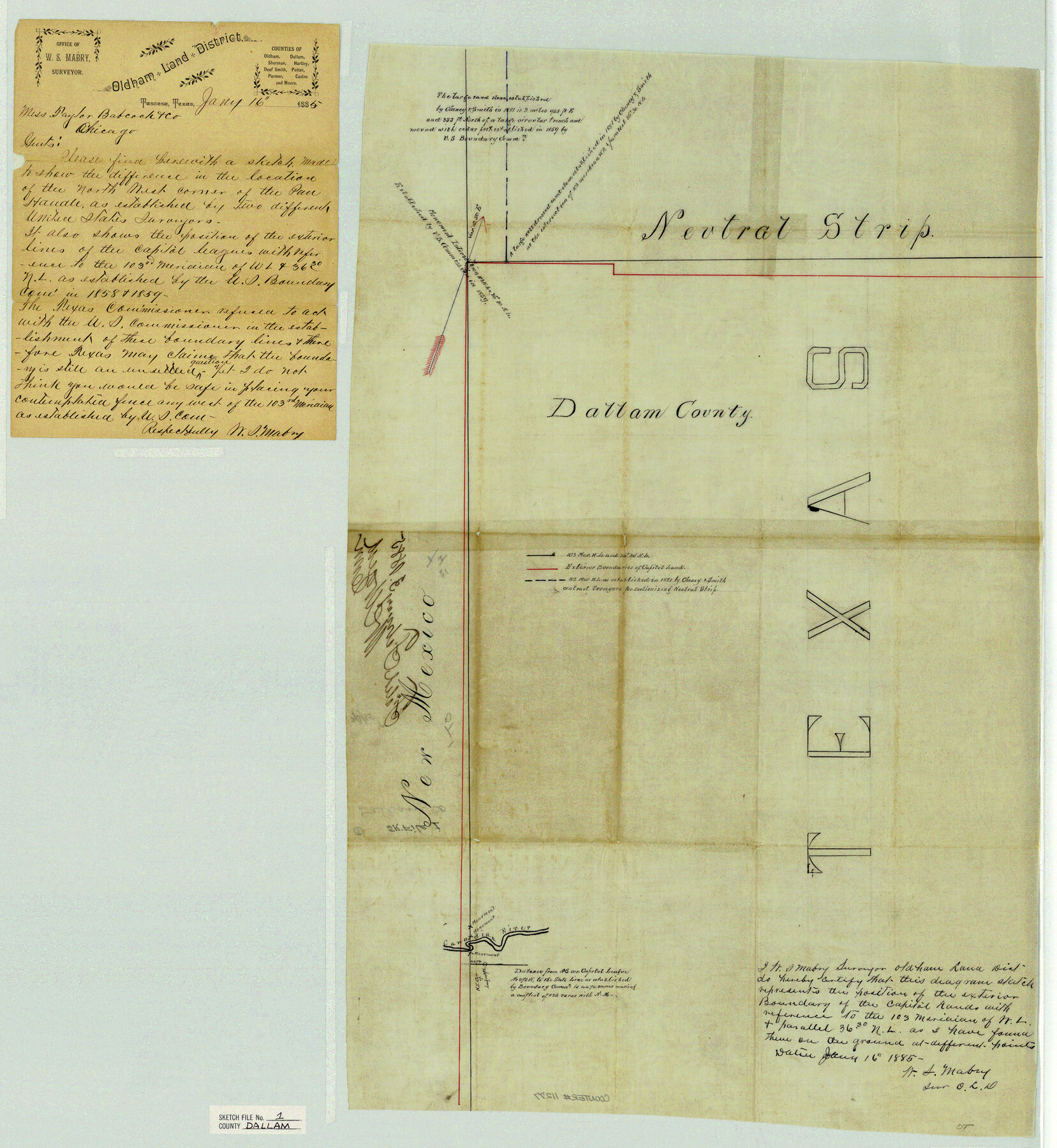
[Sketch to show the difference in the location of the northwest corner of the Panhandle as established by two different United States surveyors and also the position of the exterior lines of the Capitol Leagues with reference to the 103rd Meridian]
-
Map/Doc
11277
-
Collection
General Map Collection
-
Object Dates
1/16/1885 (Creation Date)
2/3/1885 (File Date)
-
People and Organizations
W.S. Mabry (Surveyor/Engineer)
-
Counties
Dallam
-
Subjects
Surveying Sketch File
-
Height x Width
29.5 x 27.1 inches
74.9 x 68.8 cm
-
Medium
paper, manuscript
-
Features
Canadian River
Part of: General Map Collection
Marion County Working Sketch 23

Print $20.00
- Digital $50.00
Marion County Working Sketch 23
1960
Size 24.4 x 25.9 inches
Map/Doc 70799
Kent County Working Sketch 13

Print $20.00
- Digital $50.00
Kent County Working Sketch 13
1963
Size 27.9 x 44.2 inches
Map/Doc 70020
Hays County Sketch File 15

Print $40.00
- Digital $50.00
Hays County Sketch File 15
1871
Size 12.0 x 16.6 inches
Map/Doc 26225
Schleicher County Rolled Sketch 19

Print $20.00
- Digital $50.00
Schleicher County Rolled Sketch 19
Size 25.0 x 21.9 inches
Map/Doc 7761
Van Zandt County Sketch File 16b

Print $2.00
- Digital $50.00
Van Zandt County Sketch File 16b
Size 12.8 x 8.3 inches
Map/Doc 39416
Culberson County Sketch File 5a

Print $44.00
- Digital $50.00
Culberson County Sketch File 5a
Size 14.2 x 8.8 inches
Map/Doc 20169
McMullen County Rolled Sketch 17

Print $40.00
- Digital $50.00
McMullen County Rolled Sketch 17
1950
Map/Doc 9501
Hardeman County Sketch File 12

Print $4.00
- Digital $50.00
Hardeman County Sketch File 12
Size 12.8 x 8.3 inches
Map/Doc 25020
Sutton County Sketch File 45

Print $4.00
- Digital $50.00
Sutton County Sketch File 45
1939
Size 11.2 x 8.6 inches
Map/Doc 37515
Map of Ferguson State Farm, Madison County, Texas

Print $20.00
- Digital $50.00
Map of Ferguson State Farm, Madison County, Texas
Size 21.6 x 26.1 inches
Map/Doc 62989
Scurry County Sketch File 4

Print $26.00
- Digital $50.00
Scurry County Sketch File 4
1881
Size 13.1 x 8.5 inches
Map/Doc 36565
Flight Mission No. DQO-7K, Frame 98, Galveston County

Print $20.00
- Digital $50.00
Flight Mission No. DQO-7K, Frame 98, Galveston County
1952
Size 18.8 x 22.4 inches
Map/Doc 85113
You may also like
Maverick County Rolled Sketch 20

Print $20.00
- Digital $50.00
Maverick County Rolled Sketch 20
Size 24.5 x 38.7 inches
Map/Doc 6712
[Boundary Survey of County]
![89735, [Boundary Survey of County], Twichell Survey Records](https://historictexasmaps.com/wmedia_w700/maps/89735-1.tif.jpg)
Print $40.00
- Digital $50.00
[Boundary Survey of County]
Size 64.9 x 37.0 inches
Map/Doc 89735
Cottle County Sketch File 18

Print $46.00
- Digital $50.00
Cottle County Sketch File 18
2004
Size 8.0 x 11.0 inches
Map/Doc 82433
Travis County Rolled Sketch 44

Print $20.00
- Digital $50.00
Travis County Rolled Sketch 44
Size 34.2 x 35.6 inches
Map/Doc 10052

Brazoria County Working Sketch 35

Print $40.00
- Digital $50.00
Brazoria County Working Sketch 35
1981
Size 43.5 x 66.2 inches
Map/Doc 67520
Lampasas County Rolled Sketch 2

Print $20.00
- Digital $50.00
Lampasas County Rolled Sketch 2
Size 21.0 x 39.2 inches
Map/Doc 6565

Val Verde County Rolled Sketch 51

Print $40.00
- Digital $50.00
Val Verde County Rolled Sketch 51
1937
Size 29.4 x 48.4 inches
Map/Doc 10075
Crockett County Sketch File 45

Print $14.00
- Digital $50.00
Crockett County Sketch File 45
Size 12.7 x 8.8 inches
Map/Doc 19772
Map showing lands surveyed by Sylvan Sanders in the Southwestern Part of Jack County, Texas for Buttram Petroleum Corporation

Print $20.00
- Digital $50.00
Map showing lands surveyed by Sylvan Sanders in the Southwestern Part of Jack County, Texas for Buttram Petroleum Corporation
Size 21.2 x 12.9 inches
Map/Doc 92186
Hemphill County Working Sketch 32

Print $20.00
- Digital $50.00
Hemphill County Working Sketch 32
1976
Size 45.8 x 34.2 inches
Map/Doc 66127