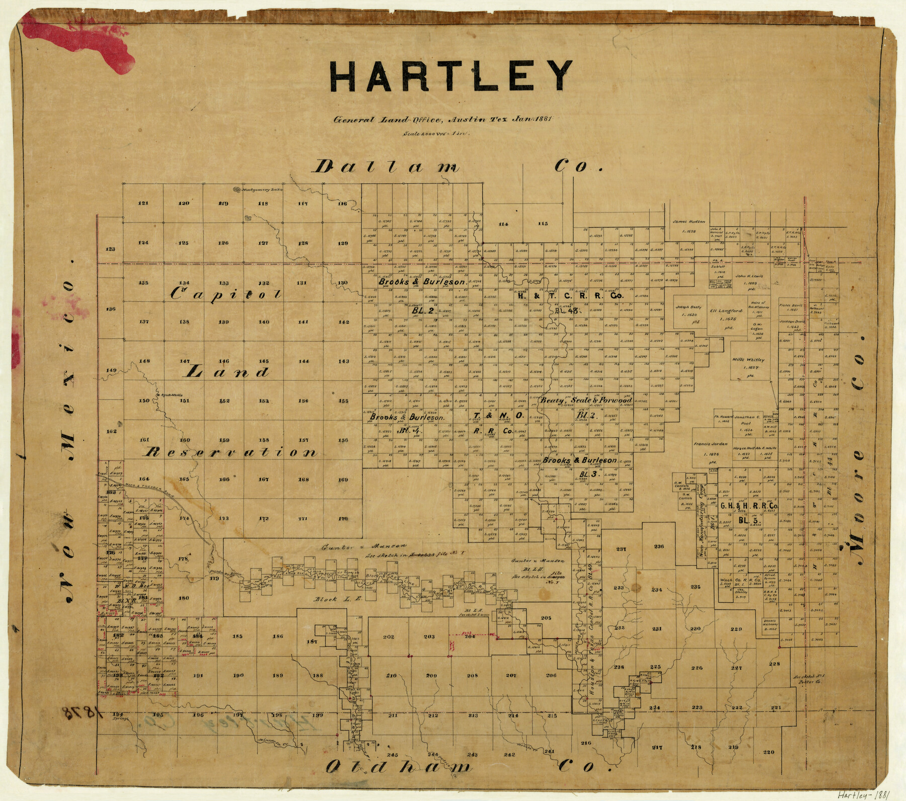
Hartley
-
Map/Doc
3640
-
Collection
General Map Collection
-
Object Dates
1/1881 (Creation Date)
-
Counties
Hartley
-
Subjects
County
-
Height x Width
25.4 x 28.4 inches
64.5 x 72.1 cm
-
Features
Montgomery Lake
Agua Medio
Agua Medio River
Moro and Tascosa Road
Punta de Agua River
Punta de Agua Creek
Agua Medio Creek
IRR
Mustang Creek
EL&RR
Minneosa Creek
Pedriza Creek
Moneto Creek
Romero Creek
Part of: General Map Collection
Webb County Working Sketch 16

Print $20.00
- Digital $50.00
Webb County Working Sketch 16
1923
Size 27.6 x 32.1 inches
Map/Doc 72381
La Salle County Sketch File 25

Print $4.00
- Digital $50.00
La Salle County Sketch File 25
Size 7.5 x 14.2 inches
Map/Doc 29549
Briscoe County Rolled Sketch 14B

Print $20.00
- Digital $50.00
Briscoe County Rolled Sketch 14B
1929
Size 32.6 x 37.3 inches
Map/Doc 8531
Dickens County Boundary File 4

Print $52.00
- Digital $50.00
Dickens County Boundary File 4
Size 14.2 x 8.7 inches
Map/Doc 52546
Improving Sabine Pass, Texas. Surveyed May 10th to June 30th, 1894 under the direction of Major James B. Quinn, Corps of Engineers, USA

Print $20.00
- Digital $50.00
Improving Sabine Pass, Texas. Surveyed May 10th to June 30th, 1894 under the direction of Major James B. Quinn, Corps of Engineers, USA
1894
Size 9.3 x 13.2 inches
Map/Doc 94155
Galveston County NRC Article 33.136 Sketch 37

Print $22.00
- Digital $50.00
Galveston County NRC Article 33.136 Sketch 37
2006
Size 36.6 x 25.1 inches
Map/Doc 83551
Midland County Working Sketch 3

Print $20.00
- Digital $50.00
Midland County Working Sketch 3
Size 19.5 x 35.2 inches
Map/Doc 70983
Flight Mission No. BRA-16M, Frame 111, Jefferson County

Print $20.00
- Digital $50.00
Flight Mission No. BRA-16M, Frame 111, Jefferson County
1953
Size 18.5 x 22.2 inches
Map/Doc 85721
Llano County Working Sketch 8

Print $20.00
- Digital $50.00
Llano County Working Sketch 8
1978
Size 33.4 x 30.7 inches
Map/Doc 70626
Menard County Boundary File 6

Print $6.00
- Digital $50.00
Menard County Boundary File 6
Size 11.2 x 8.7 inches
Map/Doc 57086
Real County Working Sketch 22

Print $20.00
- Digital $50.00
Real County Working Sketch 22
1945
Size 20.0 x 21.7 inches
Map/Doc 71914
Flight Mission No. DAH-9M, Frame 160, Orange County

Print $20.00
- Digital $50.00
Flight Mission No. DAH-9M, Frame 160, Orange County
1953
Size 18.4 x 22.2 inches
Map/Doc 86859
You may also like
Flight Mission No. CRC-3R, Frame 94, Chambers County

Print $20.00
- Digital $50.00
Flight Mission No. CRC-3R, Frame 94, Chambers County
1956
Size 18.5 x 22.3 inches
Map/Doc 84832
General Highway Map, Nolan County, Texas

Print $20.00
General Highway Map, Nolan County, Texas
1961
Size 19.3 x 25.0 inches
Map/Doc 79614
Map of Padre Island Showing Location of Zoning Districts

Print $20.00
- Digital $50.00
Map of Padre Island Showing Location of Zoning Districts
1971
Size 18.7 x 26.6 inches
Map/Doc 4808
Deaf Smith County Rolled Sketch 3

Print $20.00
- Digital $50.00
Deaf Smith County Rolled Sketch 3
Size 23.9 x 18.0 inches
Map/Doc 95707
Jefferson County Sketch File 23

Print $20.00
- Digital $50.00
Jefferson County Sketch File 23
Size 15.8 x 17.8 inches
Map/Doc 11871
[Sketch showing Blocks B-11, G and M-2 and 3, L, and 47, Sections 77-102]
![91733, [Sketch showing Blocks B-11, G and M-2 and 3, L, and 47, Sections 77-102], Twichell Survey Records](https://historictexasmaps.com/wmedia_w700/maps/91733-1.tif.jpg)
Print $20.00
- Digital $50.00
[Sketch showing Blocks B-11, G and M-2 and 3, L, and 47, Sections 77-102]
Size 25.4 x 18.8 inches
Map/Doc 91733
Flight Mission No. BQR-9K, Frame 43, Brazoria County

Print $20.00
- Digital $50.00
Flight Mission No. BQR-9K, Frame 43, Brazoria County
1952
Size 18.6 x 22.3 inches
Map/Doc 84047
Crockett County Working Sketch 61

Print $20.00
- Digital $50.00
Crockett County Working Sketch 61
1955
Size 36.5 x 33.2 inches
Map/Doc 68394
The State of Oklahoma

Print $20.00
- Digital $50.00
The State of Oklahoma
1916
Size 28.4 x 34.4 inches
Map/Doc 97104
Baylor County Sketch File 12g

Print $50.00
- Digital $50.00
Baylor County Sketch File 12g
Size 11.4 x 8.9 inches
Map/Doc 14170
Medina County Rolled Sketch 19

Print $40.00
- Digital $50.00
Medina County Rolled Sketch 19
1987
Size 45.1 x 57.8 inches
Map/Doc 9508
Hidalgo County Sketch File 9

Print $40.00
- Digital $50.00
Hidalgo County Sketch File 9
1904
Size 8.8 x 5.7 inches
Map/Doc 26409