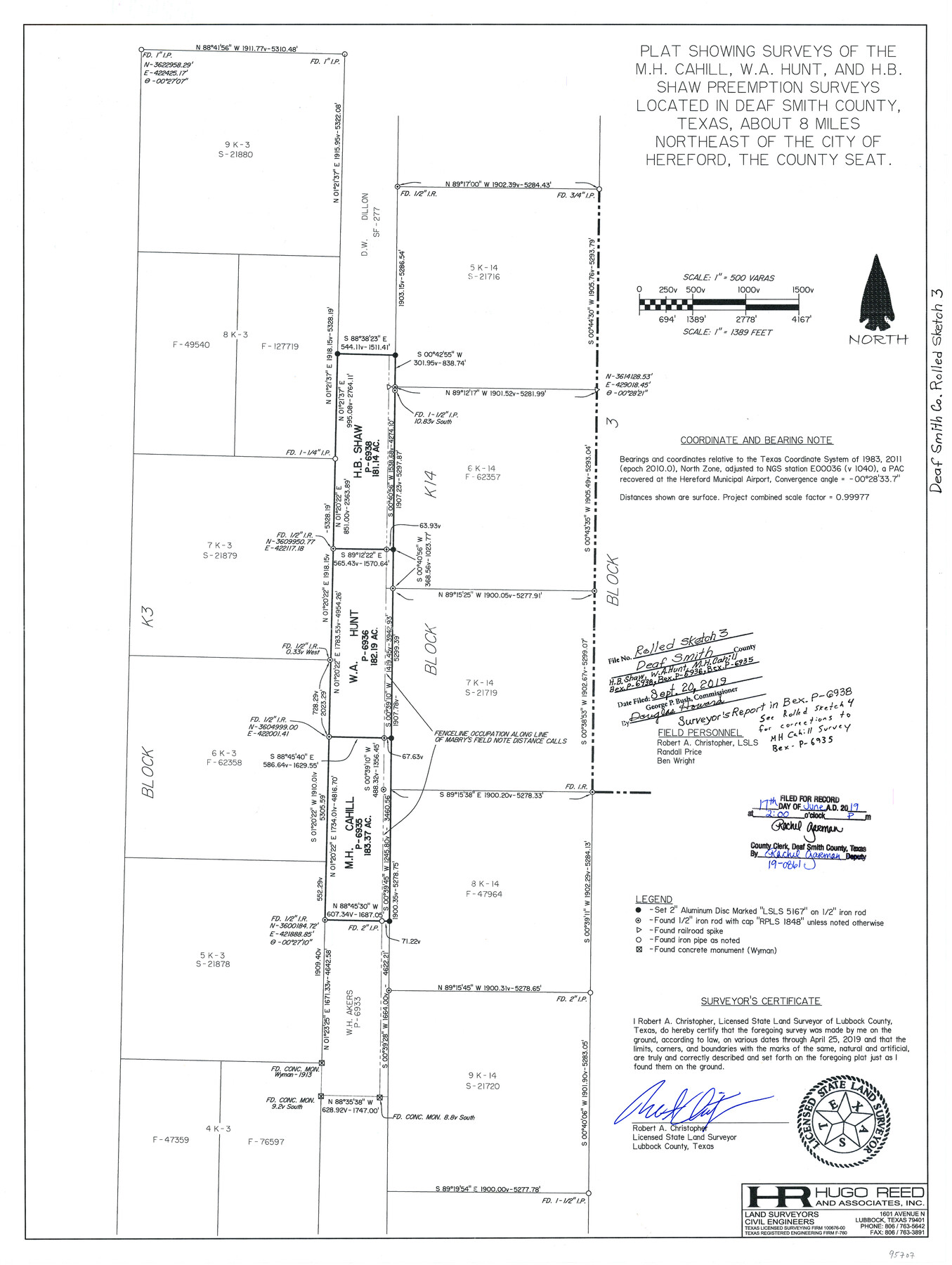
Deaf Smith County Rolled Sketch 3
Plat showing surveys of the M.H. Cahill, W.A. Hunt, and H.B. Shaw preemption surveys
-
Map/Doc
95707
-
Collection
General Map Collection
-
Object Dates
2019/4/25 (Survey Date)
2019/9/20 (File Date)
-
People and Organizations
Robert A. Christopher (Surveyor/Engineer)
Randall Price (Chainman/Field Personnel)
Ben Wright (Chainman/Field Personnel)
-
Counties
Deaf Smith
-
Subjects
Surveying Rolled Sketch
-
Height x Width
23.9 x 18.0 inches
60.7 x 45.7 cm
-
Medium
paper, print
-
Scale
1" = 500 varas
-
Comments
See Surveyor's Report in BEX P-6938. See Deaf Smith Rolled Sketch 4 (96789) for corrections to M.H. Cahill survey.
Related maps
Deaf Smith County Rolled Sketch 4

Print $20.00
- Digital $50.00
Deaf Smith County Rolled Sketch 4
Size 23.9 x 18.0 inches
Map/Doc 96789
Part of: General Map Collection
Galveston County NRC Article 33.136 Sketch 76

Print $26.00
- Digital $50.00
Galveston County NRC Article 33.136 Sketch 76
2014
Size 24.5 x 36.5 inches
Map/Doc 95125
Jones County Sketch File 1

Print $20.00
- Digital $50.00
Jones County Sketch File 1
1857
Size 17.8 x 30.3 inches
Map/Doc 11894
Crane County Rolled Sketch 15

Print $40.00
- Digital $50.00
Crane County Rolled Sketch 15
1946
Size 27.2 x 49.5 inches
Map/Doc 8682

[Gulf, Colorado & Santa Fe]
![64591, [Gulf, Colorado & Santa Fe], General Map Collection](https://historictexasmaps.com/wmedia_w700/maps/64591.tif.jpg)
Print $40.00
- Digital $50.00
[Gulf, Colorado & Santa Fe]
1918
Size 63.1 x 31.2 inches
Map/Doc 64591
Brewster County Working Sketch 60

Print $20.00
- Digital $50.00
Brewster County Working Sketch 60
1955
Size 22.3 x 18.2 inches
Map/Doc 67661
Flight Mission No. CRE-2R, Frame 165, Jackson County

Print $20.00
- Digital $50.00
Flight Mission No. CRE-2R, Frame 165, Jackson County
1956
Size 18.5 x 22.3 inches
Map/Doc 85375
Township No. 2 South Range No. 22 West of the Indian Meridian

Print $20.00
- Digital $50.00
Township No. 2 South Range No. 22 West of the Indian Meridian
1875
Size 19.2 x 24.3 inches
Map/Doc 75176
Eastland County Sketch File 14

Print $8.00
- Digital $50.00
Eastland County Sketch File 14
Size 11.5 x 9.2 inches
Map/Doc 21595
Galveston County Rolled Sketch 50

Print $20.00
- Digital $50.00
Galveston County Rolled Sketch 50
2011
Size 23.9 x 35.8 inches
Map/Doc 95179
Ector County Working Sketch 21

Print $40.00
- Digital $50.00
Ector County Working Sketch 21
Size 41.3 x 117.7 inches
Map/Doc 68864
Duval County Rolled Sketch 28

Print $20.00
- Digital $50.00
Duval County Rolled Sketch 28
1947
Size 15.9 x 23.7 inches
Map/Doc 5745
You may also like
Trinity River, Crabtree Ferry Sheet

Print $20.00
- Digital $50.00
Trinity River, Crabtree Ferry Sheet
1922
Size 41.9 x 37.8 inches
Map/Doc 65186
Camp County Working Sketch 2

Print $20.00
- Digital $50.00
Camp County Working Sketch 2
1975
Size 24.8 x 24.5 inches
Map/Doc 67878
Flight Mission No. CRK-5P, Frame 161, Refugio County

Print $20.00
- Digital $50.00
Flight Mission No. CRK-5P, Frame 161, Refugio County
1956
Size 18.5 x 22.4 inches
Map/Doc 86942
Brewster County Rolled Sketch 93

Print $20.00
- Digital $50.00
Brewster County Rolled Sketch 93
1935
Size 24.1 x 43.1 inches
Map/Doc 5251
Atlantic Coast to the Rocky Mountains

Atlantic Coast to the Rocky Mountains
1956
Size 42.5 x 29.4 inches
Map/Doc 94409
El Paso County Boundary File 25

Print $10.00
- Digital $50.00
El Paso County Boundary File 25
Size 13.0 x 8.9 inches
Map/Doc 53226
Foard County Sketch File X

Print $20.00
- Digital $50.00
Foard County Sketch File X
1882
Size 15.8 x 17.3 inches
Map/Doc 11499
Flight Mission No. BRA-9M, Frame 77, Jefferson County

Print $20.00
- Digital $50.00
Flight Mission No. BRA-9M, Frame 77, Jefferson County
1953
Size 18.5 x 22.4 inches
Map/Doc 85660
Comanche County Working Sketch 29

Print $20.00
- Digital $50.00
Comanche County Working Sketch 29
1986
Size 29.3 x 37.8 inches
Map/Doc 68163
Flight Mission No. DQO-13T, Frame 48, Galveston County

Print $20.00
- Digital $50.00
Flight Mission No. DQO-13T, Frame 48, Galveston County
1958
Size 18.5 x 18.2 inches
Map/Doc 85212
Crosby County Working Sketch 7

Print $20.00
- Digital $50.00
Crosby County Working Sketch 7
1938
Size 33.8 x 21.6 inches
Map/Doc 68441
