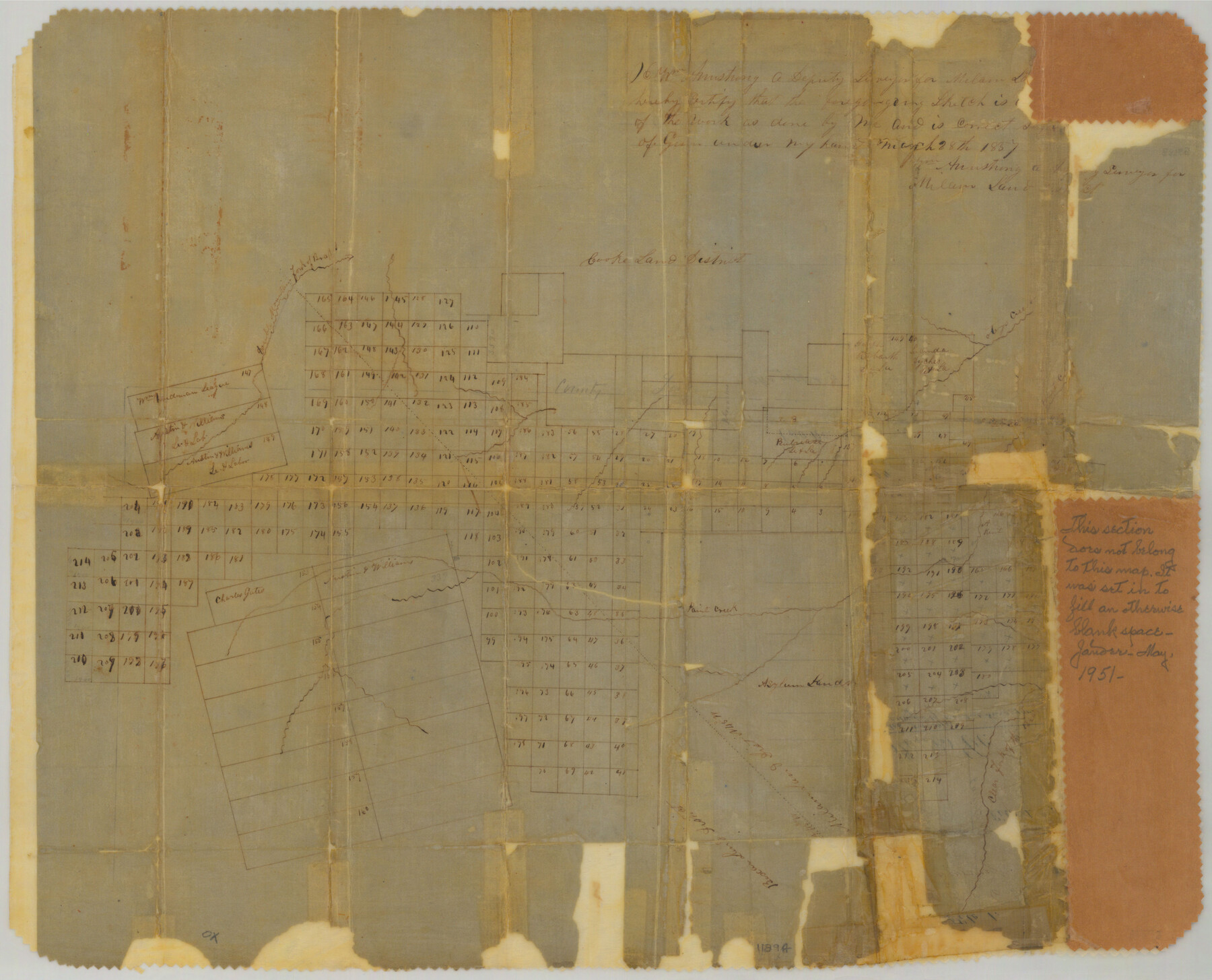
Jones County Sketch File 1
Cooke Land District
-
Map/Doc
11894
-
Collection
General Map Collection
-
Object Dates
3/28/1857 (Creation Date)
2/24/1858 (File Date)
-
People and Organizations
William Armstrong (Surveyor/Engineer)
-
Counties
Jones Fisher Stonewall Haskell Shackelford
-
Subjects
Surveying Sketch File
-
Height x Width
17.8 x 30.3 inches
45.2 x 77.0 cm
-
Medium
paper, manuscript
-
Features
Otery's Creek
Double Mountain Fork of Brazos River
Paint Creek
Clear Fork of the Brazos River
Part of: General Map Collection
Flight Mission No. CON-4R, Frame 200, Stonewall County

Print $20.00
- Digital $50.00
Flight Mission No. CON-4R, Frame 200, Stonewall County
1957
Size 18.2 x 22.0 inches
Map/Doc 86994
Burnet County Sketch File 30

Print $4.00
- Digital $50.00
Burnet County Sketch File 30
Size 11.0 x 8.0 inches
Map/Doc 16746
Knox County Working Sketch 20

Print $20.00
- Digital $50.00
Knox County Working Sketch 20
2012
Size 40.2 x 36.9 inches
Map/Doc 93389
Mineral Plats - Brewster, Culberson and Duval

Mineral Plats - Brewster, Culberson and Duval
Map/Doc 81745
Potter County Boundary File 1b

Print $8.00
- Digital $50.00
Potter County Boundary File 1b
Size 14.4 x 8.4 inches
Map/Doc 57948
Webb County Working Sketch 86

Print $20.00
- Digital $50.00
Webb County Working Sketch 86
1981
Size 44.3 x 37.0 inches
Map/Doc 72453
Gregg County Rolled Sketch 12

Print $40.00
- Digital $50.00
Gregg County Rolled Sketch 12
1939
Size 49.5 x 55.5 inches
Map/Doc 9065
Bandera County

Print $40.00
- Digital $50.00
Bandera County
1904
Size 30.7 x 61.0 inches
Map/Doc 3274
Nueces County Working Sketch 9

Print $20.00
- Digital $50.00
Nueces County Working Sketch 9
1977
Size 36.1 x 24.1 inches
Map/Doc 71311
McMullen County Working Sketch 43

Print $20.00
- Digital $50.00
McMullen County Working Sketch 43
1980
Size 35.2 x 28.1 inches
Map/Doc 70744
Topographical Map of the Rio Grande, Sheet No. 10

Print $20.00
- Digital $50.00
Topographical Map of the Rio Grande, Sheet No. 10
1912
Map/Doc 89534
Wise County Sketch File 34

Print $6.00
- Digital $50.00
Wise County Sketch File 34
1856
Size 6.3 x 9.6 inches
Map/Doc 40592
You may also like
Crockett County Sketch File D

Print $40.00
- Digital $50.00
Crockett County Sketch File D
1903
Size 24.6 x 48.0 inches
Map/Doc 10347
[Blocks in East Floyd County and West Motley County showing Blocks D2, D3, GM, GP and T]
![92113, [Blocks in East Floyd County and West Motley County showing Blocks D2, D3, GM, GP and T], Twichell Survey Records](https://historictexasmaps.com/wmedia_w700/maps/92113-1.tif.jpg)
Print $20.00
- Digital $50.00
[Blocks in East Floyd County and West Motley County showing Blocks D2, D3, GM, GP and T]
Size 22.2 x 10.9 inches
Map/Doc 92113
Double Lakes No. 2, T-Ranch

Print $20.00
- Digital $50.00
Double Lakes No. 2, T-Ranch
Size 19.9 x 20.3 inches
Map/Doc 92894
Flight Mission No. CLL-1N, Frame 76, Willacy County

Print $20.00
- Digital $50.00
Flight Mission No. CLL-1N, Frame 76, Willacy County
1954
Size 18.3 x 22.0 inches
Map/Doc 87022
Brooks County Sketch File 8

Print $40.00
- Digital $50.00
Brooks County Sketch File 8
1946
Size 26.5 x 38.4 inches
Map/Doc 11018
Flight Mission No. DQN-2K, Frame 31, Calhoun County

Print $20.00
- Digital $50.00
Flight Mission No. DQN-2K, Frame 31, Calhoun County
1953
Size 18.7 x 22.3 inches
Map/Doc 84238
Brazoria County Rolled Sketch 34

Print $20.00
- Digital $50.00
Brazoria County Rolled Sketch 34
1944
Size 29.8 x 18.3 inches
Map/Doc 5171
General Topographical Map. Sheet XXII

Print $20.00
- Digital $50.00
General Topographical Map. Sheet XXII
1891
Size 18.4 x 29.4 inches
Map/Doc 97526
[Location Survey of the Southern Kansas Railway, Kiowa Extension from a point in Drake's Location, in Indian Territory 100 miles from south line of Kansas, continuing up Wolf Creek and South Canadian River to Cottonwood Creek in Hutchinson County]
![88841, [Location Survey of the Southern Kansas Railway, Kiowa Extension from a point in Drake's Location, in Indian Territory 100 miles from south line of Kansas, continuing up Wolf Creek and South Canadian River to Cottonwood Creek in Hutchinson County], General Map Collection](https://historictexasmaps.com/wmedia_w700/maps/88841.tif.jpg)
Print $20.00
- Digital $50.00
[Location Survey of the Southern Kansas Railway, Kiowa Extension from a point in Drake's Location, in Indian Territory 100 miles from south line of Kansas, continuing up Wolf Creek and South Canadian River to Cottonwood Creek in Hutchinson County]
1886
Size 39.1 x 42.0 inches
Map/Doc 88841
Gregg County Sketch File 10

Print $20.00
- Digital $50.00
Gregg County Sketch File 10
1932
Size 35.1 x 26.0 inches
Map/Doc 11588
Reeves County Working Sketch 64

Print $20.00
- Digital $50.00
Reeves County Working Sketch 64
1984
Size 26.3 x 26.5 inches
Map/Doc 63507
Stonewall County Rolled Sketch 17

Print $20.00
- Digital $50.00
Stonewall County Rolled Sketch 17
1927
Size 20.1 x 30.2 inches
Map/Doc 7871