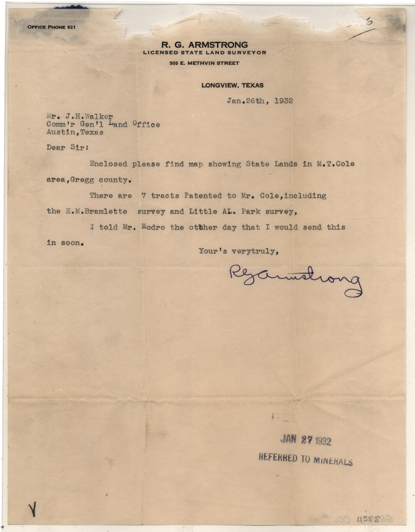
Gregg County Sketch File 10
Sketch of lands owned by M. T. Cole, Gregg County
-
Map/Doc
11588
-
Collection
General Map Collection
-
Object Dates
1932/1/27 (File Date)
1932/1/26 (Creation Date)
-
People and Organizations
R.G. Armstrong (Surveyor/Engineer)
-
Counties
Gregg
-
Subjects
Surveying Sketch File
-
Height x Width
35.1 x 26.0 inches
89.2 x 66.0 cm
-
Medium
multi-page, multi-format
-
Features
Sabine River
Prarie [sic] Creek
Rocky Creek
Part of: General Map Collection
Clay County Sketch File 22

Print $6.00
- Digital $50.00
Clay County Sketch File 22
Size 12.8 x 8.3 inches
Map/Doc 18436
Waller County Sketch File 11

Print $40.00
- Digital $50.00
Waller County Sketch File 11
1913
Size 16.6 x 14.3 inches
Map/Doc 39614
Frio County Sketch File 5

Print $4.00
- Digital $50.00
Frio County Sketch File 5
1878
Size 7.9 x 11.2 inches
Map/Doc 23116
Map of Caldwell County

Print $20.00
- Digital $50.00
Map of Caldwell County
1871
Size 16.9 x 19.8 inches
Map/Doc 4590
Henderson County Working Sketch 16

Print $40.00
- Digital $50.00
Henderson County Working Sketch 16
1937
Size 49.9 x 30.9 inches
Map/Doc 66149
Flight Mission No. CUG-3P, Frame 41, Kleberg County

Print $20.00
- Digital $50.00
Flight Mission No. CUG-3P, Frame 41, Kleberg County
1956
Size 18.3 x 22.1 inches
Map/Doc 86246
Tyler County Sketch File 1

Print $22.00
- Digital $50.00
Tyler County Sketch File 1
1849
Size 12.2 x 15.3 inches
Map/Doc 38607
Map of Port Bolivar

Print $20.00
- Digital $50.00
Map of Port Bolivar
1893
Size 24.9 x 18.5 inches
Map/Doc 2191
United States - Gulf Coast - Galveston to Rio Grande

Print $20.00
- Digital $50.00
United States - Gulf Coast - Galveston to Rio Grande
1940
Size 27.1 x 18.2 inches
Map/Doc 72758
Grayson County Working Sketch 23

Print $20.00
- Digital $50.00
Grayson County Working Sketch 23
1976
Size 18.6 x 24.3 inches
Map/Doc 63262
Stonewall County Working Sketch 27

Print $20.00
- Digital $50.00
Stonewall County Working Sketch 27
1976
Size 20.7 x 29.9 inches
Map/Doc 62334
Harris County Rolled Sketch 80

Print $20.00
- Digital $50.00
Harris County Rolled Sketch 80
1958
Size 31.1 x 31.0 inches
Map/Doc 6116
You may also like
Runnels County Sketch File 29

Print $20.00
Runnels County Sketch File 29
1950
Size 23.8 x 18.0 inches
Map/Doc 12261
Aransas County Sketch File 24a

Print $42.00
- Digital $50.00
Aransas County Sketch File 24a
1941
Size 11.6 x 8.6 inches
Map/Doc 13195
Flight Mission No. DQN-6K, Frame 68, Calhoun County

Print $20.00
- Digital $50.00
Flight Mission No. DQN-6K, Frame 68, Calhoun County
1953
Size 18.5 x 22.1 inches
Map/Doc 84440
Val Verde County Boundary File 2

Print $4.00
- Digital $50.00
Val Verde County Boundary File 2
Size 11.4 x 8.8 inches
Map/Doc 59575
[Panhandle Counties]
![90796, [Panhandle Counties], Twichell Survey Records](https://historictexasmaps.com/wmedia_w700/maps/90796-1.tif.jpg)
Print $20.00
- Digital $50.00
[Panhandle Counties]
1908
Size 18.4 x 14.8 inches
Map/Doc 90796
Armstrong County Working Sketch 11

Print $20.00
- Digital $50.00
Armstrong County Working Sketch 11
2025
Size 24.7 x 36.5 inches
Map/Doc 97507
Hutchinson County Working Sketch 4

Print $20.00
- Digital $50.00
Hutchinson County Working Sketch 4
1907
Size 25.0 x 23.4 inches
Map/Doc 66362
Medina County Sketch File 18

Print $40.00
- Digital $50.00
Medina County Sketch File 18
Size 23.1 x 10.5 inches
Map/Doc 31482
Map of Hays County

Print $20.00
- Digital $50.00
Map of Hays County
1877
Size 21.2 x 19.8 inches
Map/Doc 3646
Webb County Sketch File 9

Print $25.00
- Digital $50.00
Webb County Sketch File 9
1870
Size 9.5 x 8.5 inches
Map/Doc 39761
Val Verde County Working Sketch 12

Print $20.00
- Digital $50.00
Val Verde County Working Sketch 12
1920
Size 29.0 x 24.3 inches
Map/Doc 72147
Upshur County Rolled Sketch 5

Print $20.00
- Digital $50.00
Upshur County Rolled Sketch 5
2000
Size 35.2 x 24.4 inches
Map/Doc 8064