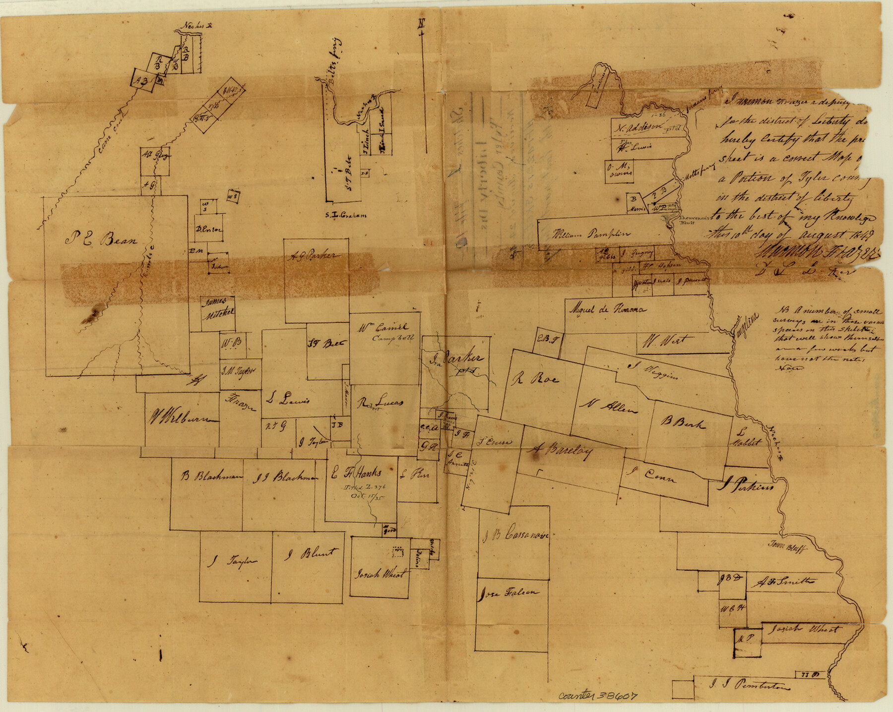
Tyler County Sketch File 1
[Sketch of surveys in the north half of the county]
-
Map/Doc
38607
-
Collection
General Map Collection
-
Object Dates
8/10/1849 (Creation Date)
8/24/1849 (File Date)
-
People and Organizations
Harmon Frazer (Surveyor/Engineer)
-
Counties
Tyler
-
Subjects
Surveying Sketch File
-
Height x Width
12.2 x 15.3 inches
31.0 x 38.9 cm
-
Medium
paper, manuscript
-
Features
Neches River
Cane Creek
Belts Ferry
Jordan's Ferry
Motts Ferry
Theuvenon's Bluff
Russell's Creek
Part of: General Map Collection
Jefferson County Working Sketch 10

Print $40.00
- Digital $50.00
Jefferson County Working Sketch 10
1942
Size 35.0 x 49.4 inches
Map/Doc 66553
Map of Leon County

Print $20.00
- Digital $50.00
Map of Leon County
1871
Size 25.4 x 23.2 inches
Map/Doc 4579
Lamar County Sketch File 2

Print $4.00
- Digital $50.00
Lamar County Sketch File 2
1859
Size 12.1 x 7.5 inches
Map/Doc 29273

Flight Mission No. DQN-1K, Frame 42, Calhoun County

Print $20.00
- Digital $50.00
Flight Mission No. DQN-1K, Frame 42, Calhoun County
1953
Size 18.5 x 18.7 inches
Map/Doc 84142
Nueces County Rolled Sketch 44

Print $40.00
- Digital $50.00
Nueces County Rolled Sketch 44
1948
Size 40.0 x 60.8 inches
Map/Doc 9602
Martin County Rolled Sketch 4

Print $20.00
- Digital $50.00
Martin County Rolled Sketch 4
1908
Size 40.9 x 24.8 inches
Map/Doc 6665
Galveston County Working Sketch 6

Print $20.00
- Digital $50.00
Galveston County Working Sketch 6
1934
Size 43.5 x 38.0 inches
Map/Doc 69343
Flight Mission No. DQN-5K, Frame 33, Calhoun County

Print $20.00
- Digital $50.00
Flight Mission No. DQN-5K, Frame 33, Calhoun County
1953
Size 18.5 x 22.3 inches
Map/Doc 84384
Brooks County Sketch File 3b

Print $12.00
- Digital $50.00
Brooks County Sketch File 3b
1939
Size 14.3 x 9.1 inches
Map/Doc 16544
Map of Louisiana from D'Anville's Atlas

Print $20.00
- Digital $50.00
Map of Louisiana from D'Anville's Atlas
1788
Size 16.7 x 21.6 inches
Map/Doc 94111
Duval County Sketch File 79

Print $46.00
- Digital $50.00
Duval County Sketch File 79
1925
Size 14.3 x 9.1 inches
Map/Doc 21469
You may also like
Flight Mission No. DAG-24K, Frame 51, Matagorda County

Print $20.00
- Digital $50.00
Flight Mission No. DAG-24K, Frame 51, Matagorda County
1953
Size 16.0 x 15.9 inches
Map/Doc 86538
Outer Continental Shelf Leasing Maps (Louisiana Offshore Operations)

Print $20.00
- Digital $50.00
Outer Continental Shelf Leasing Maps (Louisiana Offshore Operations)
1955
Size 14.0 x 12.8 inches
Map/Doc 76085
[Galveston, Harrisburg & San Antonio Railroad from Cuero to Stockdale]
![64193, [Galveston, Harrisburg & San Antonio Railroad from Cuero to Stockdale], General Map Collection](https://historictexasmaps.com/wmedia_w700/maps/64193.tif.jpg)
Print $20.00
- Digital $50.00
[Galveston, Harrisburg & San Antonio Railroad from Cuero to Stockdale]
1907
Size 13.7 x 34.0 inches
Map/Doc 64193
Eastland County Working Sketch 30

Print $20.00
- Digital $50.00
Eastland County Working Sketch 30
1954
Size 20.2 x 24.0 inches
Map/Doc 68811
Current Miscellaneous File 35

Print $10.00
- Digital $50.00
Current Miscellaneous File 35
Size 14.2 x 8.7 inches
Map/Doc 73947
Supreme Court of the United States, October Term, 1924, No. 13, Original - The State of Oklahoma, Complainant vs. The State of Texas, Defendant, The United States, Intervener

Print $20.00
- Digital $50.00
Supreme Court of the United States, October Term, 1924, No. 13, Original - The State of Oklahoma, Complainant vs. The State of Texas, Defendant, The United States, Intervener
1924
Size 32.0 x 32.8 inches
Map/Doc 75132

Map of the Lands Surveyed by the Memphis, El Paso & Pacific R.R. Company

Print $20.00
- Digital $50.00
Map of the Lands Surveyed by the Memphis, El Paso & Pacific R.R. Company
1860
Size 17.7 x 21.7 inches
Map/Doc 4851
Maverick County Working Sketch 9

Print $20.00
- Digital $50.00
Maverick County Working Sketch 9
1959
Size 43.8 x 42.2 inches
Map/Doc 70901
Reeves County Working Sketch 57

Print $40.00
- Digital $50.00
Reeves County Working Sketch 57
1978
Size 58.3 x 35.8 inches
Map/Doc 63500
Map of Comal County

Print $20.00
- Digital $50.00
Map of Comal County
1862
Size 18.6 x 22.0 inches
Map/Doc 3429
J. De Cordova's Map of the State of Texas Compiled from the records of the General Land Office of the State

Print $20.00
J. De Cordova's Map of the State of Texas Compiled from the records of the General Land Office of the State
1849
Size 35.7 x 33.6 inches
Map/Doc 93964