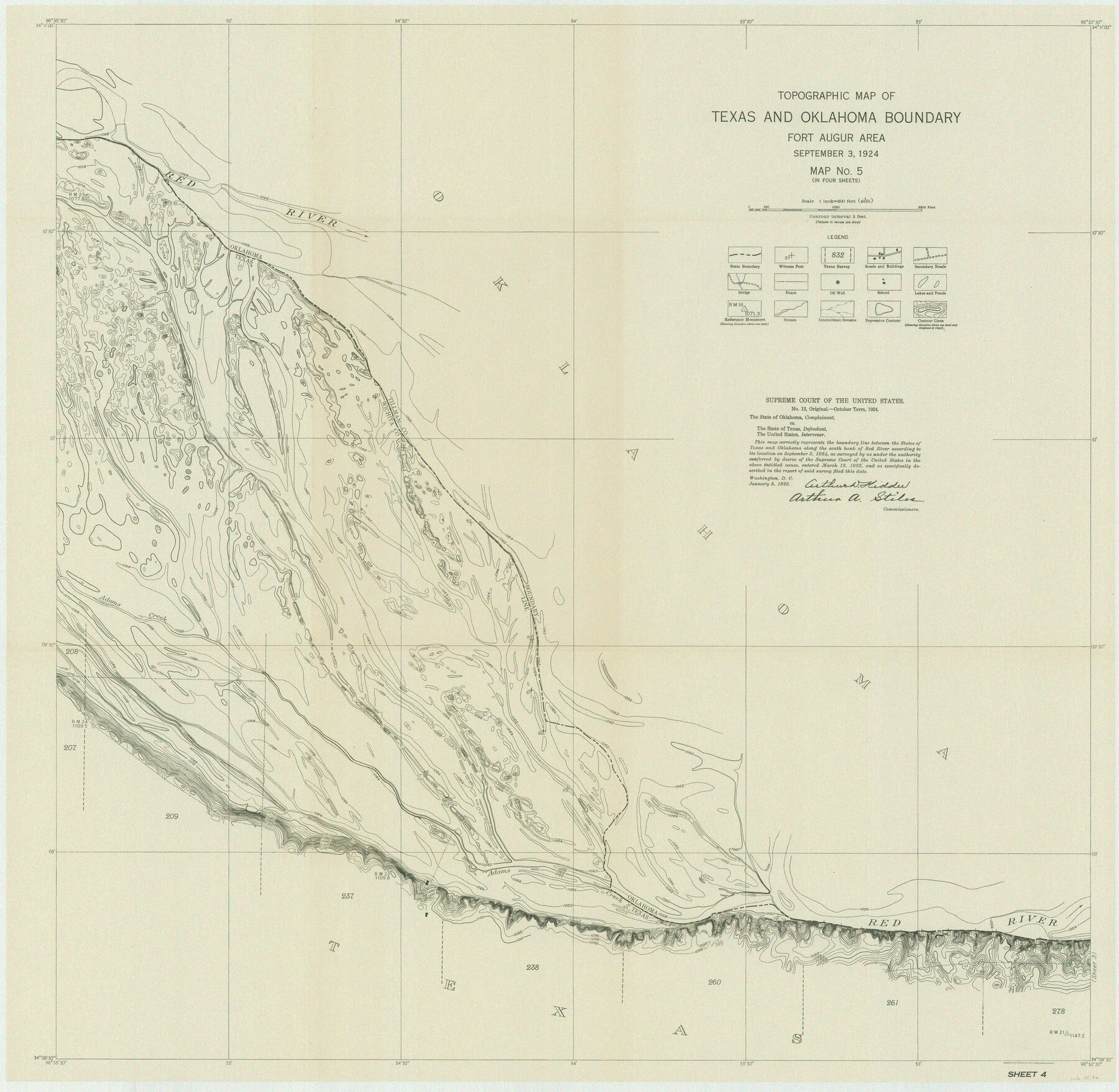
Supreme Court of the United States, October Term, 1924, No. 13, Original - The State of Oklahoma, Complainant vs. The State of Texas, Defendant, The United States, Intervener
-
Map/Doc
75132
-
Collection
General Map Collection
-
Object Dates
1924/9/23 (Creation Date)
-
Subjects
Texas Boundaries Topographic
-
Height x Width
32.0 x 32.8 inches
81.3 x 83.3 cm
Part of: General Map Collection
Flight Mission No. BQR-7K, Frame 32, Brazoria County

Print $20.00
- Digital $50.00
Flight Mission No. BQR-7K, Frame 32, Brazoria County
1952
Size 18.6 x 22.2 inches
Map/Doc 84030
Cooke County Sketch File 27

Print $24.00
- Digital $50.00
Cooke County Sketch File 27
Size 9.8 x 8.5 inches
Map/Doc 19279
Flight Mission No. CLL-1N, Frame 193, Willacy County

Print $20.00
- Digital $50.00
Flight Mission No. CLL-1N, Frame 193, Willacy County
1954
Size 18.4 x 22.2 inches
Map/Doc 87063
[Sketch for Mineral Application 24072, San Jacinto River]
![65593, [Sketch for Mineral Application 24072, San Jacinto River], General Map Collection](https://historictexasmaps.com/wmedia_w700/maps/65593.tif.jpg)
Print $20.00
- Digital $50.00
[Sketch for Mineral Application 24072, San Jacinto River]
1929
Size 19.1 x 16.9 inches
Map/Doc 65593
El Paso County Rolled Sketch 43B

Print $20.00
- Digital $50.00
El Paso County Rolled Sketch 43B
Size 22.0 x 22.0 inches
Map/Doc 5830
Hutchinson County Rolled Sketch 42

Print $40.00
- Digital $50.00
Hutchinson County Rolled Sketch 42
Size 38.0 x 49.5 inches
Map/Doc 6307
Flight Mission No. DQN-2K, Frame 72, Calhoun County

Print $20.00
- Digital $50.00
Flight Mission No. DQN-2K, Frame 72, Calhoun County
1953
Size 18.6 x 22.3 inches
Map/Doc 84264
Aransas County Rolled Sketch 27A

Print $2.00
- Digital $50.00
Aransas County Rolled Sketch 27A
1930
Size 8.9 x 7.2 inches
Map/Doc 5058
Map of Jack County

Print $40.00
- Digital $50.00
Map of Jack County
1895
Size 49.7 x 37.2 inches
Map/Doc 16858
El Paso County Working Sketch 34

Print $40.00
- Digital $50.00
El Paso County Working Sketch 34
1974
Size 53.4 x 34.7 inches
Map/Doc 69056
Denton County Working Sketch 6

Print $20.00
- Digital $50.00
Denton County Working Sketch 6
1958
Size 21.3 x 33.0 inches
Map/Doc 68611

You may also like
Texas-United States Boundary Line 2

Print $22.00
- Digital $50.00
Texas-United States Boundary Line 2
1882
Size 8.3 x 7.3 inches
Map/Doc 74976
Flight Mission No. BRE-2P, Frame 40, Nueces County

Print $20.00
- Digital $50.00
Flight Mission No. BRE-2P, Frame 40, Nueces County
1956
Size 18.4 x 22.4 inches
Map/Doc 86742
Reeves County Working Sketch 18

Print $20.00
- Digital $50.00
Reeves County Working Sketch 18
1961
Size 24.7 x 40.2 inches
Map/Doc 63461
Subdivision of the W.W. Arrington Tract situated 3 miles west of Clinton in DeWitt County, Texas owned by Hugh F. McKenna, Esqr., New Orleans

Print $20.00
- Digital $50.00
Subdivision of the W.W. Arrington Tract situated 3 miles west of Clinton in DeWitt County, Texas owned by Hugh F. McKenna, Esqr., New Orleans
Size 23.6 x 16.7 inches
Map/Doc 94242
Map of Armstrong County

Print $20.00
- Digital $50.00
Map of Armstrong County
1881
Size 25.8 x 19.9 inches
Map/Doc 3243
Map of Navarro County

Print $20.00
- Digital $50.00
Map of Navarro County
1858
Size 19.3 x 25.8 inches
Map/Doc 3912
Schleicher County Sketch File 27

Print $20.00
- Digital $50.00
Schleicher County Sketch File 27
Size 23.0 x 19.2 inches
Map/Doc 12305
Traveller's Map of the State of Texas

Print $20.00
- Digital $50.00
Traveller's Map of the State of Texas
1867
Size 40.6 x 38.2 inches
Map/Doc 4327
Galveston - Texas City, Texas

Galveston - Texas City, Texas
2008
Size 26.9 x 39.0 inches
Map/Doc 96858
Harris County Sketch File 19

Print $4.00
- Digital $50.00
Harris County Sketch File 19
1862
Size 8.7 x 13.9 inches
Map/Doc 25366
Map of a Part of Lea County, New Mexico

Print $40.00
- Digital $50.00
Map of a Part of Lea County, New Mexico
Size 60.5 x 42.0 inches
Map/Doc 89910
Rhyne Simpson Addition No. 2, City of Lubbock Section 3, Block O

Print $20.00
- Digital $50.00
Rhyne Simpson Addition No. 2, City of Lubbock Section 3, Block O
1951
Size 12.2 x 18.4 inches
Map/Doc 92731