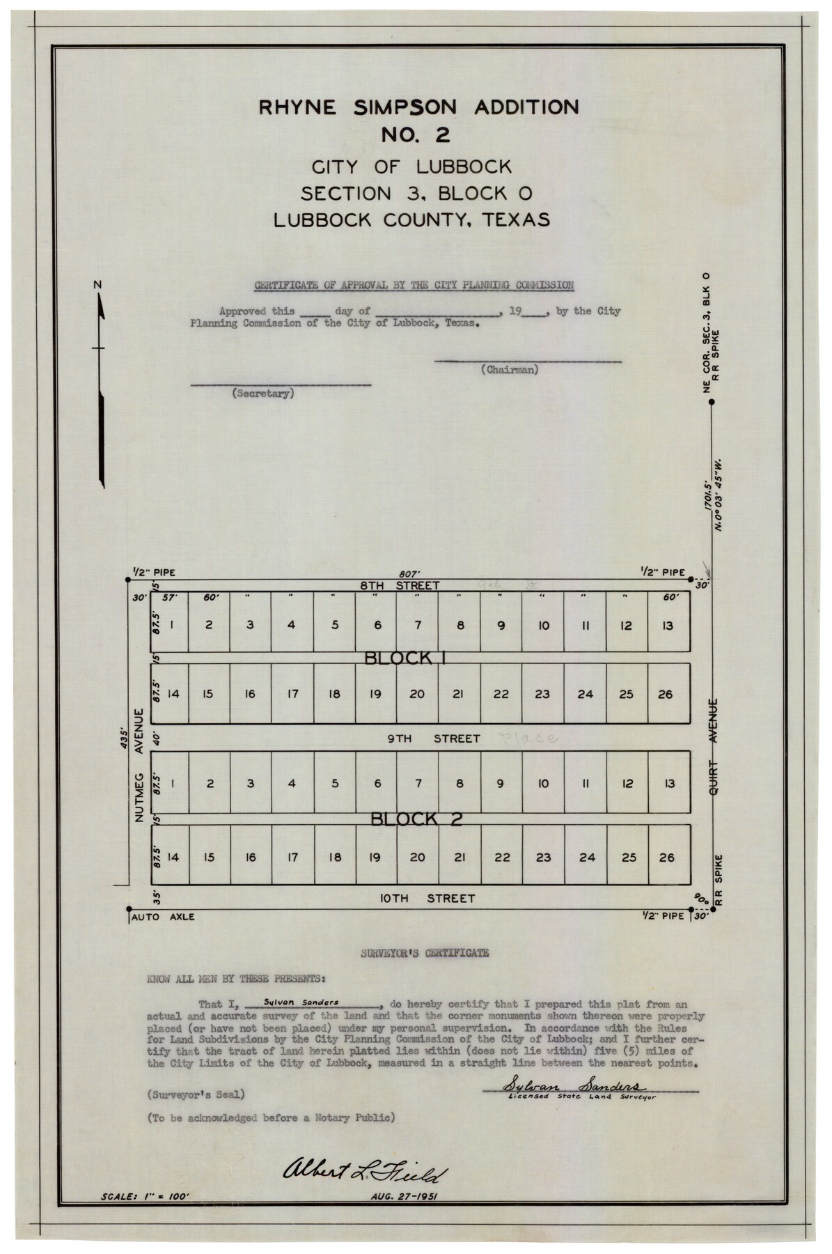
Rhyne Simpson Addition No. 2, City of Lubbock Section 3, Block O
-
Map/Doc
92731
-
Collection
Twichell Survey Records
-
Object Dates
8/27/1951 (Creation Date)
-
People and Organizations
Sylvan Sanders (Surveyor/Engineer)
-
Counties
Lubbock
-
Height x Width
12.2 x 18.4 inches
31.0 x 46.7 cm
Part of: Twichell Survey Records
[Map Showing J. H. Kemble Sections]
![92893, [Map Showing J. H. Kemble Sections], Twichell Survey Records](https://historictexasmaps.com/wmedia_w700/maps/92893-1.tif.jpg)
Print $20.00
- Digital $50.00
[Map Showing J. H. Kemble Sections]
Size 17.8 x 22.3 inches
Map/Doc 92893
N. C. Payne Land in Lamb and Hale Counties]
![91060, N. C. Payne Land in Lamb and Hale Counties], Twichell Survey Records](https://historictexasmaps.com/wmedia_w700/maps/91060-1.tif.jpg)
Print $20.00
- Digital $50.00
N. C. Payne Land in Lamb and Hale Counties]
Size 18.6 x 23.9 inches
Map/Doc 91060
General Highway Map Hockley County, Texas

Print $20.00
- Digital $50.00
General Highway Map Hockley County, Texas
1949
Size 25.7 x 18.8 inches
Map/Doc 92209
[Sketch showing part of Blk. M6]
![89642, [Sketch showing part of Blk. M6], Twichell Survey Records](https://historictexasmaps.com/wmedia_w700/maps/89642-1.tif.jpg)
Print $40.00
- Digital $50.00
[Sketch showing part of Blk. M6]
1913
Size 64.8 x 30.3 inches
Map/Doc 89642
[School Leagues in Bailey and Lamb County]
![90987, [School Leagues in Bailey and Lamb County], Twichell Survey Records](https://historictexasmaps.com/wmedia_w700/maps/90987-2.tif.jpg)
Print $20.00
- Digital $50.00
[School Leagues in Bailey and Lamb County]
Size 30.5 x 25.2 inches
Map/Doc 90987
Survey for J. R. Prince, Ward County, Texas

Print $20.00
- Digital $50.00
Survey for J. R. Prince, Ward County, Texas
1937
Size 47.6 x 37.7 inches
Map/Doc 89905
University of Texas System University Lands

Print $20.00
- Digital $50.00
University of Texas System University Lands
1972
Size 23.2 x 17.9 inches
Map/Doc 93250
Littlef[ield], Lamb [County]
![93126, Littlef[ield], Lamb [County], Twichell Survey Records](https://historictexasmaps.com/wmedia_w700/maps/93126-1.tif.jpg)
Print $20.00
- Digital $50.00
Littlef[ield], Lamb [County]
Size 42.9 x 38.5 inches
Map/Doc 93126
[Blocks C-3, A-2, 29, GG and I]
![91612, [Blocks C-3, A-2, 29, GG and I], Twichell Survey Records](https://historictexasmaps.com/wmedia_w700/maps/91612-1.tif.jpg)
Print $20.00
- Digital $50.00
[Blocks C-3, A-2, 29, GG and I]
Size 26.0 x 18.8 inches
Map/Doc 91612
[H. & T. C. Blocks 1 and 2]
![91049, [H. & T. C. Blocks 1 and 2], Twichell Survey Records](https://historictexasmaps.com/wmedia_w700/maps/91049-1.tif.jpg)
Print $3.00
- Digital $50.00
[H. & T. C. Blocks 1 and 2]
Size 13.3 x 11.7 inches
Map/Doc 91049
Parkland Place, An Addition to Muleshoe

Print $20.00
- Digital $50.00
Parkland Place, An Addition to Muleshoe
1955
Size 39.2 x 30.3 inches
Map/Doc 92531
[Section 11, Block JS, Section 14, Block A, Lubbock County]
![92711, [Section 11, Block JS, Section 14, Block A, Lubbock County], Twichell Survey Records](https://historictexasmaps.com/wmedia_w700/maps/92711-1.tif.jpg)
Print $2.00
- Digital $50.00
[Section 11, Block JS, Section 14, Block A, Lubbock County]
1947
Size 7.1 x 8.5 inches
Map/Doc 92711
You may also like
Map of Texas with population and location of principal towns and cities according to latest reliable statistics

Print $20.00
- Digital $50.00
Map of Texas with population and location of principal towns and cities according to latest reliable statistics
1921
Size 18.1 x 21.5 inches
Map/Doc 95880
General Highway Map, Freestone County, Texas

Print $20.00
General Highway Map, Freestone County, Texas
1940
Size 18.6 x 25.1 inches
Map/Doc 79094
Map of Austin County

Print $20.00
- Digital $50.00
Map of Austin County
1863
Size 25.7 x 29.8 inches
Map/Doc 3253
Wilson County Sketch File 13

Print $4.00
- Digital $50.00
Wilson County Sketch File 13
1873
Size 10.2 x 8.0 inches
Map/Doc 40429
Angelina County Sketch File 15i

Print $8.00
- Digital $50.00
Angelina County Sketch File 15i
1939
Size 11.2 x 8.6 inches
Map/Doc 13000
Crockett County Rolled Sketch FFF-11

Print $20.00
- Digital $50.00
Crockett County Rolled Sketch FFF-11
1937
Size 31.9 x 17.0 inches
Map/Doc 5637

Padre Island National Seashore

Print $4.00
- Digital $50.00
Padre Island National Seashore
Size 16.1 x 22.1 inches
Map/Doc 60536
Flight Mission No. DCL-6C, Frame 15, Kenedy County

Print $20.00
- Digital $50.00
Flight Mission No. DCL-6C, Frame 15, Kenedy County
1943
Size 18.7 x 22.4 inches
Map/Doc 85872
Dawson County Sketch File 8

Print $12.00
- Digital $50.00
Dawson County Sketch File 8
1924
Size 11.3 x 9.0 inches
Map/Doc 20536
Current Miscellaneous File 80

Print $8.00
- Digital $50.00
Current Miscellaneous File 80
Size 13.7 x 8.7 inches
Map/Doc 74213
[West half of county, south of John H. Stephens Block S2]
![90976, [West half of county, south of John H. Stephens Block S2], Twichell Survey Records](https://historictexasmaps.com/wmedia_w700/maps/90976-1.tif.jpg)
Print $2.00
- Digital $50.00
[West half of county, south of John H. Stephens Block S2]
Size 11.8 x 8.7 inches
Map/Doc 90976