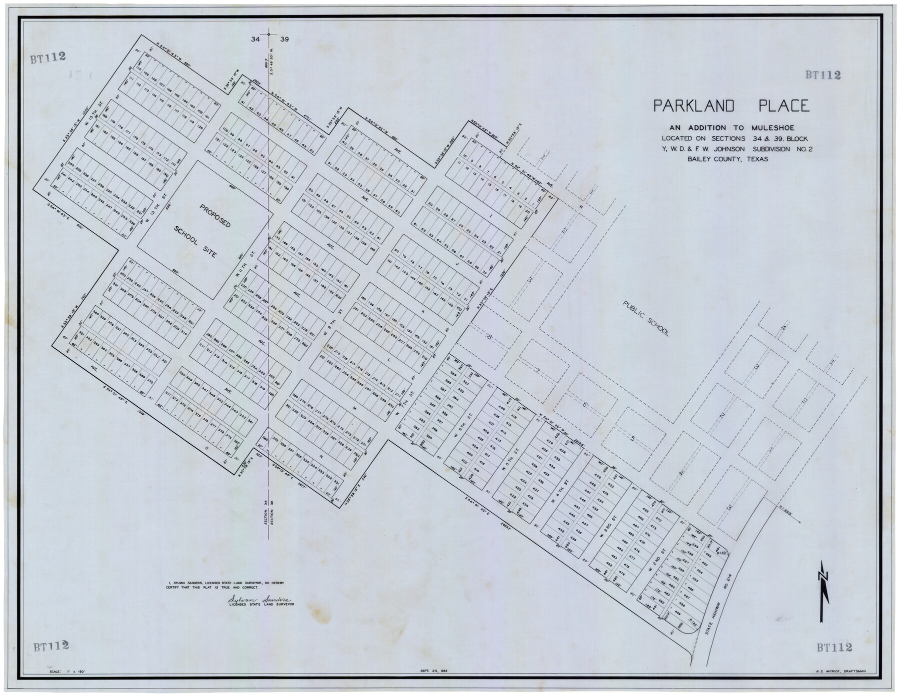
Parkland Place, An Addition to Muleshoe
BT112
-
Map/Doc
92531
-
Collection
Twichell Survey Records
-
Object Dates
9/23/1955 (Creation Date)
-
People and Organizations
Sylvan Sanders (Surveyor/Engineer)
H.S. Myrick (Draftsman)
-
Counties
Bailey
-
Height x Width
39.2 x 30.3 inches
99.6 x 77.0 cm
Part of: Twichell Survey Records
University of Texas System University Lands

Print $20.00
- Digital $50.00
University of Texas System University Lands
1933
Size 23.0 x 17.7 inches
Map/Doc 93248
Hockley County Sketch Mineral Application Number 39180

Print $20.00
- Digital $50.00
Hockley County Sketch Mineral Application Number 39180
1947
Size 16.1 x 20.1 inches
Map/Doc 92246
[Sketch of Surveys south of League 153]
![90438, [Sketch of Surveys south of League 153], Twichell Survey Records](https://historictexasmaps.com/wmedia_w700/maps/90438-1.tif.jpg)
Print $2.00
- Digital $50.00
[Sketch of Surveys south of League 153]
Size 9.1 x 5.9 inches
Map/Doc 90438
[Sketch showing a stretch of T. & P. RR. Line between PSL Blocks B-15 and B-16]
![90902, [Sketch showing a stretch of T. & P. RR. Line between PSL Blocks B-15 and B-16], Twichell Survey Records](https://historictexasmaps.com/wmedia_w700/maps/90902-1.tif.jpg)
Print $20.00
- Digital $50.00
[Sketch showing a stretch of T. & P. RR. Line between PSL Blocks B-15 and B-16]
Size 37.9 x 25.5 inches
Map/Doc 90902
Map of Tascosa, Oldham County, Texas

Print $40.00
- Digital $50.00
Map of Tascosa, Oldham County, Texas
Size 34.8 x 66.8 inches
Map/Doc 89711
[Pencil sketch and calculations regarding section 34, Block 194]
![91663, [Pencil sketch and calculations regarding section 34, Block 194], Twichell Survey Records](https://historictexasmaps.com/wmedia_w700/maps/91663-1.tif.jpg)
Print $20.00
- Digital $50.00
[Pencil sketch and calculations regarding section 34, Block 194]
Size 23.0 x 12.1 inches
Map/Doc 91663
[H. & G. N. Block 1]
![90943, [H. & G. N. Block 1], Twichell Survey Records](https://historictexasmaps.com/wmedia_w700/maps/90943-1.tif.jpg)
Print $20.00
- Digital $50.00
[H. & G. N. Block 1]
1873
Size 14.3 x 17.6 inches
Map/Doc 90943
Magnetic Declination in the United States - Epoch 1980

Print $20.00
- Digital $50.00
Magnetic Declination in the United States - Epoch 1980
1980
Size 41.4 x 33.3 inches
Map/Doc 92368
T. C. Ivey Ranch Block D

Print $20.00
- Digital $50.00
T. C. Ivey Ranch Block D
Size 17.5 x 14.8 inches
Map/Doc 92846
[Surveys to the North and West of the Francis Blundell survey containing townsite]
![90884, [Surveys to the North and West of the Francis Blundell survey containing townsite], Twichell Survey Records](https://historictexasmaps.com/wmedia_w700/maps/90884-1.tif.jpg)
Print $20.00
- Digital $50.00
[Surveys to the North and West of the Francis Blundell survey containing townsite]
Size 26.3 x 19.8 inches
Map/Doc 90884
[Vicinity of Wilson Strickland Survey]
![91380, [Vicinity of Wilson Strickland Survey], Twichell Survey Records](https://historictexasmaps.com/wmedia_w700/maps/91380-1.tif.jpg)
Print $20.00
- Digital $50.00
[Vicinity of Wilson Strickland Survey]
Size 37.1 x 25.5 inches
Map/Doc 91380
[Leagues 258, 259, 278, 287, 288, and Vicinity]
![91459, [Leagues 258, 259, 278, 287, 288, and Vicinity], Twichell Survey Records](https://historictexasmaps.com/wmedia_w700/maps/91459-1.tif.jpg)
Print $20.00
- Digital $50.00
[Leagues 258, 259, 278, 287, 288, and Vicinity]
Size 20.0 x 34.9 inches
Map/Doc 91459
You may also like
Parmer County

Print $20.00
- Digital $50.00
Parmer County
1926
Size 46.2 x 36.5 inches
Map/Doc 66973
Bowie County Working Sketch 5

Print $20.00
- Digital $50.00
Bowie County Working Sketch 5
1927
Size 22.8 x 26.6 inches
Map/Doc 67409
Marion County Working Sketch 41

Print $40.00
- Digital $50.00
Marion County Working Sketch 41
1996
Size 34.0 x 48.5 inches
Map/Doc 70817
[Gulf Coast of Texas]
![72703, [Gulf Coast of Texas], General Map Collection](https://historictexasmaps.com/wmedia_w700/maps/72703.tif.jpg)
Print $20.00
- Digital $50.00
[Gulf Coast of Texas]
1881
Size 28.9 x 18.2 inches
Map/Doc 72703
Collingsworth County Working Sketch 2

Print $20.00
- Digital $50.00
Collingsworth County Working Sketch 2
1957
Size 10.2 x 32.6 inches
Map/Doc 63762
Flight Mission No. BRA-6M, Frame 75, Jefferson County

Print $20.00
- Digital $50.00
Flight Mission No. BRA-6M, Frame 75, Jefferson County
1953
Size 18.8 x 22.5 inches
Map/Doc 85419
Hardin County Sketch File 39 and 40

Print $36.00
- Digital $50.00
Hardin County Sketch File 39 and 40
Size 8.4 x 13.2 inches
Map/Doc 25180
Ochiltree County Rolled Sketch 1

Print $20.00
- Digital $50.00
Ochiltree County Rolled Sketch 1
1942
Size 29.3 x 38.8 inches
Map/Doc 9655
Brewster County Rolled Sketch 114

Print $20.00
- Digital $50.00
Brewster County Rolled Sketch 114
1964
Size 11.7 x 18.4 inches
Map/Doc 5265
Fayette County Working Sketch 7

Print $20.00
- Digital $50.00
Fayette County Working Sketch 7
1981
Size 24.1 x 15.6 inches
Map/Doc 69171
Gray County Working Sketch 3

Print $20.00
- Digital $50.00
Gray County Working Sketch 3
1958
Size 36.4 x 31.8 inches
Map/Doc 63234
Crockett County Sketch File 75a

Print $6.00
- Digital $50.00
Crockett County Sketch File 75a
Size 14.2 x 8.8 inches
Map/Doc 19873