![90987, [School Leagues in Bailey and Lamb County], Twichell Survey Records](https://historictexasmaps.com/wmedia_w1800h1800/maps/90987-2.tif.jpg)
[School Leagues in Bailey and Lamb County]
140-15
-
Map/Doc
90987
-
Collection
Twichell Survey Records
-
Counties
Lamb Bailey
-
Height x Width
30.5 x 25.2 inches
77.5 x 64.0 cm
Part of: Twichell Survey Records
[Sketch of Part of B. S. & F. Block 9]
![93088, [Sketch of Part of B. S. & F. Block 9], Twichell Survey Records](https://historictexasmaps.com/wmedia_w700/maps/93088-1.tif.jpg)
Print $2.00
- Digital $50.00
[Sketch of Part of B. S. & F. Block 9]
Size 8.0 x 7.9 inches
Map/Doc 93088
[South part of Bailey County showing School Leagues]
![92991, [South part of Bailey County showing School Leagues], Twichell Survey Records](https://historictexasmaps.com/wmedia_w700/maps/92991-1.tif.jpg)
Print $2.00
- Digital $50.00
[South part of Bailey County showing School Leagues]
1914
Size 5.9 x 7.6 inches
Map/Doc 92991
Lands of the Eastern Mediterranean

Lands of the Eastern Mediterranean
1959
Size 25.5 x 19.5 inches
Map/Doc 92383
[West line of B. & B. Block 1]
![90584, [West line of B. & B. Block 1], Twichell Survey Records](https://historictexasmaps.com/wmedia_w700/maps/90584-1.tif.jpg)
Print $20.00
- Digital $50.00
[West line of B. & B. Block 1]
Size 12.7 x 15.2 inches
Map/Doc 90584
[H. & T. C. Block 47 and part of G. & M. Block 3]
![91817, [H. & T. C. Block 47 and part of G. & M. Block 3], Twichell Survey Records](https://historictexasmaps.com/wmedia_w700/maps/91817-1.tif.jpg)
Print $20.00
- Digital $50.00
[H. & T. C. Block 47 and part of G. & M. Block 3]
Size 29.4 x 27.9 inches
Map/Doc 91817
[Sections 58-64, I. & G. N. Block 1]
![91546, [Sections 58-64, I. & G. N. Block 1], Twichell Survey Records](https://historictexasmaps.com/wmedia_w700/maps/91546-1.tif.jpg)
Print $2.00
- Digital $50.00
[Sections 58-64, I. & G. N. Block 1]
Size 8.6 x 11.1 inches
Map/Doc 91546
[Nathaniel H. Cochran Survey and Vicinity]
![91399, [Nathaniel H. Cochran Survey and Vicinity], Twichell Survey Records](https://historictexasmaps.com/wmedia_w700/maps/91399-1.tif.jpg)
Print $20.00
- Digital $50.00
[Nathaniel H. Cochran Survey and Vicinity]
1922
Size 22.4 x 22.0 inches
Map/Doc 91399
Arnold Durham Irrigated Farm West Half Section 60, Block 20

Print $20.00
- Digital $50.00
Arnold Durham Irrigated Farm West Half Section 60, Block 20
1945
Size 16.5 x 31.4 inches
Map/Doc 92316
[Worksheets related to the Wilson Strickland survey and vicinity]
![91282, [Worksheets related to the Wilson Strickland survey and vicinity], Twichell Survey Records](https://historictexasmaps.com/wmedia_w700/maps/91282-1.tif.jpg)
Print $20.00
- Digital $50.00
[Worksheets related to the Wilson Strickland survey and vicinity]
Size 7.9 x 24.3 inches
Map/Doc 91282
[Sketch showing various County School Land Leagues]
![89736, [Sketch showing various County School Land Leagues], Twichell Survey Records](https://historictexasmaps.com/wmedia_w700/maps/89736-1.tif.jpg)
Print $40.00
- Digital $50.00
[Sketch showing various County School Land Leagues]
Size 60.6 x 38.5 inches
Map/Doc 89736
Tascotal Mesa Quadrangle

Print $20.00
- Digital $50.00
Tascotal Mesa Quadrangle
1917
Size 17.0 x 20.7 inches
Map/Doc 90134

You may also like
Mexico, Mittel-America, Texas

Print $20.00
- Digital $50.00
Mexico, Mittel-America, Texas
1850
Size 14.4 x 17.7 inches
Map/Doc 93710
Bee County Working Sketch 33

Print $20.00
- Digital $50.00
Bee County Working Sketch 33
1980
Size 32.0 x 28.2 inches
Map/Doc 67284
Hicks, Station Map-Tracks & Structures Lands, San Antonio & Aransas Pass Railway Co.

Print $4.00
- Digital $50.00
Hicks, Station Map-Tracks & Structures Lands, San Antonio & Aransas Pass Railway Co.
1919
Size 11.7 x 18.6 inches
Map/Doc 62568
Map of Burleson County

Print $20.00
- Digital $50.00
Map of Burleson County
1867
Size 19.1 x 30.0 inches
Map/Doc 4511
Kimble County Working Sketch 79

Print $20.00
- Digital $50.00
Kimble County Working Sketch 79
1971
Size 34.7 x 31.9 inches
Map/Doc 70147
Ward County Working Sketch 10

Print $20.00
- Digital $50.00
Ward County Working Sketch 10
1946
Size 29.6 x 15.6 inches
Map/Doc 72316
Val Verde County Working Sketch 12

Print $20.00
- Digital $50.00
Val Verde County Working Sketch 12
1920
Size 29.0 x 24.3 inches
Map/Doc 72147
Gulf of Mexico

Print $20.00
- Digital $50.00
Gulf of Mexico
1905
Size 18.3 x 26.8 inches
Map/Doc 72652
Tyler County Working Sketch 26
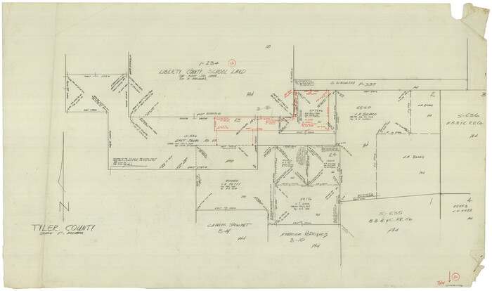
Print $20.00
- Digital $50.00
Tyler County Working Sketch 26
Size 27.7 x 46.3 inches
Map/Doc 69496
Texas, Matagorda Bay, Port O'Connor to Gallinipper Point

Print $40.00
- Digital $50.00
Texas, Matagorda Bay, Port O'Connor to Gallinipper Point
1933
Size 31.1 x 48.6 inches
Map/Doc 69985
Sketch showing progress of topographical work Laguna Madre and vicinity from Rainey Is. to Baffins Bay, Coast of Texas Sect. IX [and accompanying letter]
![72961, Sketch showing progress of topographical work Laguna Madre and vicinity from Rainey Is. to Baffins Bay, Coast of Texas Sect. IX [and accompanying letter], General Map Collection](https://historictexasmaps.com/wmedia_w700/maps/72961.tif.jpg)
Print $2.00
- Digital $50.00
Sketch showing progress of topographical work Laguna Madre and vicinity from Rainey Is. to Baffins Bay, Coast of Texas Sect. IX [and accompanying letter]
Size 11.1 x 8.7 inches
Map/Doc 72961
Edwards County Working Sketch 4

Print $20.00
- Digital $50.00
Edwards County Working Sketch 4
Size 28.7 x 28.3 inches
Map/Doc 68880