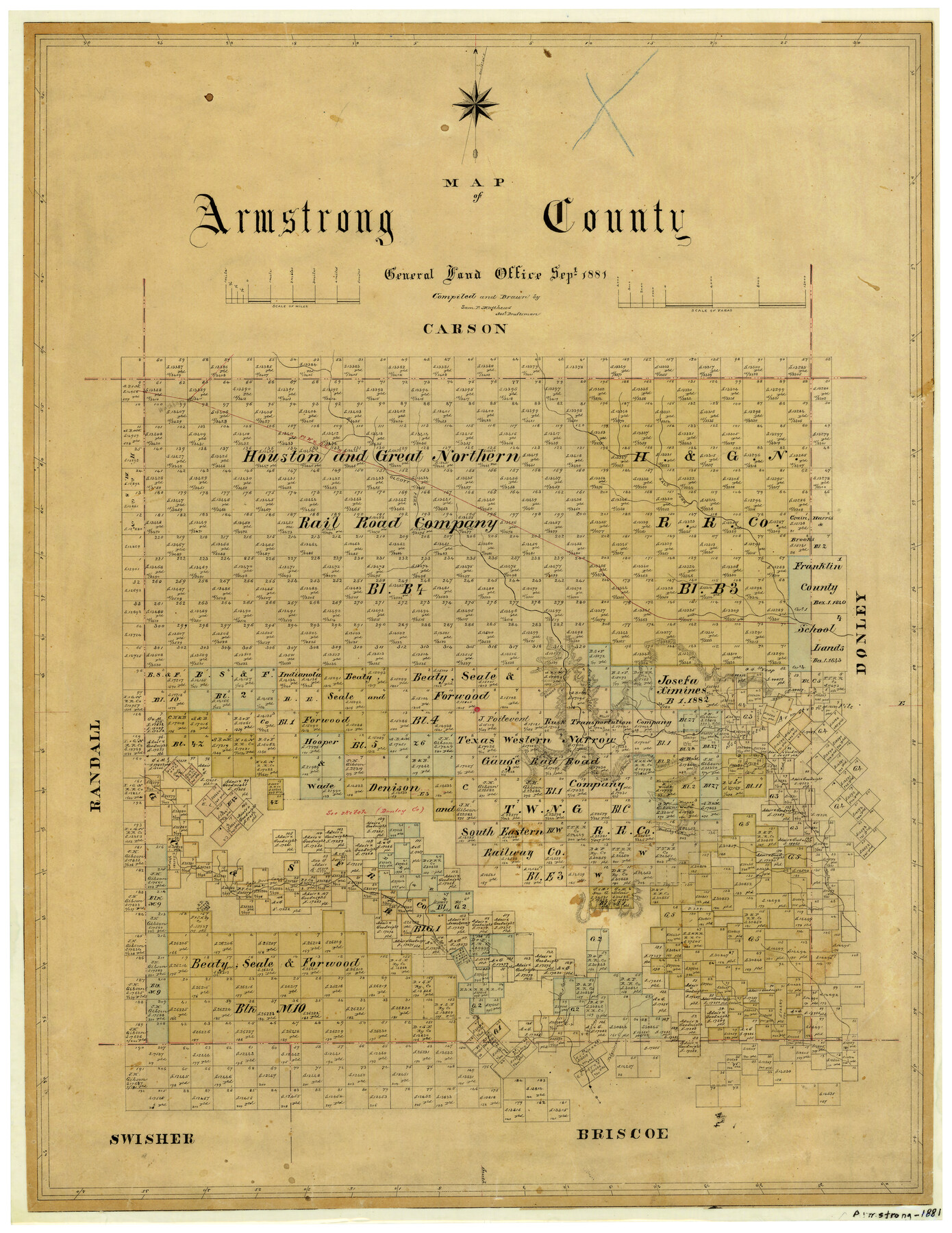
Map of Armstrong County
-
Map/Doc
3243
-
Collection
General Map Collection
-
Object Dates
9/1881 (Creation Date)
-
People and Organizations
Texas General Land Office (Publisher)
Sam. P. Matthews (Draftsman)
Sam. P. Matthews (Compiler)
-
Counties
Armstrong
-
Subjects
County
-
Height x Width
25.8 x 19.9 inches
65.5 x 50.6 cm
-
Features
Turkey Creek
Prairie Dog Fork of Red River
Palo Duro Cañon
Dutchy Canon
Cedar Canon
Deer Creek
Pilgrims Creek
Campbells Creek
Gypsum Creek
Washburn
West Fork of Gypsum Creek
Dugout Creek
Mulberry Creek
Red Creek
FW&DC
Olcott Fork
Salt Fork
Part of: General Map Collection
Township 12 South Range 13 West, South Western District, Louisiana

Print $20.00
- Digital $50.00
Township 12 South Range 13 West, South Western District, Louisiana
1838
Size 19.5 x 24.7 inches
Map/Doc 65855
Hardeman County Sketch File 2

Print $6.00
- Digital $50.00
Hardeman County Sketch File 2
1879
Size 9.0 x 7.7 inches
Map/Doc 24984
Jim Hogg County Rolled Sketch 13

Print $65.00
- Digital $50.00
Jim Hogg County Rolled Sketch 13
1913
Size 21.9 x 28.1 inches
Map/Doc 6444
Flight Mission No. CRC-3R, Frame 96, Chambers County

Print $20.00
- Digital $50.00
Flight Mission No. CRC-3R, Frame 96, Chambers County
1956
Size 18.7 x 22.4 inches
Map/Doc 84834
Harris County Sketch File 35

Print $4.00
- Digital $50.00
Harris County Sketch File 35
1840
Size 14.1 x 9.0 inches
Map/Doc 25438
Palo Pinto County Sketch File 26

Print $8.00
- Digital $50.00
Palo Pinto County Sketch File 26
1993
Size 14.0 x 8.6 inches
Map/Doc 33441
Galveston County NRC Article 33.136 Sketch 83

Print $52.00
- Digital $50.00
Galveston County NRC Article 33.136 Sketch 83
2016
Size 22.5 x 34.0 inches
Map/Doc 94968
Pecos County Rolled Sketch 189

Print $20.00
- Digital $50.00
Pecos County Rolled Sketch 189
1998
Size 22.2 x 33.7 inches
Map/Doc 7307
Val Verde County Working Sketch 57

Print $20.00
- Digital $50.00
Val Verde County Working Sketch 57
1958
Size 29.2 x 31.0 inches
Map/Doc 72192
Frio County Rolled Sketch 12

Print $20.00
- Digital $50.00
Frio County Rolled Sketch 12
1948
Size 36.5 x 45.5 inches
Map/Doc 8904
Cass County Working Sketch 51

Print $20.00
- Digital $50.00
Cass County Working Sketch 51
Size 13.1 x 36.5 inches
Map/Doc 67954

You may also like
Flight Mission No. BRE-2P, Frame 20, Nueces County

Print $20.00
- Digital $50.00
Flight Mission No. BRE-2P, Frame 20, Nueces County
1956
Size 17.1 x 19.8 inches
Map/Doc 86729
Montgomery County Rolled Sketch 19A

Print $40.00
- Digital $50.00
Montgomery County Rolled Sketch 19A
1933
Size 53.4 x 35.4 inches
Map/Doc 9530
Gregg County Working Sketch 8

Print $20.00
- Digital $50.00
Gregg County Working Sketch 8
1936
Size 26.0 x 23.3 inches
Map/Doc 63274
Flight Mission No. DIX-8P, Frame 83, Aransas County

Print $20.00
- Digital $50.00
Flight Mission No. DIX-8P, Frame 83, Aransas County
1956
Size 18.6 x 22.3 inches
Map/Doc 83908
[Movements & Objectives of the 143rd & 144th Infantry on October 9-11, 1918, Appendix E, Nos.2 and 3] - Verso
![94132, [Movements & Objectives of the 143rd & 144th Infantry on October 9-11, 1918, Appendix E, Nos.2 and 3] - Verso, Non-GLO Digital Images](https://historictexasmaps.com/wmedia_w700/maps/94132-1.tif.jpg)
Print $20.00
[Movements & Objectives of the 143rd & 144th Infantry on October 9-11, 1918, Appendix E, Nos.2 and 3] - Verso
1918
Size 41.9 x 20.2 inches
Map/Doc 94132
Val Verde County Sketch File Z13

Print $4.00
- Digital $50.00
Val Verde County Sketch File Z13
1898
Size 11.5 x 8.6 inches
Map/Doc 39142
[State Line from Southeast New Mexico to Yoakum County]
![92013, [State Line from Southeast New Mexico to Yoakum County], Twichell Survey Records](https://historictexasmaps.com/wmedia_w700/maps/92013-1.tif.jpg)
Print $20.00
- Digital $50.00
[State Line from Southeast New Mexico to Yoakum County]
Size 32.3 x 11.7 inches
Map/Doc 92013
Webb County Sketch File 9c

Print $20.00
- Digital $50.00
Webb County Sketch File 9c
1930
Size 18.7 x 22.1 inches
Map/Doc 12621
Val Verde County Rolled Sketch 56

Print $20.00
- Digital $50.00
Val Verde County Rolled Sketch 56
1941
Size 39.3 x 22.8 inches
Map/Doc 8125
Foard County Rolled Sketch 15A

Print $20.00
- Digital $50.00
Foard County Rolled Sketch 15A
1889
Size 37.5 x 36.1 inches
Map/Doc 8339
Kinney County Sketch File 15

Print $20.00
- Digital $50.00
Kinney County Sketch File 15
1887
Size 13.0 x 19.0 inches
Map/Doc 11940
Garza County Working Sketch 3

Print $20.00
- Digital $50.00
Garza County Working Sketch 3
1919
Size 13.8 x 14.0 inches
Map/Doc 63150