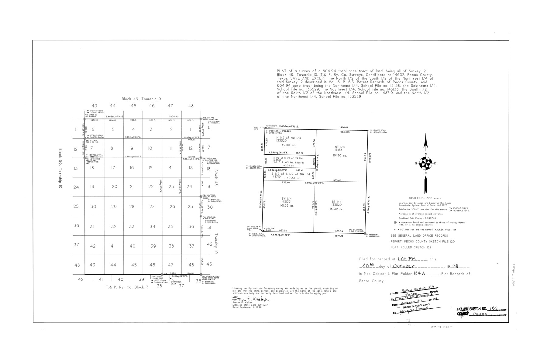
Pecos County Rolled Sketch 189
Plat of a survey of a 604.94 total acre tract of land being all of survey 12, Block 49, Township 10, T. & P. Ry. Co. surveys, certificate no. 4632, Pecos County, Texas save and except the north 1/2 of the south 1/2 of the northwest 1/4 of said survey 12
-
Map/Doc
7307
-
Collection
General Map Collection
-
Object Dates
1998/9/7 (Creation Date)
1998/10/20 (File Date)
-
People and Organizations
Steven F. Walker (Surveyor/Engineer)
-
Counties
Pecos
-
Subjects
Surveying Rolled Sketch
-
Height x Width
22.2 x 33.7 inches
56.4 x 85.6 cm
-
Medium
mylar, print
-
Scale
1" = 300 varas
-
Comments
See Pecos County Sketch File 120 (34114) for report.
Related maps
Pecos County Sketch File 120

Print $4.00
- Digital $50.00
Pecos County Sketch File 120
Size 14.3 x 8.7 inches
Map/Doc 34114
Part of: General Map Collection
Flight Mission No. CON-4R, Frame 88, Stonewall County

Print $20.00
- Digital $50.00
Flight Mission No. CON-4R, Frame 88, Stonewall County
1957
Size 18.2 x 22.0 inches
Map/Doc 86992
United States - Gulf Coast - From Latitude 26° 33' to the Rio Grande Texas

Print $20.00
- Digital $50.00
United States - Gulf Coast - From Latitude 26° 33' to the Rio Grande Texas
1918
Size 27.6 x 18.1 inches
Map/Doc 72849
T. & N. O. R.R. Jefferson Co. North

Print $20.00
- Digital $50.00
T. & N. O. R.R. Jefferson Co. North
1917
Size 13.5 x 33.2 inches
Map/Doc 64057
Taylor County Working Sketch 11

Print $20.00
- Digital $50.00
Taylor County Working Sketch 11
1956
Size 23.0 x 24.4 inches
Map/Doc 69621
Flight Mission No. CRC-4R, Frame 66, Chambers County

Print $20.00
- Digital $50.00
Flight Mission No. CRC-4R, Frame 66, Chambers County
1956
Size 18.6 x 22.5 inches
Map/Doc 84870
Williamson County Working Sketch 10

Print $20.00
- Digital $50.00
Williamson County Working Sketch 10
1961
Size 31.1 x 20.0 inches
Map/Doc 72570
Jim Wells Co.

Print $20.00
- Digital $50.00
Jim Wells Co.
1966
Size 42.7 x 31.0 inches
Map/Doc 73198
Harris County Working Sketch 41

Print $20.00
- Digital $50.00
Harris County Working Sketch 41
1940
Size 37.8 x 29.9 inches
Map/Doc 65933
Red River County Working Sketch 70

Print $20.00
- Digital $50.00
Red River County Working Sketch 70
1977
Size 22.6 x 24.0 inches
Map/Doc 72053
Terrell County Working Sketch 35

Print $20.00
- Digital $50.00
Terrell County Working Sketch 35
1948
Size 38.4 x 42.2 inches
Map/Doc 62127
Travis County Sketch File 22

Print $6.00
- Digital $50.00
Travis County Sketch File 22
1875
Size 8.5 x 8.5 inches
Map/Doc 38327
Polk County Working Sketch 37

Print $20.00
- Digital $50.00
Polk County Working Sketch 37
1974
Size 31.3 x 38.2 inches
Map/Doc 71654
You may also like
Jones County Sketch File 15

Print $40.00
- Digital $50.00
Jones County Sketch File 15
1892
Size 13.7 x 16.3 inches
Map/Doc 28503
Reagan County Sketch File 2B

Print $20.00
- Digital $50.00
Reagan County Sketch File 2B
Size 20.4 x 22.2 inches
Map/Doc 12212
Flight Mission No. BRA-6M, Frame 95, Jefferson County

Print $20.00
- Digital $50.00
Flight Mission No. BRA-6M, Frame 95, Jefferson County
1953
Size 18.5 x 22.2 inches
Map/Doc 85438
[Surveys in Power and Hewetson's Colony]
![2, [Surveys in Power and Hewetson's Colony], General Map Collection](https://historictexasmaps.com/wmedia_w700/maps/2.tif.jpg)
Print $20.00
- Digital $50.00
[Surveys in Power and Hewetson's Colony]
1830
Size 21.3 x 22.5 inches
Map/Doc 2
Maps of Gulf Intracoastal Waterway, Texas - Sabine River to the Rio Grande and connecting waterways including ship channels

Print $20.00
- Digital $50.00
Maps of Gulf Intracoastal Waterway, Texas - Sabine River to the Rio Grande and connecting waterways including ship channels
1966
Size 14.4 x 22.2 inches
Map/Doc 61943
Bowie County Working Sketch 4

Print $20.00
- Digital $50.00
Bowie County Working Sketch 4
1915
Size 19.5 x 14.3 inches
Map/Doc 67408
Presidio County Rolled Sketch 3B

Print $20.00
- Digital $50.00
Presidio County Rolled Sketch 3B
Size 26.2 x 24.1 inches
Map/Doc 7328
[Capitol Leagues 217-228, 238, and vicinity]
![90672, [Capitol Leagues 217-228, 238, and vicinity], Twichell Survey Records](https://historictexasmaps.com/wmedia_w700/maps/90672-1.tif.jpg)
Print $20.00
- Digital $50.00
[Capitol Leagues 217-228, 238, and vicinity]
Size 23.0 x 9.9 inches
Map/Doc 90672
Garza County Sketch File 4a

Print $4.00
- Digital $50.00
Garza County Sketch File 4a
1883
Size 14.2 x 8.8 inches
Map/Doc 24048
[Northeast Portion of Kaufman County]
![91028, [Northeast Portion of Kaufman County], Twichell Survey Records](https://historictexasmaps.com/wmedia_w700/maps/91028-1.tif.jpg)
Print $20.00
- Digital $50.00
[Northeast Portion of Kaufman County]
Size 40.1 x 37.0 inches
Map/Doc 91028
Sherman County Rolled Sketch 12

Print $40.00
- Digital $50.00
Sherman County Rolled Sketch 12
1951
Size 11.1 x 63.8 inches
Map/Doc 9929
Jones County Rolled Sketch 2

Print $40.00
- Digital $50.00
Jones County Rolled Sketch 2
2009
Size 48.0 x 34.0 inches
Map/Doc 93320