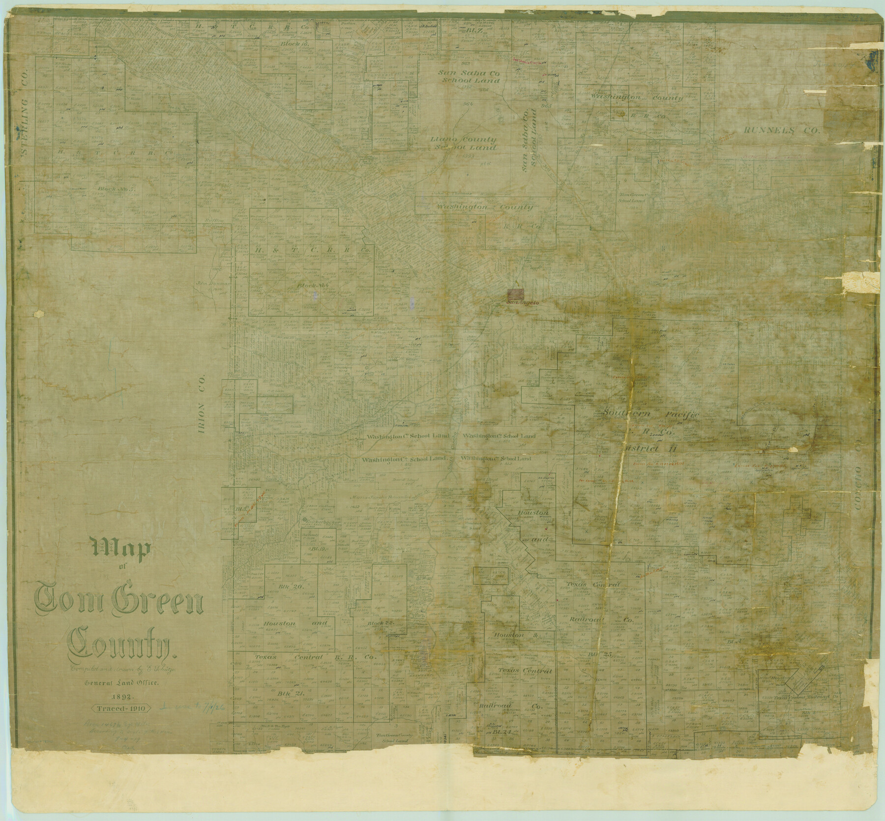
Map of Tom Green County
-
Map/Doc
78390
-
Collection
General Map Collection
-
Object Dates
1892 (Creation Date)
-
People and Organizations
Texas General Land Office (Publisher)
Ed. Schutze (Compiler)
Ed. Schutze (Draftsman)
-
Counties
Tom Green
-
Subjects
County
-
Height x Width
42.9 x 46.2 inches
109.0 x 117.3 cm
-
Comments
Traced in 1910.
In use to 1926.
Help Save Texas History - Adopt Me! -
Features
Cottonwood Creek
Kickapoo Springs
Lipan Springs
Susan Peak
Antelope Creek
Knickerbocker
Dove Creek
Barks Creek
Spring Creek
South Concho River
Dorcas Creek
Lake Creek
Blanche Creek
Mulberry Creek
Catelan Creek
Erica Creek
Middle Concho River
Grigsby Creek
San Angelo
Concho River
Adams Creek
KCM&O
Tom Jeff Creek
Bald Eagle Creek
North Concho River
Grape Creek
Part of: General Map Collection
Flight Mission No. DCL-7C, Frame 95, Kenedy County

Print $20.00
- Digital $50.00
Flight Mission No. DCL-7C, Frame 95, Kenedy County
1943
Size 15.4 x 15.2 inches
Map/Doc 86067
Township 4 South Ranges 12 and 13 West, South Western District, Louisiana

Print $20.00
- Digital $50.00
Township 4 South Ranges 12 and 13 West, South Western District, Louisiana
1879
Size 18.3 x 24.1 inches
Map/Doc 65890
Anderson County

Print $20.00
- Digital $50.00
Anderson County
1871
Size 18.3 x 20.8 inches
Map/Doc 776
Rusk County Sketch File 44

Print $12.00
Rusk County Sketch File 44
1951
Size 11.3 x 8.9 inches
Map/Doc 35585
Smith County Sketch File 3

Print $4.00
- Digital $50.00
Smith County Sketch File 3
1853
Size 10.5 x 8.6 inches
Map/Doc 36750
Runnels County Working Sketch 3

Print $20.00
- Digital $50.00
Runnels County Working Sketch 3
1888
Size 22.1 x 20.3 inches
Map/Doc 63599
Travis County Rolled Sketch 23

Print $20.00
- Digital $50.00
Travis County Rolled Sketch 23
1941
Size 30.5 x 37.7 inches
Map/Doc 8024
Ector County Working Sketch 17

Print $40.00
- Digital $50.00
Ector County Working Sketch 17
1956
Size 59.9 x 24.2 inches
Map/Doc 68860
[Galveston, Harrisburg & San Antonio Railroad from Cuero to Stockdale]
![64187, [Galveston, Harrisburg & San Antonio Railroad from Cuero to Stockdale], General Map Collection](https://historictexasmaps.com/wmedia_w700/maps/64187.tif.jpg)
Print $20.00
- Digital $50.00
[Galveston, Harrisburg & San Antonio Railroad from Cuero to Stockdale]
1906
Size 13.3 x 32.9 inches
Map/Doc 64187
Anderson County Working Sketch 38

Print $20.00
- Digital $50.00
Anderson County Working Sketch 38
1985
Size 43.3 x 45.9 inches
Map/Doc 67038
Flight Mission No. BRA-6M, Frame 80, Jefferson County

Print $20.00
- Digital $50.00
Flight Mission No. BRA-6M, Frame 80, Jefferson County
1953
Size 18.6 x 22.3 inches
Map/Doc 85424
Leon County Working Sketch 58

Print $20.00
- Digital $50.00
Leon County Working Sketch 58
1986
Size 27.7 x 43.3 inches
Map/Doc 70458
You may also like
Harris County Working Sketch 92

Print $40.00
- Digital $50.00
Harris County Working Sketch 92
1974
Size 31.7 x 55.4 inches
Map/Doc 65984
A Map of Louisiana and Mexico

Print $20.00
A Map of Louisiana and Mexico
1820
Size 43.0 x 32.6 inches
Map/Doc 76218
Hardin County Sketch File 21

Print $4.00
- Digital $50.00
Hardin County Sketch File 21
Size 11.2 x 8.8 inches
Map/Doc 25140
Hays County Working Sketch 18

Print $20.00
- Digital $50.00
Hays County Working Sketch 18
1978
Size 33.4 x 32.0 inches
Map/Doc 66092
Flight Mission No. DIX-10P, Frame 68, Aransas County

Print $20.00
- Digital $50.00
Flight Mission No. DIX-10P, Frame 68, Aransas County
1956
Size 18.9 x 22.5 inches
Map/Doc 83929
Montgomery County Rolled Sketch 46

Print $20.00
- Digital $50.00
Montgomery County Rolled Sketch 46
2006
Size 28.2 x 23.0 inches
Map/Doc 87940
Wilbarger County Sketch File 24

Print $20.00
- Digital $50.00
Wilbarger County Sketch File 24
1894
Size 23.3 x 14.9 inches
Map/Doc 12691
Oldham County

Print $20.00
- Digital $50.00
Oldham County
1888
Size 19.8 x 16.5 inches
Map/Doc 93019
Capitol Syndicate Subdivision of Capitol Land Reservation Leagues

Print $20.00
- Digital $50.00
Capitol Syndicate Subdivision of Capitol Land Reservation Leagues
1908
Size 25.6 x 31.5 inches
Map/Doc 92584
Llano County Working Sketch 10

Print $20.00
- Digital $50.00
Llano County Working Sketch 10
1980
Size 21.2 x 15.1 inches
Map/Doc 70628
Wise County Sketch File 20

Print $14.00
- Digital $50.00
Wise County Sketch File 20
1860
Size 12.8 x 7.9 inches
Map/Doc 40557
Briscoe County

Print $20.00
- Digital $50.00
Briscoe County
1879
Size 24.8 x 21.7 inches
Map/Doc 3331