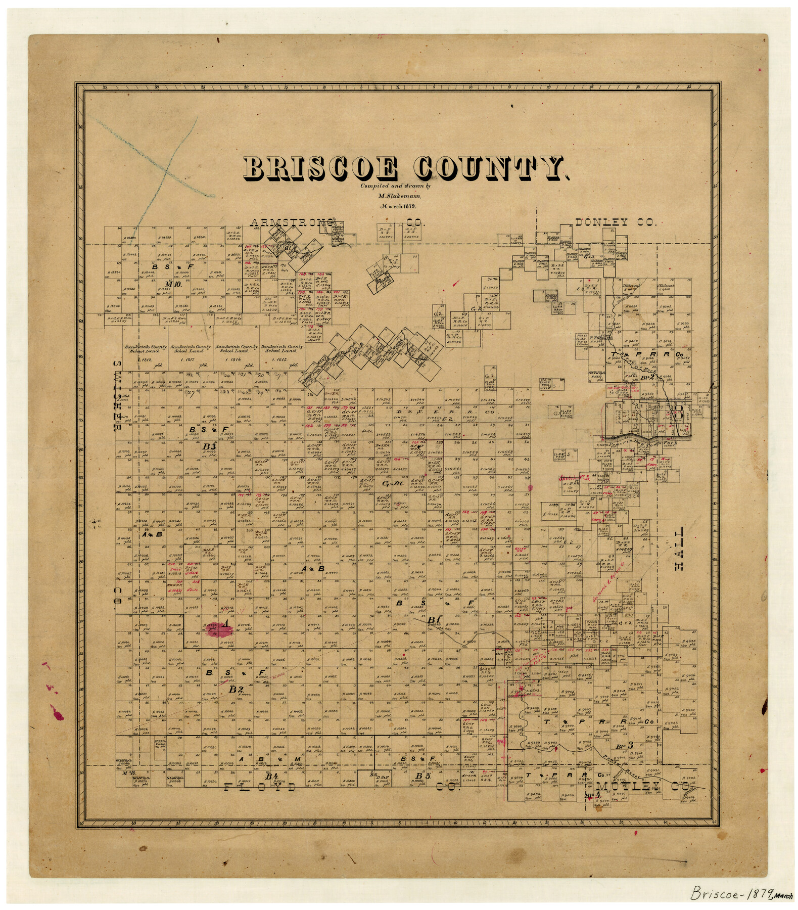
Briscoe County
-
Map/Doc
3331
-
Collection
General Map Collection
-
Object Dates
3/1879 (Creation Date)
-
People and Organizations
Texas General Land Office (Publisher)
Max Stakemann (Draftsman)
Max Stakemann (Compiler)
-
Counties
Briscoe
-
Subjects
County
-
Height x Width
24.8 x 21.7 inches
63.0 x 55.1 cm
-
Features
Turkey Creek
West Fork of Gypsum Creek
Gypsum Creek
Charlie's Creek
Byrne's Fork of Prairie Dog Town Fork [of Red River]
Prairie Dog Town Fork [of Red River]
Pease River
Warren Creek
Robert's Creek
Part of: General Map Collection
Freestone County Sketch File 5

Print $42.00
- Digital $50.00
Freestone County Sketch File 5
1854
Size 4.6 x 5.2 inches
Map/Doc 23047
Rio Grande, Brownsville Sheet No. 1

Print $6.00
- Digital $50.00
Rio Grande, Brownsville Sheet No. 1
1924
Size 28.3 x 35.4 inches
Map/Doc 65130
Aransas County Rolled Sketch 4

Print $20.00
- Digital $50.00
Aransas County Rolled Sketch 4
1952
Size 28.9 x 26.4 inches
Map/Doc 77189
Dickens County Sketch File 2

Print $20.00
- Digital $50.00
Dickens County Sketch File 2
1913
Size 22.0 x 32.3 inches
Map/Doc 11316
Borden County Working Sketch 13

Print $20.00
- Digital $50.00
Borden County Working Sketch 13
1958
Size 24.1 x 35.6 inches
Map/Doc 67473
Flight Mission No. CUG-3P, Frame 93, Kleberg County

Print $20.00
- Digital $50.00
Flight Mission No. CUG-3P, Frame 93, Kleberg County
1956
Size 18.5 x 22.2 inches
Map/Doc 86263
[Gulf, Colorado & Santa Fe]
![64592, [Gulf, Colorado & Santa Fe], General Map Collection](https://historictexasmaps.com/wmedia_w700/maps/64592.tif.jpg)
Print $40.00
- Digital $50.00
[Gulf, Colorado & Santa Fe]
1918
Size 33.2 x 110.5 inches
Map/Doc 64592
Wilbarger County Aerial Photograph Index Sheet 4

Print $20.00
- Digital $50.00
Wilbarger County Aerial Photograph Index Sheet 4
1950
Size 21.7 x 18.8 inches
Map/Doc 83753
Tarrant County Sketch File 12

Print $4.00
- Digital $50.00
Tarrant County Sketch File 12
1859
Size 10.1 x 8.3 inches
Map/Doc 37703
Bailey County

Print $40.00
- Digital $50.00
Bailey County
1956
Size 49.4 x 31.4 inches
Map/Doc 95423
Hopkins County Sketch File 24

Print $4.00
- Digital $50.00
Hopkins County Sketch File 24
1871
Size 12.8 x 8.4 inches
Map/Doc 26734
Presidio County Sketch File 73

Print $11.00
- Digital $50.00
Presidio County Sketch File 73
1944
Size 11.4 x 8.8 inches
Map/Doc 34682
You may also like
Upton County Boundary File 3

Print $80.00
- Digital $50.00
Upton County Boundary File 3
Size 49.1 x 7.8 inches
Map/Doc 59534
Matagorda County Rolled Sketch 26

Print $20.00
- Digital $50.00
Matagorda County Rolled Sketch 26
1950
Size 39.5 x 42.1 inches
Map/Doc 9479
Johnson County

Print $20.00
- Digital $50.00
Johnson County
1857
Size 19.2 x 29.1 inches
Map/Doc 3734
Mills County Sketch File 9

Print $20.00
- Digital $50.00
Mills County Sketch File 9
Size 36.0 x 29.5 inches
Map/Doc 10544
Haskell County Working Sketch 16

Print $20.00
- Digital $50.00
Haskell County Working Sketch 16
1986
Size 37.9 x 47.3 inches
Map/Doc 66074
Hale County Sketch File 5-5a

Print $30.00
- Digital $50.00
Hale County Sketch File 5-5a
1891
Size 17.7 x 38.3 inches
Map/Doc 10467
Tyler County Sketch File 2

Print $4.00
- Digital $50.00
Tyler County Sketch File 2
Size 6.3 x 5.6 inches
Map/Doc 38615

Parker County Sketch File 15A

Print $20.00
- Digital $50.00
Parker County Sketch File 15A
1875
Size 28.5 x 13.6 inches
Map/Doc 12144
Archer County Working Sketch 6

Print $20.00
- Digital $50.00
Archer County Working Sketch 6
1920
Size 16.9 x 27.7 inches
Map/Doc 67146
Flight Mission No. DAG-21K, Frame 92, Matagorda County

Print $20.00
- Digital $50.00
Flight Mission No. DAG-21K, Frame 92, Matagorda County
1952
Size 18.5 x 22.4 inches
Map/Doc 86421
Northwest Part Pecos County

Print $20.00
- Digital $50.00
Northwest Part Pecos County
1975
Size 42.2 x 42.2 inches
Map/Doc 77395