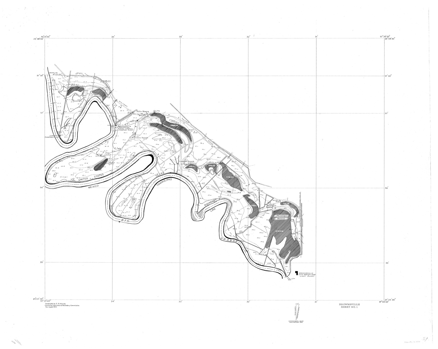
Rio Grande, Brownsville Sheet No. 1
-
Map/Doc
65130
-
Collection
General Map Collection
-
Object Dates
1924 (Creation Date)
-
People and Organizations
Texas State Reclamation Department (Publisher)
E.R. Manley (Surveyor/Engineer)
-
Counties
Cameron
-
Subjects
River Surveys Topographic
-
Height x Width
28.3 x 35.4 inches
71.9 x 89.9 cm
Part of: General Map Collection
Flight Mission No. DCL-6C, Frame 47, Kenedy County

Print $20.00
- Digital $50.00
Flight Mission No. DCL-6C, Frame 47, Kenedy County
1943
Size 18.7 x 22.4 inches
Map/Doc 85889
Presidio County Rolled Sketch 82

Print $20.00
- Digital $50.00
Presidio County Rolled Sketch 82
1943
Size 35.5 x 26.1 inches
Map/Doc 7369
Fisher County Sketch File 13

Print $20.00
- Digital $50.00
Fisher County Sketch File 13
Size 18.3 x 17.7 inches
Map/Doc 11480
Zapata County Rolled Sketch 28

Print $20.00
- Digital $50.00
Zapata County Rolled Sketch 28
Size 35.5 x 35.3 inches
Map/Doc 10174
Intracoastal Waterway in Texas - Corpus Christi to Point Isabel including Arroyo Colorado to Mo. Pac. R.R. Bridge Near Harlingen

Print $20.00
- Digital $50.00
Intracoastal Waterway in Texas - Corpus Christi to Point Isabel including Arroyo Colorado to Mo. Pac. R.R. Bridge Near Harlingen
1933
Size 27.7 x 40.9 inches
Map/Doc 61859
Hardeman County Sketch File 32

Print $4.00
- Digital $50.00
Hardeman County Sketch File 32
Size 11.1 x 8.9 inches
Map/Doc 25068
Orange County Aerial Photograph Index Sheet 3

Print $20.00
- Digital $50.00
Orange County Aerial Photograph Index Sheet 3
1953
Size 22.8 x 17.8 inches
Map/Doc 83741
Terry County Boundary File 3

Print $78.00
- Digital $50.00
Terry County Boundary File 3
Size 7.4 x 8.8 inches
Map/Doc 59216
San Patricio County Sketch File 38

Print $112.00
- Digital $50.00
San Patricio County Sketch File 38
Size 7.9 x 7.3 inches
Map/Doc 36176
El Paso County Rolled Sketch 37

Print $40.00
- Digital $50.00
El Paso County Rolled Sketch 37
1916
Size 42.8 x 77.0 inches
Map/Doc 76181
Johnson County Working Sketch 8

Print $20.00
- Digital $50.00
Johnson County Working Sketch 8
1952
Size 20.0 x 17.3 inches
Map/Doc 66621
Flight Mission No. DCL-5C, Frame 28, Kenedy County

Print $20.00
- Digital $50.00
Flight Mission No. DCL-5C, Frame 28, Kenedy County
1943
Size 18.5 x 22.3 inches
Map/Doc 85840
You may also like
[Sketch of surveys in the Bexar District along the Pedernales River]
![103, [Sketch of surveys in the Bexar District along the Pedernales River], General Map Collection](https://historictexasmaps.com/wmedia_w700/maps/103-1.tif.jpg)
Print $2.00
- Digital $50.00
[Sketch of surveys in the Bexar District along the Pedernales River]
1847
Size 13.6 x 8.3 inches
Map/Doc 103
Baylor County Sketch File A6

Print $80.00
- Digital $50.00
Baylor County Sketch File A6
1899
Size 22.5 x 31.7 inches
Map/Doc 10912
Jeff Davis County Rolled Sketch 21

Print $20.00
- Digital $50.00
Jeff Davis County Rolled Sketch 21
1946
Size 46.5 x 38.7 inches
Map/Doc 9267
Newton County Working Sketch 45

Print $20.00
- Digital $50.00
Newton County Working Sketch 45
1996
Size 16.4 x 24.0 inches
Map/Doc 71291
Hudspeth County Working Sketch 15

Print $20.00
- Digital $50.00
Hudspeth County Working Sketch 15
1954
Size 36.4 x 16.2 inches
Map/Doc 66297
Pecos County Working Sketch 43

Print $40.00
- Digital $50.00
Pecos County Working Sketch 43
1943
Size 19.5 x 50.7 inches
Map/Doc 71515
Kimble County Working Sketch 84

Print $20.00
- Digital $50.00
Kimble County Working Sketch 84
1972
Size 32.5 x 30.7 inches
Map/Doc 70152
San Saba County Sketch File 4a

Print $4.00
- Digital $50.00
San Saba County Sketch File 4a
1854
Size 9.6 x 8.5 inches
Map/Doc 36410
[Plat of Colorado River Survey, McCulloch County]
![2462, [Plat of Colorado River Survey, McCulloch County], General Map Collection](https://historictexasmaps.com/wmedia_w700/maps/2462-1.tif.jpg)
Print $40.00
- Digital $50.00
[Plat of Colorado River Survey, McCulloch County]
1918
Size 40.3 x 159.2 inches
Map/Doc 2462
Brewster County Working Sketch 61

Print $20.00
- Digital $50.00
Brewster County Working Sketch 61
1955
Size 32.1 x 43.3 inches
Map/Doc 67662
Zavala County

Print $40.00
- Digital $50.00
Zavala County
1977
Size 43.6 x 49.3 inches
Map/Doc 95684
[Unidentified Railroad through Denton and Dallas County]
![64775, [Unidentified Railroad through Denton and Dallas County], General Map Collection](https://historictexasmaps.com/wmedia_w700/maps/64775.tif.jpg)
Print $40.00
- Digital $50.00
[Unidentified Railroad through Denton and Dallas County]
Size 6.8 x 73.3 inches
Map/Doc 64775