Lampasas River, City of Lampasas, Lampasas Sheet/Sulphur & Burleson Creeks

Print $20.00
- Digital $50.00
Lampasas River, City of Lampasas, Lampasas Sheet/Sulphur & Burleson Creeks
1937
Size: 33.4 x 19.3 inches
16956
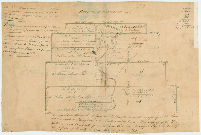
Map of the River Sabine from its mouth on the Gulf of Mexico in the Sea to Logan's Ferry in Latitude 31°58'24" North

Print $40.00
- Digital $50.00
Map of the River Sabine from its mouth on the Gulf of Mexico in the Sea to Logan's Ferry in Latitude 31°58'24" North
1842
Size: 173.2 x 31.0 inches
1744
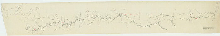
[Titles along the Trinity River]
Print $3.00
- Digital $50.00
[Titles along the Trinity River]
Size: 10.6 x 15.8 inches
175
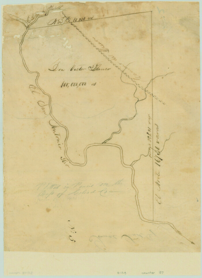
[Victor Blanco's survey along the San Antonio River]
Print $2.00
- Digital $50.00
[Victor Blanco's survey along the San Antonio River]
Size: 11.2 x 8.2 inches
187
Orange County Sabine River Leases 1,2,3,4

Print $20.00
- Digital $50.00
Orange County Sabine River Leases 1,2,3,4
1950
Size: 36.5 x 22.4 inches
1931
Orange County, West Half of Sabine River Showing Leases 5 and 6

Print $20.00
- Digital $50.00
Orange County, West Half of Sabine River Showing Leases 5 and 6
1957
Size: 30.6 x 34.3 inches
1934
[Traverse up the Brazos and Colorado River showing distance from county site to county site]
Print $40.00
- Digital $50.00
[Traverse up the Brazos and Colorado River showing distance from county site to county site]
1871
Size: 16.2 x 98.8 inches
2054
Lake Austin, Travis County, Texas

Print $20.00
- Digital $50.00
Lake Austin, Travis County, Texas
1937
Size: 24.8 x 16.4 inches
2056
Jalisco Banco Number 67, cut from Mexico in 1909

Print $3.00
- Digital $50.00
Jalisco Banco Number 67, cut from Mexico in 1909
1912
Size: 14.2 x 11.2 inches
2064
Rio Grande from San Juan River to the Gulf of Mexico showing Boundary between the United States and Mexico

Print $20.00
- Digital $50.00
Rio Grande from San Juan River to the Gulf of Mexico showing Boundary between the United States and Mexico
1903
Size: 25.6 x 15.8 inches
2065
[Plat of Colorado River Survey, McCulloch County]
Print $40.00
- Digital $50.00
[Plat of Colorado River Survey, McCulloch County]
1918
Size: 40.3 x 159.2 inches
2462
Plat of South 1/2 of Colorado River Channel in McCulloch Co., Texas from Concho County line down river 34 mile 315 varas

Print $40.00
- Digital $50.00
Plat of South 1/2 of Colorado River Channel in McCulloch Co., Texas from Concho County line down river 34 mile 315 varas
1918
Size: 41.5 x 104.6 inches
2463
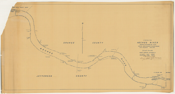
Map of Neches River, Texas from Sabine Lake to Beaumont, Texas

Print $40.00
- Digital $50.00
Map of Neches River, Texas from Sabine Lake to Beaumont, Texas
1910
Size: 32.4 x 104.0 inches
2465
[Neches River Bed, Plat and Calculations]
Print $40.00
- Digital $50.00
[Neches River Bed, Plat and Calculations]
1928
Size: 27.3 x 51.0 inches
2466
General Land Office and State Reclamation Department - An Index Map

Print $20.00
- Digital $50.00
General Land Office and State Reclamation Department - An Index Map
1930
Size: 25.8 x 16.4 inches
3027
Lake Buchanan, Burnet and Llano Counties, Texas

Print $20.00
- Digital $50.00
Lake Buchanan, Burnet and Llano Counties, Texas
1935
Size: 20.7 x 14.4 inches
3136
San Jacinto River and Tributaries, Texas - Survey of 1939

Print $20.00
- Digital $50.00
San Jacinto River and Tributaries, Texas - Survey of 1939
1939
Size: 28.1 x 40.5 inches
3153
A Portion of the State's Submerged Oil Field, Goose Creek - Harris County - Texas

Print $20.00
- Digital $50.00
A Portion of the State's Submerged Oil Field, Goose Creek - Harris County - Texas
1919
Size: 14.2 x 17.3 inches
3165
Military Reconnaissance of the Arkansas Rio Del Norte and Rio Gila

Print $40.00
- Digital $50.00
Military Reconnaissance of the Arkansas Rio Del Norte and Rio Gila
1847
Size: 33.0 x 72.2 inches
552
Highland Lakes of Central Texas

Print $20.00
- Digital $50.00
Highland Lakes of Central Texas
1947
Size: 18.2 x 21.9 inches
60291
Map showing contour of lake to be formed by the Marshall-Ford Dam on the Colorado River in Travis County, Texas and the land surveys crossed by this contour and contiguous to the lake

Print $20.00
- Digital $50.00
Map showing contour of lake to be formed by the Marshall-Ford Dam on the Colorado River in Travis County, Texas and the land surveys crossed by this contour and contiguous to the lake
1937
Size: 22.6 x 18.8 inches
60292
Road Guide of Central Texas, Colorado River, Highland Lakes and Hill Country

Print $20.00
- Digital $50.00
Road Guide of Central Texas, Colorado River, Highland Lakes and Hill Country
1947
Size: 18.0 x 21.7 inches
60293
San Jacinto River and Tributaries, Texas - Survey of 1939

Print $20.00
- Digital $50.00
San Jacinto River and Tributaries, Texas - Survey of 1939
1939
Size: 28.0 x 40.3 inches
60305
San Jacinto River and Tributaries, Texas - Survey of 1939

Print $20.00
- Digital $50.00
San Jacinto River and Tributaries, Texas - Survey of 1939
1939
Size: 27.7 x 40.4 inches
60306
San Jacinto River and Tributaries, Texas - Survey of 1939

Print $20.00
- Digital $50.00
San Jacinto River and Tributaries, Texas - Survey of 1939
1939
Size: 28.0 x 40.3 inches
60307
San Jacinto River and Tributaries, Texas - Survey of 1939

Print $20.00
- Digital $50.00
San Jacinto River and Tributaries, Texas - Survey of 1939
1939
Size: 27.8 x 40.7 inches
60308
San Jacinto River and Tributaries, Texas - Survey of 1939

Print $20.00
- Digital $50.00
San Jacinto River and Tributaries, Texas - Survey of 1939
1939
Size: 27.7 x 40.4 inches
60309
San Jacinto River and Tributaries, Texas - Survey of 1939

Print $20.00
- Digital $50.00
San Jacinto River and Tributaries, Texas - Survey of 1939
1939
Size: 27.7 x 40.5 inches
60310
Lampasas River, City of Lampasas, Lampasas Sheet/Sulphur & Burleson Creeks
Print $20.00
- Digital $50.00
Lampasas River, City of Lampasas, Lampasas Sheet/Sulphur & Burleson Creeks
1937
-
Size
33.4 x 19.3 inches
-
Map/Doc
16956
-
Creation Date
1937
Map of the River Sabine from its mouth on the Gulf of Mexico in the Sea to Logan's Ferry in Latitude 31°58'24" North
Print $40.00
- Digital $50.00
Map of the River Sabine from its mouth on the Gulf of Mexico in the Sea to Logan's Ferry in Latitude 31°58'24" North
1842
-
Size
173.2 x 31.0 inches
-
Map/Doc
1744
-
Creation Date
1842
[Titles along the Trinity River]
Print $3.00
- Digital $50.00
[Titles along the Trinity River]
-
Size
10.6 x 15.8 inches
-
Map/Doc
175
[Victor Blanco's survey along the San Antonio River]
Print $2.00
- Digital $50.00
[Victor Blanco's survey along the San Antonio River]
-
Size
11.2 x 8.2 inches
-
Map/Doc
187
Orange County Sabine River Leases 1,2,3,4
Print $20.00
- Digital $50.00
Orange County Sabine River Leases 1,2,3,4
1950
-
Size
36.5 x 22.4 inches
-
Map/Doc
1931
-
Creation Date
1950
Orange County, West Half of Sabine River Showing Leases 5 and 6
Print $20.00
- Digital $50.00
Orange County, West Half of Sabine River Showing Leases 5 and 6
1957
-
Size
30.6 x 34.3 inches
-
Map/Doc
1934
-
Creation Date
1957
[Traverse up the Brazos and Colorado River showing distance from county site to county site]
Print $40.00
- Digital $50.00
[Traverse up the Brazos and Colorado River showing distance from county site to county site]
1871
-
Size
16.2 x 98.8 inches
-
Map/Doc
2054
-
Creation Date
1871
Lake Austin, Travis County, Texas
Print $20.00
- Digital $50.00
Lake Austin, Travis County, Texas
1937
-
Size
24.8 x 16.4 inches
-
Map/Doc
2056
-
Creation Date
1937
Jalisco Banco Number 67, cut from Mexico in 1909
Print $3.00
- Digital $50.00
Jalisco Banco Number 67, cut from Mexico in 1909
1912
-
Size
14.2 x 11.2 inches
-
Map/Doc
2064
-
Creation Date
1912
Rio Grande from San Juan River to the Gulf of Mexico showing Boundary between the United States and Mexico
Print $20.00
- Digital $50.00
Rio Grande from San Juan River to the Gulf of Mexico showing Boundary between the United States and Mexico
1903
-
Size
25.6 x 15.8 inches
-
Map/Doc
2065
-
Creation Date
1903
[Plat of Colorado River Survey, McCulloch County]
Print $40.00
- Digital $50.00
[Plat of Colorado River Survey, McCulloch County]
1918
-
Size
40.3 x 159.2 inches
-
Map/Doc
2462
-
Creation Date
1918
Plat of South 1/2 of Colorado River Channel in McCulloch Co., Texas from Concho County line down river 34 mile 315 varas
Print $40.00
- Digital $50.00
Plat of South 1/2 of Colorado River Channel in McCulloch Co., Texas from Concho County line down river 34 mile 315 varas
1918
-
Size
41.5 x 104.6 inches
-
Map/Doc
2463
-
Creation Date
1918
Map of Neches River, Texas from Sabine Lake to Beaumont, Texas
Print $40.00
- Digital $50.00
Map of Neches River, Texas from Sabine Lake to Beaumont, Texas
1910
-
Size
32.4 x 104.0 inches
-
Map/Doc
2465
-
Creation Date
1910
[Neches River Bed, Plat and Calculations]
Print $40.00
- Digital $50.00
[Neches River Bed, Plat and Calculations]
1928
-
Size
27.3 x 51.0 inches
-
Map/Doc
2466
-
Creation Date
1928
[Pecos River Bed]
![2467, [Pecos River Bed], General Map Collection](https://historictexasmaps.com/wmedia_w700/maps/2467.tif.jpg)
Print $20.00
- Digital $50.00
[Pecos River Bed]
-
Size
16.6 x 39.8 inches
-
Map/Doc
2467
General Land Office and State Reclamation Department - An Index Map
Print $20.00
- Digital $50.00
General Land Office and State Reclamation Department - An Index Map
1930
-
Size
25.8 x 16.4 inches
-
Map/Doc
3027
-
Creation Date
1930
Lake Travis

Print $20.00
- Digital $50.00
Lake Travis
1937
-
Size
21.5 x 15.8 inches
-
Map/Doc
3082
-
Creation Date
1937
Lake Buchanan, Burnet and Llano Counties, Texas
Print $20.00
- Digital $50.00
Lake Buchanan, Burnet and Llano Counties, Texas
1935
-
Size
20.7 x 14.4 inches
-
Map/Doc
3136
-
Creation Date
1935
San Jacinto River and Tributaries, Texas - Survey of 1939
Print $20.00
- Digital $50.00
San Jacinto River and Tributaries, Texas - Survey of 1939
1939
-
Size
28.1 x 40.5 inches
-
Map/Doc
3153
-
Creation Date
1939
A Portion of the State's Submerged Oil Field, Goose Creek - Harris County - Texas
Print $20.00
- Digital $50.00
A Portion of the State's Submerged Oil Field, Goose Creek - Harris County - Texas
1919
-
Size
14.2 x 17.3 inches
-
Map/Doc
3165
-
Creation Date
1919
Military Reconnaissance of the Arkansas Rio Del Norte and Rio Gila
Print $40.00
- Digital $50.00
Military Reconnaissance of the Arkansas Rio Del Norte and Rio Gila
1847
-
Size
33.0 x 72.2 inches
-
Map/Doc
552
-
Creation Date
1847
Highland Lakes of Central Texas
Print $20.00
- Digital $50.00
Highland Lakes of Central Texas
1947
-
Size
18.2 x 21.9 inches
-
Map/Doc
60291
-
Creation Date
1947
Map showing contour of lake to be formed by the Marshall-Ford Dam on the Colorado River in Travis County, Texas and the land surveys crossed by this contour and contiguous to the lake
Print $20.00
- Digital $50.00
Map showing contour of lake to be formed by the Marshall-Ford Dam on the Colorado River in Travis County, Texas and the land surveys crossed by this contour and contiguous to the lake
1937
-
Size
22.6 x 18.8 inches
-
Map/Doc
60292
-
Creation Date
1937
Road Guide of Central Texas, Colorado River, Highland Lakes and Hill Country
Print $20.00
- Digital $50.00
Road Guide of Central Texas, Colorado River, Highland Lakes and Hill Country
1947
-
Size
18.0 x 21.7 inches
-
Map/Doc
60293
-
Creation Date
1947
San Jacinto River and Tributaries, Texas - Survey of 1939
Print $20.00
- Digital $50.00
San Jacinto River and Tributaries, Texas - Survey of 1939
1939
-
Size
28.0 x 40.3 inches
-
Map/Doc
60305
-
Creation Date
1939
San Jacinto River and Tributaries, Texas - Survey of 1939
Print $20.00
- Digital $50.00
San Jacinto River and Tributaries, Texas - Survey of 1939
1939
-
Size
27.7 x 40.4 inches
-
Map/Doc
60306
-
Creation Date
1939
San Jacinto River and Tributaries, Texas - Survey of 1939
Print $20.00
- Digital $50.00
San Jacinto River and Tributaries, Texas - Survey of 1939
1939
-
Size
28.0 x 40.3 inches
-
Map/Doc
60307
-
Creation Date
1939
San Jacinto River and Tributaries, Texas - Survey of 1939
Print $20.00
- Digital $50.00
San Jacinto River and Tributaries, Texas - Survey of 1939
1939
-
Size
27.8 x 40.7 inches
-
Map/Doc
60308
-
Creation Date
1939
San Jacinto River and Tributaries, Texas - Survey of 1939
Print $20.00
- Digital $50.00
San Jacinto River and Tributaries, Texas - Survey of 1939
1939
-
Size
27.7 x 40.4 inches
-
Map/Doc
60309
-
Creation Date
1939
San Jacinto River and Tributaries, Texas - Survey of 1939
Print $20.00
- Digital $50.00
San Jacinto River and Tributaries, Texas - Survey of 1939
1939
-
Size
27.7 x 40.5 inches
-
Map/Doc
60310
-
Creation Date
1939