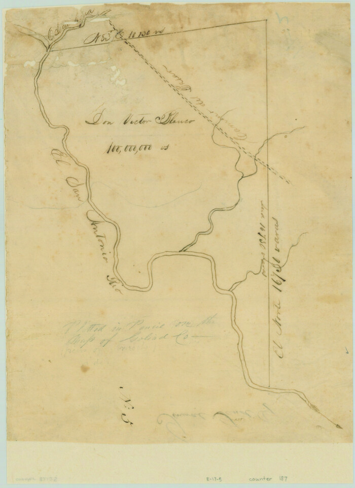
[Victor Blanco's survey along the San Antonio River]
Print $2.00
- Digital $50.00
[Victor Blanco's survey along the San Antonio River]
Size: 11.2 x 8.2 inches
187
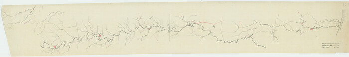
[Traverse up the Brazos and Colorado River showing distance from county site to county site]
Print $40.00
- Digital $50.00
[Traverse up the Brazos and Colorado River showing distance from county site to county site]
1871
Size: 16.2 x 98.8 inches
2054
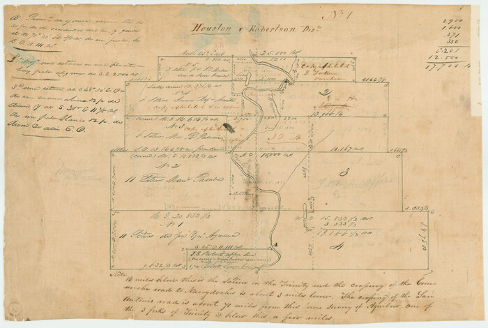
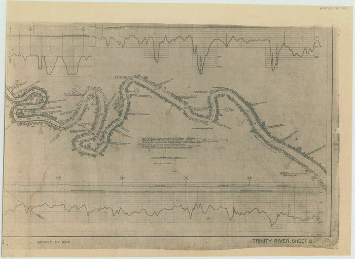
[Titles along the Trinity River]
Print $3.00
- Digital $50.00
[Titles along the Trinity River]
Size: 10.6 x 15.8 inches
175
[Sketch for Mineral Application 13436 - Cut-off Bayou]
Print $20.00
- Digital $50.00
[Sketch for Mineral Application 13436 - Cut-off Bayou]
1928
Size: 21.3 x 44.3 inches
65675
[Sketch for Mineral Application 13436 - Cut-off Bayou]
Print $20.00
- Digital $50.00
[Sketch for Mineral Application 13436 - Cut-off Bayou]
1928
Size: 44.1 x 21.6 inches
65676
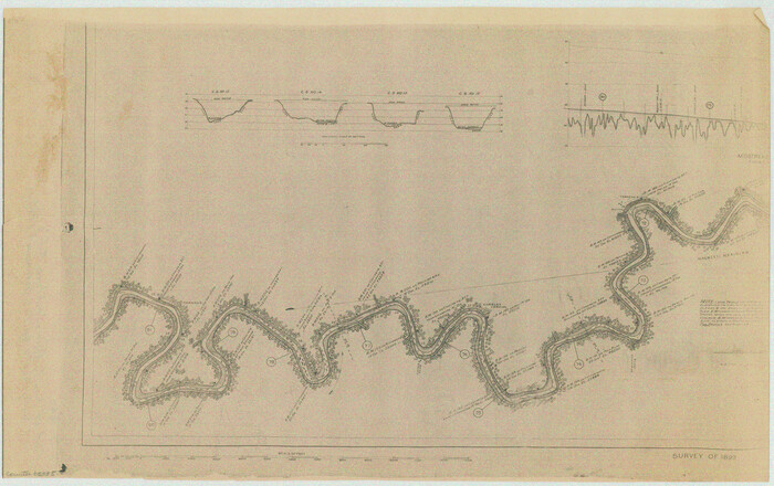
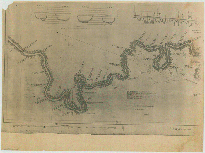
[Plat of Trinity River w/ Midstream Profile in Liberty County by US Government 1899]
Print $20.00
- Digital $50.00
[Plat of Trinity River w/ Midstream Profile in Liberty County by US Government 1899]
1899
Size: 11.5 x 18.3 inches
65335
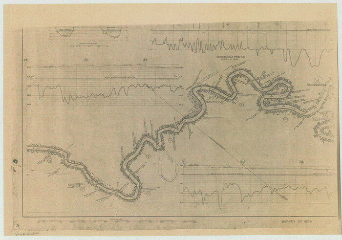
[Plat of Trinity River w/ Midstream Profile in Liberty County by US Government 1899]
Print $20.00
- Digital $50.00
[Plat of Trinity River w/ Midstream Profile in Liberty County by US Government 1899]
1899
Size: 10.8 x 18.3 inches
65336
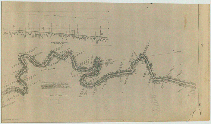
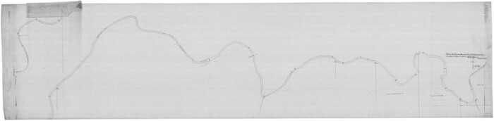
[Plat of Trinity River w/ Midstream Profile in Liberty County by US Government 1899]
Print $20.00
- Digital $50.00
[Plat of Trinity River w/ Midstream Profile in Liberty County by US Government 1899]
1899
Size: 12.3 x 16.7 inches
65337
[Plat of Trinity River w/ Midstream Profile in Liberty County by US Government 1899]
Print $20.00
- Digital $50.00
[Plat of Trinity River w/ Midstream Profile in Liberty County by US Government 1899]
1899
Size: 12.5 x 16.8 inches
65338
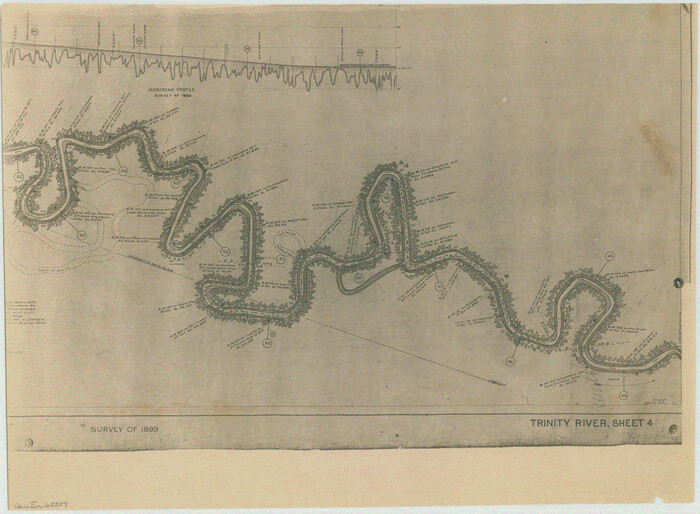
[Plat of Trinity River w/ Midstream Profile in Liberty County by US Government 1899]
Print $20.00
- Digital $50.00
[Plat of Trinity River w/ Midstream Profile in Liberty County by US Government 1899]
1899
Size: 12.8 x 17.6 inches
65339
[Plat of Trinity River w/ Midstream Profile in Liberty County by US Government 1899]
Print $20.00
- Digital $50.00
[Plat of Trinity River w/ Midstream Profile in Liberty County by US Government 1899]
1899
Size: 12.8 x 18.2 inches
65340
[Plat of Colorado River Survey, McCulloch County]
Print $40.00
- Digital $50.00
[Plat of Colorado River Survey, McCulloch County]
1918
Size: 40.3 x 159.2 inches
2462
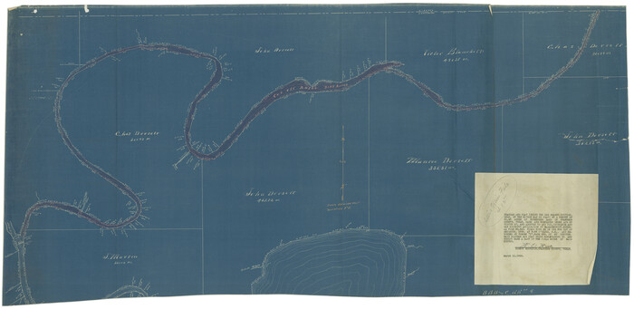
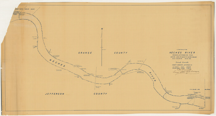
[Neches River Bed, Plat and Calculations]
Print $40.00
- Digital $50.00
[Neches River Bed, Plat and Calculations]
1928
Size: 27.3 x 51.0 inches
2466
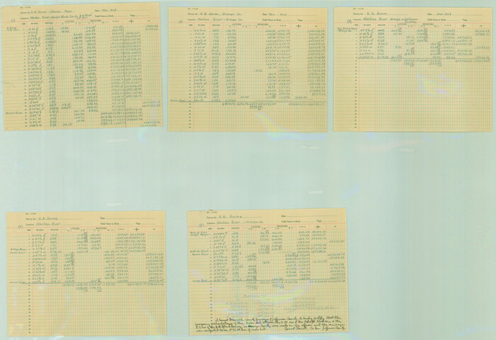
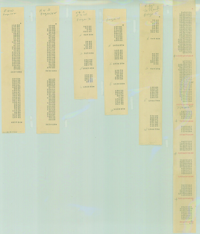
[Neches River Bed, Plat and Calculations]
Print $20.00
- Digital $50.00
[Neches River Bed, Plat and Calculations]
1928
Size: 25.6 x 37.2 inches
77100
[Neches River Bed, Plat and Calculations]
Print $20.00
- Digital $50.00
[Neches River Bed, Plat and Calculations]
1928
Size: 23.2 x 19.8 inches
77101
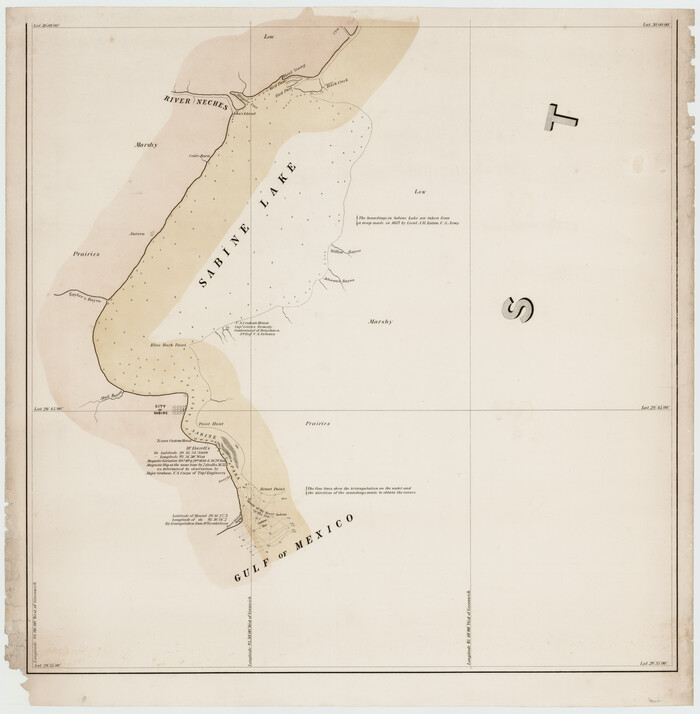
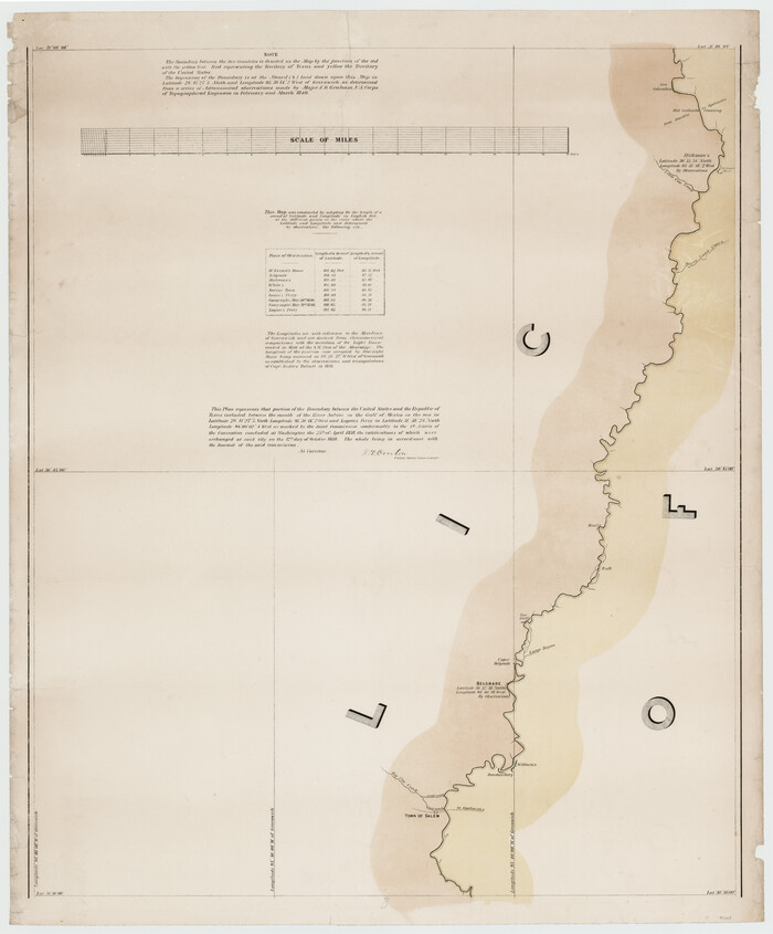
[Map of the River Sabine from its mouth on the Gulf of Mexico in the sea to Logan's Ferry in Latitude 31° 58' 24" North]
Print $20.00
- Digital $50.00
[Map of the River Sabine from its mouth on the Gulf of Mexico in the sea to Logan's Ferry in Latitude 31° 58' 24" North]
Size: 31.5 x 31.3 inches
94005
[Map of the River Sabine from its mouth on the Gulf of Mexico in the sea to Logan's Ferry in Latitude 31° 58' 24" North]
Print $20.00
- Digital $50.00
[Map of the River Sabine from its mouth on the Gulf of Mexico in the sea to Logan's Ferry in Latitude 31° 58' 24" North]
Size: 37.7 x 31.6 inches
94006
Wayland Crossing Sheet Robertson, Limestone and Leon Counties, Navasota River

Print $20.00
- Digital $50.00
Wayland Crossing Sheet Robertson, Limestone and Leon Counties, Navasota River
1934
Size: 43.9 x 40.9 inches
65072
Water-Shed of the Sulphur River in Texas Drainage Area

Print $4.00
- Digital $50.00
Water-Shed of the Sulphur River in Texas Drainage Area
1925
Size: 16.6 x 28.4 inches
65154
Water-Shed of the Pease River Drainage Area

Print $6.00
- Digital $50.00
Water-Shed of the Pease River Drainage Area
Size: 14.9 x 31.0 inches
65102
Water-Shed of the Colorado River

Print $40.00
- Digital $50.00
Water-Shed of the Colorado River
1925
Size: 37.1 x 79.8 inches
65261
Water-Shed of the Brazos River

Print $40.00
- Digital $50.00
Water-Shed of the Brazos River
1925
Size: 35.0 x 88.0 inches
65263
Water Valley Sheet, North Concho River, Tom Green County

Print $20.00
- Digital $50.00
Water Valley Sheet, North Concho River, Tom Green County
1937
Size: 23.6 x 19.1 inches
65305
Trinity River, Wire Bridge Sheet/Denton Creek

Print $6.00
- Digital $50.00
Trinity River, Wire Bridge Sheet/Denton Creek
1938
Size: 30.4 x 29.7 inches
65244
Trinity River, Wildcat Ferry Sheet

Print $20.00
- Digital $50.00
Trinity River, Wildcat Ferry Sheet
1928
Size: 41.5 x 40.9 inches
65182
Trinity River, White Rock Reservoir Sheet/White Rock Creek

Print $6.00
- Digital $50.00
Trinity River, White Rock Reservoir Sheet/White Rock Creek
1923
Size: 36.3 x 16.7 inches
65213
Trinity River, White Rock Creek Sheet

Print $6.00
- Digital $50.00
Trinity River, White Rock Creek Sheet
1923
Size: 33.0 x 24.2 inches
65198
Trinity River, Waxahachie Sheet/Waxahachie Creek

Print $6.00
- Digital $50.00
Trinity River, Waxahachie Sheet/Waxahachie Creek
1931
Size: 30.1 x 32.8 inches
65237
Trinity River, Watershed

Print $20.00
- Digital $50.00
Trinity River, Watershed
1925
Size: 46.9 x 40.5 inches
65255
[Victor Blanco's survey along the San Antonio River]
Print $2.00
- Digital $50.00
[Victor Blanco's survey along the San Antonio River]
-
Size
11.2 x 8.2 inches
-
Map/Doc
187
[Traverse up the Brazos and Colorado River showing distance from county site to county site]
Print $40.00
- Digital $50.00
[Traverse up the Brazos and Colorado River showing distance from county site to county site]
1871
-
Size
16.2 x 98.8 inches
-
Map/Doc
2054
-
Creation Date
1871
[Titles along the Trinity River]
Print $3.00
- Digital $50.00
[Titles along the Trinity River]
-
Size
10.6 x 15.8 inches
-
Map/Doc
175
[Sketch for Mineral Application 13436 - Cut-off Bayou]
Print $20.00
- Digital $50.00
[Sketch for Mineral Application 13436 - Cut-off Bayou]
1928
-
Size
21.3 x 44.3 inches
-
Map/Doc
65675
-
Creation Date
1928
[Sketch for Mineral Application 13436 - Cut-off Bayou]
Print $20.00
- Digital $50.00
[Sketch for Mineral Application 13436 - Cut-off Bayou]
1928
-
Size
44.1 x 21.6 inches
-
Map/Doc
65676
-
Creation Date
1928
[Plat of Trinity River w/ Midstream Profile in Liberty County by US Government 1899]
Print $20.00
- Digital $50.00
[Plat of Trinity River w/ Midstream Profile in Liberty County by US Government 1899]
1899
-
Size
11.5 x 18.3 inches
-
Map/Doc
65335
-
Creation Date
1899
[Plat of Trinity River w/ Midstream Profile in Liberty County by US Government 1899]
Print $20.00
- Digital $50.00
[Plat of Trinity River w/ Midstream Profile in Liberty County by US Government 1899]
1899
-
Size
10.8 x 18.3 inches
-
Map/Doc
65336
-
Creation Date
1899
[Plat of Trinity River w/ Midstream Profile in Liberty County by US Government 1899]
Print $20.00
- Digital $50.00
[Plat of Trinity River w/ Midstream Profile in Liberty County by US Government 1899]
1899
-
Size
12.3 x 16.7 inches
-
Map/Doc
65337
-
Creation Date
1899
[Plat of Trinity River w/ Midstream Profile in Liberty County by US Government 1899]
Print $20.00
- Digital $50.00
[Plat of Trinity River w/ Midstream Profile in Liberty County by US Government 1899]
1899
-
Size
12.5 x 16.8 inches
-
Map/Doc
65338
-
Creation Date
1899
[Plat of Trinity River w/ Midstream Profile in Liberty County by US Government 1899]
Print $20.00
- Digital $50.00
[Plat of Trinity River w/ Midstream Profile in Liberty County by US Government 1899]
1899
-
Size
12.8 x 17.6 inches
-
Map/Doc
65339
-
Creation Date
1899
[Plat of Trinity River w/ Midstream Profile in Liberty County by US Government 1899]
Print $20.00
- Digital $50.00
[Plat of Trinity River w/ Midstream Profile in Liberty County by US Government 1899]
1899
-
Size
12.8 x 18.2 inches
-
Map/Doc
65340
-
Creation Date
1899
[Plat of Colorado River Survey, McCulloch County]
Print $40.00
- Digital $50.00
[Plat of Colorado River Survey, McCulloch County]
1918
-
Size
40.3 x 159.2 inches
-
Map/Doc
2462
-
Creation Date
1918
[Pecos River Bed]
![2467, [Pecos River Bed], General Map Collection](https://historictexasmaps.com/wmedia_w700/maps/2467.tif.jpg)
Print $20.00
- Digital $50.00
[Pecos River Bed]
-
Size
16.6 x 39.8 inches
-
Map/Doc
2467
[Neches River Bed, Plat and Calculations]
Print $40.00
- Digital $50.00
[Neches River Bed, Plat and Calculations]
1928
-
Size
27.3 x 51.0 inches
-
Map/Doc
2466
-
Creation Date
1928
[Neches River Bed, Plat and Calculations]
Print $20.00
- Digital $50.00
[Neches River Bed, Plat and Calculations]
1928
-
Size
25.6 x 37.2 inches
-
Map/Doc
77100
-
Creation Date
1928
[Neches River Bed, Plat and Calculations]
Print $20.00
- Digital $50.00
[Neches River Bed, Plat and Calculations]
1928
-
Size
23.2 x 19.8 inches
-
Map/Doc
77101
-
Creation Date
1928
[Map of the River Sabine from its mouth on the Gulf of Mexico in the sea to Logan's Ferry in Latitude 31° 58' 24" North]
Print $20.00
- Digital $50.00
[Map of the River Sabine from its mouth on the Gulf of Mexico in the sea to Logan's Ferry in Latitude 31° 58' 24" North]
-
Size
31.5 x 31.3 inches
-
Map/Doc
94005
[Map of the River Sabine from its mouth on the Gulf of Mexico in the sea to Logan's Ferry in Latitude 31° 58' 24" North]
Print $20.00
- Digital $50.00
[Map of the River Sabine from its mouth on the Gulf of Mexico in the sea to Logan's Ferry in Latitude 31° 58' 24" North]
-
Size
37.7 x 31.6 inches
-
Map/Doc
94006
Wayland Crossing Sheet Robertson, Limestone and Leon Counties, Navasota River
Print $20.00
- Digital $50.00
Wayland Crossing Sheet Robertson, Limestone and Leon Counties, Navasota River
1934
-
Size
43.9 x 40.9 inches
-
Map/Doc
65072
-
Creation Date
1934
Water-Shed of the Sulphur River in Texas Drainage Area
Print $4.00
- Digital $50.00
Water-Shed of the Sulphur River in Texas Drainage Area
1925
-
Size
16.6 x 28.4 inches
-
Map/Doc
65154
-
Creation Date
1925
Water-Shed of the Pease River Drainage Area
Print $6.00
- Digital $50.00
Water-Shed of the Pease River Drainage Area
-
Size
14.9 x 31.0 inches
-
Map/Doc
65102
Water-Shed of the Colorado River
Print $40.00
- Digital $50.00
Water-Shed of the Colorado River
1925
-
Size
37.1 x 79.8 inches
-
Map/Doc
65261
-
Creation Date
1925
Water-Shed of the Brazos River
Print $40.00
- Digital $50.00
Water-Shed of the Brazos River
1925
-
Size
35.0 x 88.0 inches
-
Map/Doc
65263
-
Creation Date
1925
Water Valley Sheet, North Concho River, Tom Green County
Print $20.00
- Digital $50.00
Water Valley Sheet, North Concho River, Tom Green County
1937
-
Size
23.6 x 19.1 inches
-
Map/Doc
65305
-
Creation Date
1937
Trinity River, Wire Bridge Sheet/Denton Creek
Print $6.00
- Digital $50.00
Trinity River, Wire Bridge Sheet/Denton Creek
1938
-
Size
30.4 x 29.7 inches
-
Map/Doc
65244
-
Creation Date
1938
Trinity River, Wildcat Ferry Sheet
Print $20.00
- Digital $50.00
Trinity River, Wildcat Ferry Sheet
1928
-
Size
41.5 x 40.9 inches
-
Map/Doc
65182
-
Creation Date
1928
Trinity River, White Rock Reservoir Sheet/White Rock Creek
Print $6.00
- Digital $50.00
Trinity River, White Rock Reservoir Sheet/White Rock Creek
1923
-
Size
36.3 x 16.7 inches
-
Map/Doc
65213
-
Creation Date
1923
Trinity River, White Rock Creek Sheet
Print $6.00
- Digital $50.00
Trinity River, White Rock Creek Sheet
1923
-
Size
33.0 x 24.2 inches
-
Map/Doc
65198
-
Creation Date
1923
Trinity River, Waxahachie Sheet/Waxahachie Creek
Print $6.00
- Digital $50.00
Trinity River, Waxahachie Sheet/Waxahachie Creek
1931
-
Size
30.1 x 32.8 inches
-
Map/Doc
65237
-
Creation Date
1931
Trinity River, Watershed
Print $20.00
- Digital $50.00
Trinity River, Watershed
1925
-
Size
46.9 x 40.5 inches
-
Map/Doc
65255
-
Creation Date
1925