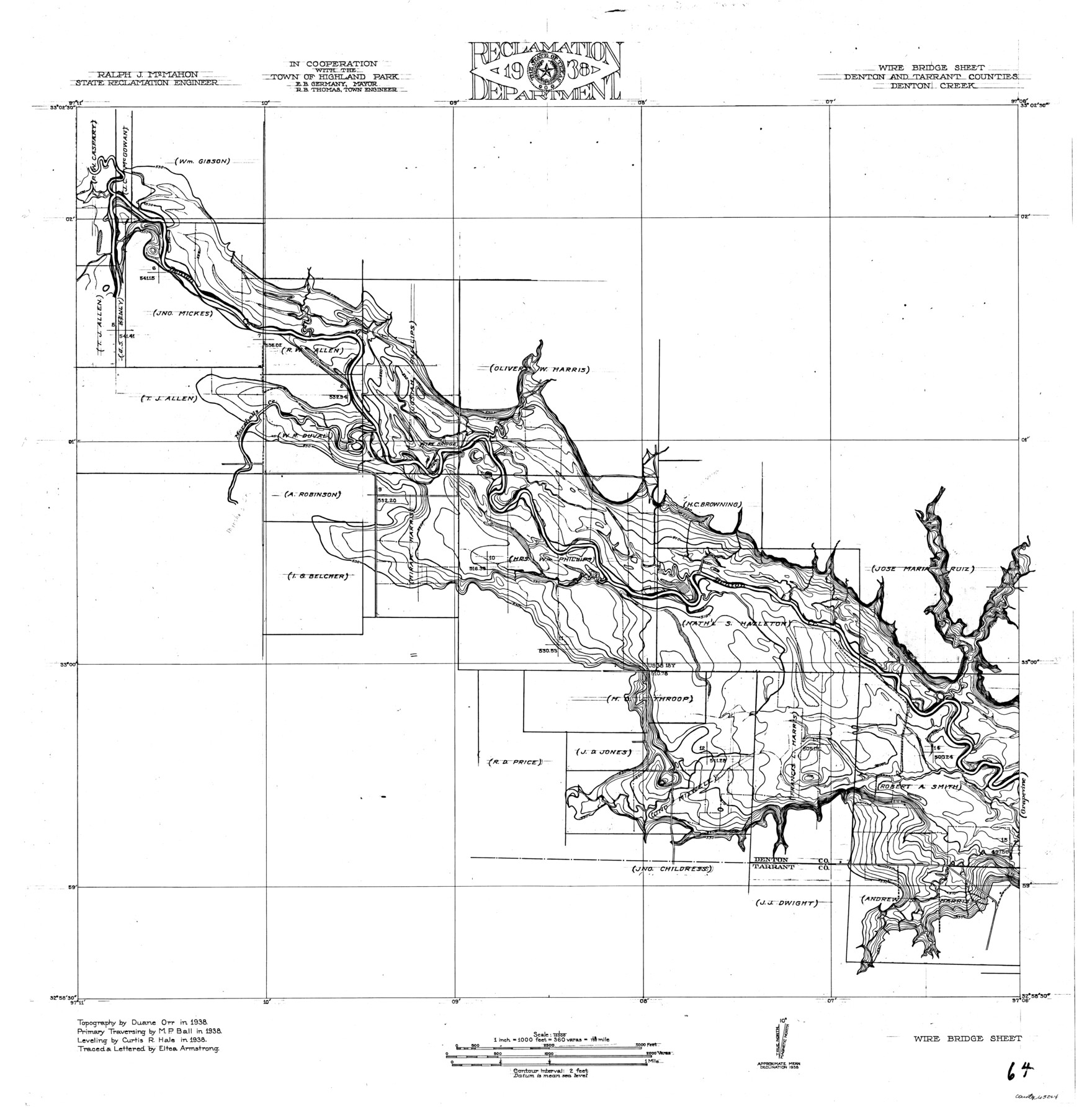
Trinity River, Wire Bridge Sheet/Denton Creek
-
Map/Doc
65244
-
Collection
General Map Collection
-
Object Dates
1938 (Creation Date)
-
People and Organizations
Texas State Reclamation Department (Publisher)
Eltea Armstrong (Draftsman)
Eltea Armstrong (Compiler)
Curtis R. Hale (Surveyor/Engineer)
Duane Orr (Surveyor/Engineer)
M.P. Ball (Surveyor/Engineer)
-
Counties
Denton Tarrant
-
Subjects
River Surveys Topographic
-
Height x Width
30.4 x 29.7 inches
77.2 x 75.4 cm
-
Comments
Wire Bridge Sheet located west of Grapevine
Part of: General Map Collection
Plat of survey in the North West portion of the Ramsey State Farm

Print $20.00
- Digital $50.00
Plat of survey in the North West portion of the Ramsey State Farm
1942
Size 25.9 x 30.4 inches
Map/Doc 94282
Randall County Rolled Sketch 10

Print $20.00
- Digital $50.00
Randall County Rolled Sketch 10
Size 26.9 x 22.6 inches
Map/Doc 7431
San Augustine County Sketch File 20

Print $82.00
- Digital $50.00
San Augustine County Sketch File 20
1951
Size 8.9 x 14.4 inches
Map/Doc 35680
Jasper County Working Sketch 21

Print $20.00
- Digital $50.00
Jasper County Working Sketch 21
1941
Size 13.1 x 21.4 inches
Map/Doc 66483
Val Verde County Rolled Sketch 62

Print $40.00
- Digital $50.00
Val Verde County Rolled Sketch 62
1956
Size 34.6 x 52.1 inches
Map/Doc 10081
Fort Bend County Working Sketch 17

Print $20.00
- Digital $50.00
Fort Bend County Working Sketch 17
1955
Size 25.1 x 31.1 inches
Map/Doc 69223
Liberty County Working Sketch 24

Print $20.00
- Digital $50.00
Liberty County Working Sketch 24
1941
Size 19.0 x 14.0 inches
Map/Doc 70483
Right of Way and Track Map, Texas & New Orleans R.R. Co. operated by the T. & N. O. R.R. Co., Dallas-Sabine Branch

Print $40.00
- Digital $50.00
Right of Way and Track Map, Texas & New Orleans R.R. Co. operated by the T. & N. O. R.R. Co., Dallas-Sabine Branch
1918
Size 24.6 x 56.4 inches
Map/Doc 64631
Rains County Working Sketch 9

Print $20.00
- Digital $50.00
Rains County Working Sketch 9
1976
Size 35.8 x 31.9 inches
Map/Doc 71835
Map of Hidalgo County

Print $20.00
- Digital $50.00
Map of Hidalgo County
1896
Size 44.7 x 26.7 inches
Map/Doc 4978
Duval County Rolled Sketch OS

Print $20.00
- Digital $50.00
Duval County Rolled Sketch OS
1903
Size 36.0 x 31.9 inches
Map/Doc 8803
Reeves County Rolled Sketch 21

Print $20.00
- Digital $50.00
Reeves County Rolled Sketch 21
1978
Size 27.6 x 27.6 inches
Map/Doc 7489
You may also like
Guadalupe County Sketch File 7a

Print $4.00
- Digital $50.00
Guadalupe County Sketch File 7a
1873
Size 10.2 x 8.2 inches
Map/Doc 24668
Edwards County Rolled Sketch 8

Print $20.00
- Digital $50.00
Edwards County Rolled Sketch 8
1891
Size 16.0 x 18.7 inches
Map/Doc 5801
Frio County Working Sketch 7

Print $20.00
- Digital $50.00
Frio County Working Sketch 7
1942
Size 26.5 x 43.3 inches
Map/Doc 69281
Hardeman County

Print $20.00
- Digital $50.00
Hardeman County
1935
Size 44.4 x 41.4 inches
Map/Doc 73170
Brewster County Sketch File NS-13

Print $4.00
- Digital $50.00
Brewster County Sketch File NS-13
1955
Size 11.1 x 8.8 inches
Map/Doc 16220
[Capitol Leagues 661-729]
![92979, [Capitol Leagues 661-729], Twichell Survey Records](https://historictexasmaps.com/wmedia_w700/maps/92979-1.tif.jpg)
Print $20.00
- Digital $50.00
[Capitol Leagues 661-729]
Size 24.2 x 24.9 inches
Map/Doc 92979
Flight Mission No. BRE-1P, Frame 67, Nueces County

Print $20.00
- Digital $50.00
Flight Mission No. BRE-1P, Frame 67, Nueces County
1956
Size 18.7 x 22.4 inches
Map/Doc 86649
Shores of Laguna Madre, Texas from Triangulation Station Camp No. 2 to Triangulation Station Peat ID

Print $40.00
- Digital $50.00
Shores of Laguna Madre, Texas from Triangulation Station Camp No. 2 to Triangulation Station Peat ID
1882
Size 54.8 x 32.3 inches
Map/Doc 73482
Clay County Sketch File 41

Print $6.00
- Digital $50.00
Clay County Sketch File 41
1949
Size 14.2 x 8.6 inches
Map/Doc 18482
Brewster County Working Sketch 72

Print $20.00
- Digital $50.00
Brewster County Working Sketch 72
1965
Size 20.7 x 24.6 inches
Map/Doc 67672
Nueces County Rolled Sketch 105

Print $96.00
Nueces County Rolled Sketch 105
1986
Size 18.1 x 25.4 inches
Map/Doc 7086
Howard County Boundary File 4b

Print $24.00
- Digital $50.00
Howard County Boundary File 4b
Size 11.3 x 8.9 inches
Map/Doc 55168