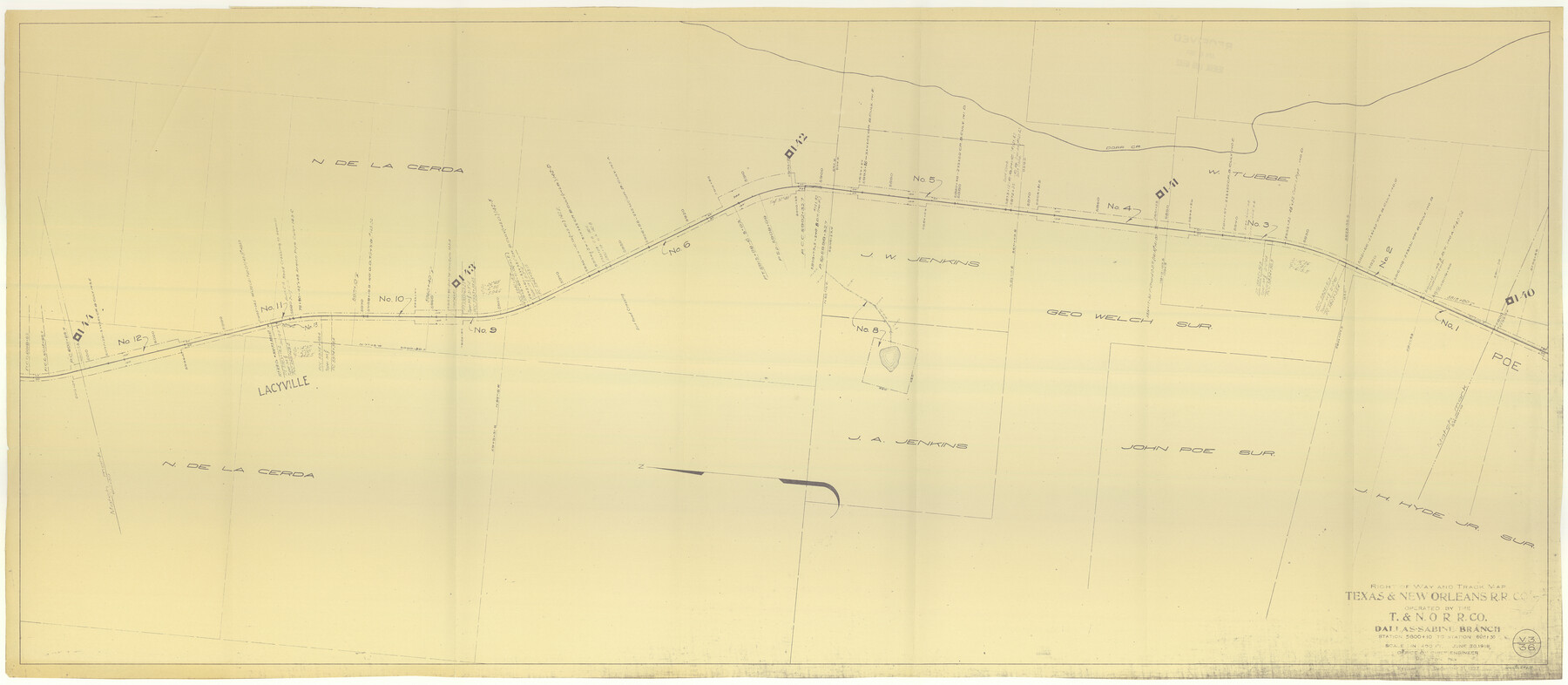
Right of Way and Track Map, Texas & New Orleans R.R. Co. operated by the T. & N. O. R.R. Co., Dallas-Sabine Branch
Station 5800+10 to Station 6011+30
Z-2-187
-
Map/Doc
64631
-
Collection
General Map Collection
-
Object Dates
1927/12/31 (Revision Date)
1918/6/30 (Creation Date)
-
Counties
Nacogdoches
-
Subjects
Railroads
-
Height x Width
24.6 x 56.4 inches
62.5 x 143.3 cm
-
Medium
blueprint/diazo
-
Scale
1" = 400 feet
-
Comments
See counter nos. 64629 through 64630 and 64632 for other sheets.
-
Features
T&NO
Dorr Creek
Lacyville
Part of: General Map Collection
Newton County Rolled Sketch 16

Print $20.00
- Digital $50.00
Newton County Rolled Sketch 16
Size 30.5 x 21.9 inches
Map/Doc 6846
Stonewall County Working Sketch 24

Print $20.00
- Digital $50.00
Stonewall County Working Sketch 24
1973
Size 27.1 x 30.9 inches
Map/Doc 62331
Plat of a survey on Padre Island in Willacy County surveyed for South Padre Development Corporation by Settles and Claunch

Print $40.00
- Digital $50.00
Plat of a survey on Padre Island in Willacy County surveyed for South Padre Development Corporation by Settles and Claunch
1966
Size 78.6 x 41.6 inches
Map/Doc 61427
Lavaca County Sketch File 23

Print $20.00
- Digital $50.00
Lavaca County Sketch File 23
1986
Size 14.0 x 8.6 inches
Map/Doc 29668

Jefferson County Rolled Sketch 60

Print $20.00
- Digital $50.00
Jefferson County Rolled Sketch 60
1885
Size 34.0 x 35.9 inches
Map/Doc 9316
Polk County Working Sketch 18

Print $20.00
- Digital $50.00
Polk County Working Sketch 18
1949
Size 25.4 x 23.3 inches
Map/Doc 71633
Flight Mission No. BRE-1P, Frame 27, Nueces County

Print $20.00
- Digital $50.00
Flight Mission No. BRE-1P, Frame 27, Nueces County
1956
Size 18.5 x 22.4 inches
Map/Doc 86622
Flight Mission No. BRA-16M, Frame 87, Jefferson County

Print $20.00
- Digital $50.00
Flight Mission No. BRA-16M, Frame 87, Jefferson County
1953
Size 18.6 x 22.3 inches
Map/Doc 85699
Trinity County Sketch File 23

Print $26.00
- Digital $50.00
Trinity County Sketch File 23
1861
Size 6.9 x 8.3 inches
Map/Doc 38552
Flight Mission No. DCL-6C, Frame 133, Kenedy County

Print $20.00
- Digital $50.00
Flight Mission No. DCL-6C, Frame 133, Kenedy County
1943
Size 18.6 x 22.3 inches
Map/Doc 85963
Kendall County Sketch File 16a

Print $40.00
- Digital $50.00
Kendall County Sketch File 16a
1891
Size 15.3 x 13.7 inches
Map/Doc 28707
You may also like
Limestone County Sketch File 10

Print $4.00
- Digital $50.00
Limestone County Sketch File 10
Size 8.4 x 9.4 inches
Map/Doc 30171
[Plat Showing San Gabriel & 24th Street Intersection, Outlot 4, Travis County, Texas]
![75795, [Plat Showing San Gabriel & 24th Street Intersection, Outlot 4, Travis County, Texas], Maddox Collection](https://historictexasmaps.com/wmedia_w700/maps/75795.tif.jpg)
Print $2.00
- Digital $50.00
[Plat Showing San Gabriel & 24th Street Intersection, Outlot 4, Travis County, Texas]
Size 11.4 x 8.7 inches
Map/Doc 75795
Zapata County Boundary File 2

Print $12.00
- Digital $50.00
Zapata County Boundary File 2
Size 14.4 x 8.8 inches
Map/Doc 60228
Lampasas County Sketch File 7

Print $4.00
- Digital $50.00
Lampasas County Sketch File 7
1871
Size 8.4 x 8.2 inches
Map/Doc 29402
Wood County Sketch File 3

Print $4.00
- Digital $50.00
Wood County Sketch File 3
1848
Size 10.1 x 8.1 inches
Map/Doc 40633
Baylor County Rolled Sketch WAJ

Print $20.00
- Digital $50.00
Baylor County Rolled Sketch WAJ
Size 22.0 x 17.0 inches
Map/Doc 5132
Webb County Sketch File 13

Print $4.00
- Digital $50.00
Webb County Sketch File 13
1877
Size 12.9 x 8.1 inches
Map/Doc 39801
Stephens County Working Sketch 2

Print $20.00
- Digital $50.00
Stephens County Working Sketch 2
1918
Size 17.1 x 21.1 inches
Map/Doc 63945
Floyd County Sketch File 30

Print $20.00
- Digital $50.00
Floyd County Sketch File 30
Size 12.6 x 33.9 inches
Map/Doc 11489
Ellis County Sketch File 6

Print $24.00
- Digital $50.00
Ellis County Sketch File 6
Size 12.3 x 8.2 inches
Map/Doc 21836
Cochran County Boundary File 5

Print $12.00
- Digital $50.00
Cochran County Boundary File 5
Size 4.2 x 8.8 inches
Map/Doc 51556
Reagan County Sketch File 28

Print $20.00
- Digital $50.00
Reagan County Sketch File 28
1951
Size 29.6 x 21.7 inches
Map/Doc 12224