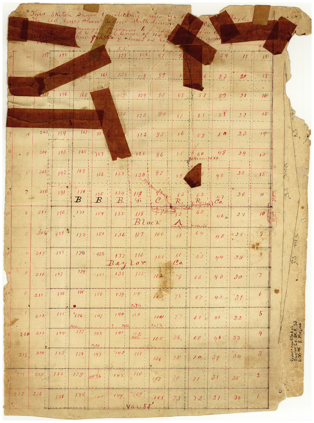
Baylor County Rolled Sketch WAJ
[Sketch showing conflicting lines in B.B.B. & C. R.R. Co. Block A]
-
Map/Doc
5132
-
Collection
General Map Collection
-
People and Organizations
W.A. Jones (Surveyor/Engineer)
A.D. Kerr (Surveyor/Engineer)
-
Counties
Baylor
-
Subjects
Surveying Rolled Sketch
-
Height x Width
22.0 x 17.0 inches
55.9 x 43.2 cm
-
Medium
paper, manuscript
-
Comments
See Baylor County Sketch File 32 (14238) for surveyor’s report.
Related maps
Baylor County Sketch File 32

Print $10.00
- Digital $50.00
Baylor County Sketch File 32
Size 10.2 x 8.2 inches
Map/Doc 14238
Part of: General Map Collection
Harris County Sketch File 43

Print $6.00
- Digital $50.00
Harris County Sketch File 43
1905
Size 11.1 x 8.7 inches
Map/Doc 25440
Crockett County Rolled Sketch 73

Print $20.00
- Digital $50.00
Crockett County Rolled Sketch 73
1949
Size 10.4 x 23.6 inches
Map/Doc 5614
Flight Mission No. BRE-1P, Frame 48, Nueces County

Print $20.00
- Digital $50.00
Flight Mission No. BRE-1P, Frame 48, Nueces County
1956
Size 18.4 x 22.1 inches
Map/Doc 86637
Duval County Rolled Sketch 27

Print $40.00
- Digital $50.00
Duval County Rolled Sketch 27
Size 14.6 x 50.6 inches
Map/Doc 8814
Hunt County Sketch File 12

Print $40.00
- Digital $50.00
Hunt County Sketch File 12
1852
Size 12.7 x 16.0 inches
Map/Doc 27104
Bosque County Sketch File 12

Print $4.00
- Digital $50.00
Bosque County Sketch File 12
1863
Size 12.7 x 8.2 inches
Map/Doc 14761
Tarrant County Working Sketch 8

Print $20.00
- Digital $50.00
Tarrant County Working Sketch 8
1982
Size 33.2 x 19.7 inches
Map/Doc 62425
Real County Sketch File 10

Print $6.00
- Digital $50.00
Real County Sketch File 10
1932
Size 10.3 x 15.0 inches
Map/Doc 35063
Harris County Historic Topographic 24

Print $20.00
- Digital $50.00
Harris County Historic Topographic 24
1916
Size 29.2 x 22.9 inches
Map/Doc 65835
McMullen County Sketch File 28

Print $20.00
- Digital $50.00
McMullen County Sketch File 28
1884
Size 24.8 x 28.1 inches
Map/Doc 12061
United States - Gulf Coast - Galveston to Rio Grande

Print $20.00
- Digital $50.00
United States - Gulf Coast - Galveston to Rio Grande
1941
Size 26.7 x 18.5 inches
Map/Doc 72751
[Aerial Photograph of Galveston Island and the Gulf of Mexico]
![83434, [Aerial Photograph of Galveston Island and the Gulf of Mexico], General Map Collection](https://historictexasmaps.com/wmedia_w700/maps/83434.tif.jpg)
Print $20.00
- Digital $50.00
[Aerial Photograph of Galveston Island and the Gulf of Mexico]
1956
Size 15.5 x 12.7 inches
Map/Doc 83434
You may also like

Jefferson County Working Sketch 8

Print $20.00
- Digital $50.00
Jefferson County Working Sketch 8
1931
Size 34.9 x 18.2 inches
Map/Doc 66551
Map showing the Houston & Texas Central Railroad and its connections

Print $20.00
Map showing the Houston & Texas Central Railroad and its connections
1867
Size 22.0 x 25.2 inches
Map/Doc 93604
Real County Working Sketch 65

Print $20.00
- Digital $50.00
Real County Working Sketch 65
1969
Size 31.1 x 23.4 inches
Map/Doc 71957
Edwards County Sketch File 23

Print $8.00
- Digital $50.00
Edwards County Sketch File 23
1881
Size 14.4 x 9.0 inches
Map/Doc 21747
[Surveys on the south side of the Canadian River]
![91788, [Surveys on the south side of the Canadian River], Twichell Survey Records](https://historictexasmaps.com/wmedia_w700/maps/91788-1.tif.jpg)
Print $3.00
- Digital $50.00
[Surveys on the south side of the Canadian River]
Size 11.2 x 15.9 inches
Map/Doc 91788
Atascosa County Sketch File 5

Print $8.00
- Digital $50.00
Atascosa County Sketch File 5
1856
Size 8.2 x 12.4 inches
Map/Doc 13748
Reagan County Boundary File 1c

Print $56.00
- Digital $50.00
Reagan County Boundary File 1c
Size 9.2 x 8.2 inches
Map/Doc 58171
The Texas and Oklahoma Official Railway and Hotel Guide Map

Print $20.00
The Texas and Oklahoma Official Railway and Hotel Guide Map
1906
Size 23.5 x 23.4 inches
Map/Doc 79316
Dickens County Working Sketch 3

Print $20.00
- Digital $50.00
Dickens County Working Sketch 3
Size 17.5 x 15.3 inches
Map/Doc 68650
McCulloch County Sketch File 8

Print $4.00
- Digital $50.00
McCulloch County Sketch File 8
1904
Size 11.3 x 8.7 inches
Map/Doc 31182
Travis County Boundary File 28

Print $8.00
- Digital $50.00
Travis County Boundary File 28
Size 14.7 x 9.0 inches
Map/Doc 59464