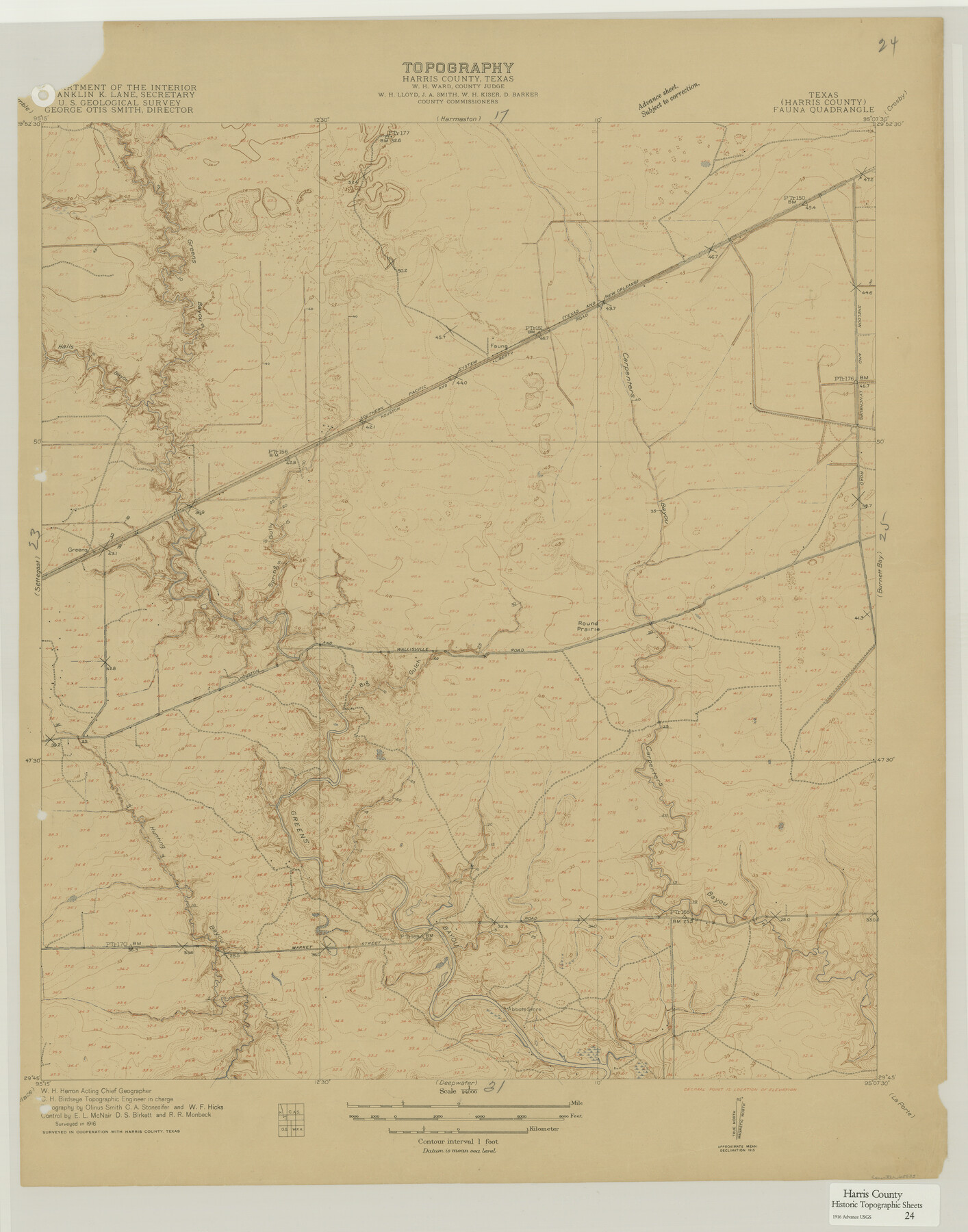
Harris County Historic Topographic 24
Fauna Quadrangle
-
Map/Doc
65835
-
Collection
General Map Collection
-
Object Dates
1916 (Creation Date)
-
People and Organizations
U. S. Geological Survey (Publisher)
-
Counties
Harris
-
Subjects
Topographic
-
Height x Width
29.2 x 22.9 inches
74.2 x 58.2 cm
Part of: General Map Collection
Map of Extension Line from the Brazos River to the Waters of the Colorado River of the Memphis, El Paso & Pacific R.R. Company Land Reserve

Print $40.00
- Digital $50.00
Map of Extension Line from the Brazos River to the Waters of the Colorado River of the Memphis, El Paso & Pacific R.R. Company Land Reserve
1858
Size 16.8 x 82.9 inches
Map/Doc 64093
Leon County Working Sketch 41

Print $40.00
- Digital $50.00
Leon County Working Sketch 41
1980
Size 61.2 x 43.2 inches
Map/Doc 70440
Martin County Rolled Sketch 10A

Print $20.00
- Digital $50.00
Martin County Rolled Sketch 10A
1994
Size 18.3 x 24.5 inches
Map/Doc 6671
Texas Gulf Coast Map from the Sabine River to the Rio Grande as subdivided for mineral development

Print $40.00
- Digital $50.00
Texas Gulf Coast Map from the Sabine River to the Rio Grande as subdivided for mineral development
1948
Size 60.9 x 36.7 inches
Map/Doc 2909

Val Verde County Working Sketch 72

Print $20.00
- Digital $50.00
Val Verde County Working Sketch 72
1967
Size 19.6 x 23.0 inches
Map/Doc 72207
Map of the Lands Surveyed by the Memphis, El Paso & Pacific R.R. Company

Print $20.00
- Digital $50.00
Map of the Lands Surveyed by the Memphis, El Paso & Pacific R.R. Company
1859
Size 15.0 x 30.0 inches
Map/Doc 2219
Tom Green County Rolled Sketch 48

Print $20.00
- Digital $50.00
Tom Green County Rolled Sketch 48
1884
Size 14.3 x 22.7 inches
Map/Doc 8009
[County table portion of 1879 State of Texas map by Pressler & Langermann]
![3102, [County table portion of 1879 State of Texas map by Pressler & Langermann], General Map Collection](https://historictexasmaps.com/wmedia_w700/maps/3102-1.tif.jpg)
Print $20.00
- Digital $50.00
[County table portion of 1879 State of Texas map by Pressler & Langermann]
1879
Size 15.0 x 23.6 inches
Map/Doc 3102
Flight Mission No. CRK-5P, Frame 161, Refugio County

Print $20.00
- Digital $50.00
Flight Mission No. CRK-5P, Frame 161, Refugio County
1956
Size 18.5 x 22.4 inches
Map/Doc 86942
San Augustine Co.

Print $40.00
- Digital $50.00
San Augustine Co.
1949
Size 48.9 x 32.2 inches
Map/Doc 95632
A Geographically Correct Map of the State of Texas

Print $20.00
- Digital $50.00
A Geographically Correct Map of the State of Texas
1876
Size 20.4 x 21.9 inches
Map/Doc 95362
You may also like
[B. S. & F. Block 9]
![91812, [B. S. & F. Block 9], Twichell Survey Records](https://historictexasmaps.com/wmedia_w700/maps/91812-1.tif.jpg)
Print $20.00
- Digital $50.00
[B. S. & F. Block 9]
Size 38.0 x 18.6 inches
Map/Doc 91812
Montgomery County Sketch File 21

Print $8.00
- Digital $50.00
Montgomery County Sketch File 21
1934
Size 9.0 x 13.2 inches
Map/Doc 31856
Sterling County Sketch File 3

Print $20.00
- Digital $50.00
Sterling County Sketch File 3
Size 14.5 x 34.8 inches
Map/Doc 12355
University of Texas System University Lands

Print $20.00
- Digital $50.00
University of Texas System University Lands
1937
Size 23.3 x 17.6 inches
Map/Doc 93237
Andrews County Rolled Sketch 43

Print $20.00
- Digital $50.00
Andrews County Rolled Sketch 43
Size 26.1 x 41.0 inches
Map/Doc 77183
Archer County Working Sketch 17

Print $3.00
- Digital $50.00
Archer County Working Sketch 17
1951
Size 10.7 x 12.2 inches
Map/Doc 67158
Bell County Sketch File 12a

Print $6.00
- Digital $50.00
Bell County Sketch File 12a
1853
Size 12.8 x 8.0 inches
Map/Doc 14387
Tyler County Sketch File 6

Print $6.00
- Digital $50.00
Tyler County Sketch File 6
1848
Size 6.0 x 7.1 inches
Map/Doc 38630
Kleberg County Rolled Sketch 10-14

Print $20.00
- Digital $50.00
Kleberg County Rolled Sketch 10-14
1951
Size 38.0 x 33.2 inches
Map/Doc 9404
Newton County Rolled Sketch 7

Print $20.00
- Digital $50.00
Newton County Rolled Sketch 7
1943
Size 21.4 x 37.2 inches
Map/Doc 6843
Bailey County Working Sketch 3

Print $20.00
- Digital $50.00
Bailey County Working Sketch 3
1922
Size 17.3 x 28.0 inches
Map/Doc 67590
Howard County Boundary File 3a

Print $62.00
- Digital $50.00
Howard County Boundary File 3a
Size 3.9 x 8.7 inches
Map/Doc 55155