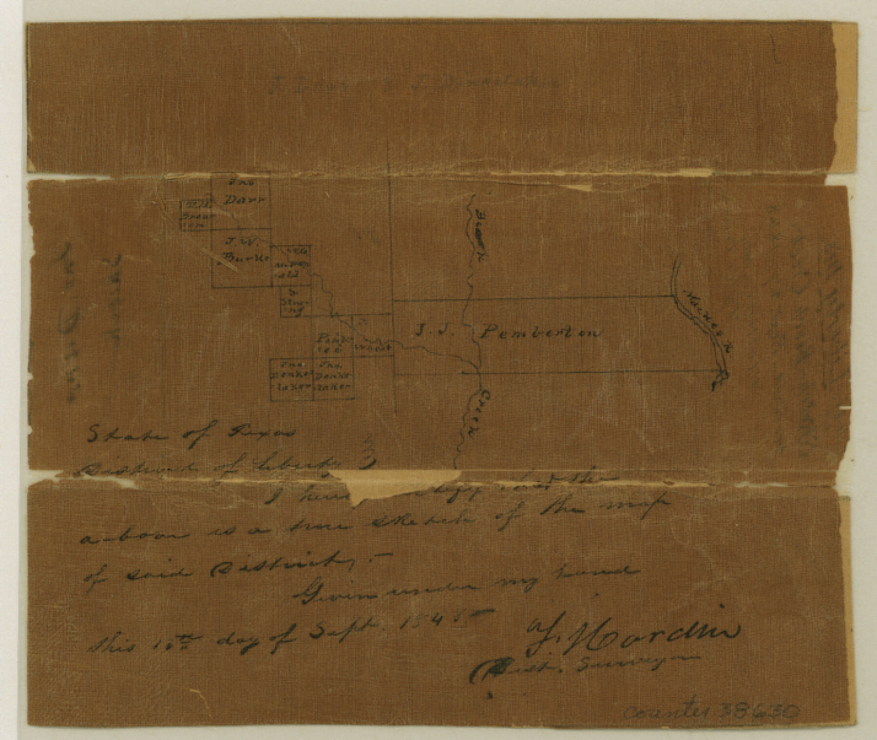
Tyler County Sketch File 6
[Sketch of surveys around Beech Creek and the Pemberton survey on the Neches River in the east part of the county]
-
Map/Doc
38630
-
Collection
General Map Collection
-
Object Dates
9/12/1848 (Creation Date)
9/27/1848 (File Date)
-
People and Organizations
F. Hardin (Surveyor/Engineer)
-
Counties
Tyler
-
Subjects
Surveying Sketch File
-
Height x Width
6.0 x 7.1 inches
15.2 x 18.0 cm
-
Medium
paper, manuscript
-
Features
Beech Creek
Naches [sic] River
Part of: General Map Collection
San Augustine County Sketch File 21

Print $4.00
- Digital $50.00
San Augustine County Sketch File 21
1873
Size 12.8 x 7.9 inches
Map/Doc 35685
Culberson County Working Sketch 60

Print $40.00
- Digital $50.00
Culberson County Working Sketch 60
1974
Size 74.7 x 32.7 inches
Map/Doc 68514
Van Zandt County Rolled Sketch 11

Print $20.00
- Digital $50.00
Van Zandt County Rolled Sketch 11
2019
Size 23.6 x 36.0 inches
Map/Doc 95717
El Paso County Working Sketch 34

Print $40.00
- Digital $50.00
El Paso County Working Sketch 34
1974
Size 53.4 x 34.7 inches
Map/Doc 69056
Kendall County Sketch File 14

Print $4.00
- Digital $50.00
Kendall County Sketch File 14
1860
Size 8.1 x 10.2 inches
Map/Doc 28701
Anderson County Working Sketch 22

Print $20.00
- Digital $50.00
Anderson County Working Sketch 22
1954
Size 22.7 x 24.2 inches
Map/Doc 67022

Matagorda County Sketch File 2

Print $6.00
- Digital $50.00
Matagorda County Sketch File 2
1866
Size 15.9 x 10.8 inches
Map/Doc 30730
Webb County Rolled Sketch 78A

Print $20.00
- Digital $50.00
Webb County Rolled Sketch 78A
Size 28.4 x 23.0 inches
Map/Doc 90053
Hall County Rolled Sketch 6

Print $20.00
- Digital $50.00
Hall County Rolled Sketch 6
Size 24.9 x 41.2 inches
Map/Doc 6050
Starr County Rolled Sketch 33

Print $20.00
- Digital $50.00
Starr County Rolled Sketch 33
1944
Size 21.9 x 30.8 inches
Map/Doc 7830
Freestone County Working Sketch 27

Print $20.00
- Digital $50.00
Freestone County Working Sketch 27
1986
Size 28.0 x 30.9 inches
Map/Doc 69269
You may also like
No. 2 Chart of Corpus Christi Pass, Texas

Print $20.00
- Digital $50.00
No. 2 Chart of Corpus Christi Pass, Texas
1878
Size 18.3 x 27.4 inches
Map/Doc 73018
General Highway Map, Liberty County, Texas

Print $20.00
General Highway Map, Liberty County, Texas
1961
Size 18.1 x 24.6 inches
Map/Doc 79571

Crockett County Rolled Sketch 31

Print $40.00
- Digital $50.00
Crockett County Rolled Sketch 31
Size 58.1 x 50.0 inches
Map/Doc 8716
Upton County Working Sketch 23

Print $20.00
- Digital $50.00
Upton County Working Sketch 23
1953
Size 21.4 x 20.0 inches
Map/Doc 69519
Jeff Davis County Rolled Sketch 20

Print $20.00
- Digital $50.00
Jeff Davis County Rolled Sketch 20
1944
Size 22.7 x 19.6 inches
Map/Doc 7724
Map of Terry County

Print $20.00
- Digital $50.00
Map of Terry County
1902
Size 45.6 x 40.8 inches
Map/Doc 16893
Trinity River, White Rock Creek Sheet

Print $6.00
- Digital $50.00
Trinity River, White Rock Creek Sheet
1923
Size 33.0 x 24.2 inches
Map/Doc 65198
Brazoria County Sketch File 18

Print $18.00
- Digital $50.00
Brazoria County Sketch File 18
Size 14.5 x 8.9 inches
Map/Doc 14989

Map of Reeves County

Print $20.00
- Digital $50.00
Map of Reeves County
1892
Size 47.2 x 35.4 inches
Map/Doc 78401
Pecos County Sketch File 76

Print $4.00
- Digital $50.00
Pecos County Sketch File 76
1943
Size 11.2 x 8.8 inches
Map/Doc 33907