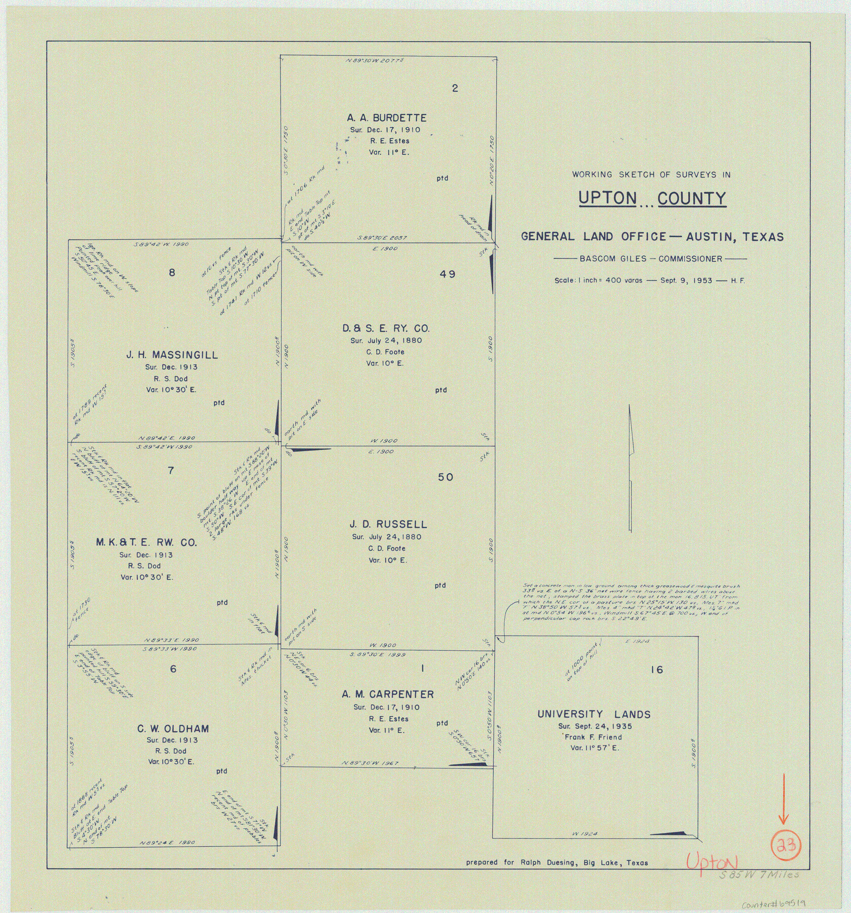
Upton County Working Sketch 23
-
Map/Doc
69519
-
Collection
General Map Collection
-
Object Dates
9/9/1953 (Creation Date)
-
People and Organizations
Herman Forbes (Draftsman)
-
Counties
Upton
-
Subjects
Surveying Working Sketch
-
Height x Width
21.4 x 20.0 inches
54.4 x 50.8 cm
-
Scale
1" = 400 varas
Part of: General Map Collection
Brewster County Sketch File N-2

Print $44.00
- Digital $50.00
Brewster County Sketch File N-2
1881
Size 8.2 x 12.8 inches
Map/Doc 15567
Loving County Working Sketch 18

Print $40.00
- Digital $50.00
Loving County Working Sketch 18
1978
Size 65.2 x 43.2 inches
Map/Doc 70652
Terrell County Sketch File 22W

Print $20.00
- Digital $50.00
Terrell County Sketch File 22W
Size 19.6 x 21.7 inches
Map/Doc 12423
Harris County Sketch File 14

Print $20.00
- Digital $50.00
Harris County Sketch File 14
Size 17.4 x 18.4 inches
Map/Doc 11649
Childress County Rolled Sketch 5A

Print $20.00
- Digital $50.00
Childress County Rolled Sketch 5A
Size 32.9 x 21.9 inches
Map/Doc 5440
Flight Mission No. CGI-1N, Frame 136, Cameron County

Print $20.00
- Digital $50.00
Flight Mission No. CGI-1N, Frame 136, Cameron County
1955
Size 17.2 x 18.5 inches
Map/Doc 84492
Lamar County Working Sketch 4

Print $20.00
- Digital $50.00
Lamar County Working Sketch 4
1920
Size 14.4 x 25.1 inches
Map/Doc 70265
Runnels County Working Sketch 22

Print $20.00
- Digital $50.00
Runnels County Working Sketch 22
1951
Size 16.2 x 28.1 inches
Map/Doc 63618
Sutton County Rolled Sketch 59

Print $40.00
- Digital $50.00
Sutton County Rolled Sketch 59
1960
Size 86.1 x 42.5 inches
Map/Doc 9977
Culberson County Rolled Sketch 18

Print $6.00
- Digital $50.00
Culberson County Rolled Sketch 18
1911
Size 24.1 x 34.5 inches
Map/Doc 5650
Duval County Sketch File 50

Print $8.00
- Digital $50.00
Duval County Sketch File 50
Size 9.4 x 7.9 inches
Map/Doc 21412
Coast Chart No. 210 - Aransas Pass and Corpus Christi Bay with the coast to latitude 27° 12', Texas

Print $20.00
- Digital $50.00
Coast Chart No. 210 - Aransas Pass and Corpus Christi Bay with the coast to latitude 27° 12', Texas
1907
Size 15.4 x 23.5 inches
Map/Doc 73451
You may also like
Starr County Sketch File 34

Print $20.00
- Digital $50.00
Starr County Sketch File 34
1939
Size 15.8 x 17.6 inches
Map/Doc 12337
Glasscock County Rolled Sketch 15

Print $20.00
- Digital $50.00
Glasscock County Rolled Sketch 15
1964
Size 36.5 x 35.8 inches
Map/Doc 9059
Starr County Sketch File 42

Print $20.00
- Digital $50.00
Starr County Sketch File 42
1941
Size 19.0 x 21.6 inches
Map/Doc 12341
The Texas Panhandle Route from Summerland to the American Alps

The Texas Panhandle Route from Summerland to the American Alps
1892
Size 7.9 x 6.3 inches
Map/Doc 96584
Hardin County Working Sketch 32

Print $20.00
- Digital $50.00
Hardin County Working Sketch 32
1978
Size 41.7 x 38.0 inches
Map/Doc 63430
Trinity River, Oliver Crossing Sheet/Chambers Creek

Print $6.00
- Digital $50.00
Trinity River, Oliver Crossing Sheet/Chambers Creek
1931
Size 30.1 x 28.2 inches
Map/Doc 65231
Map of the State of Coahuila and Texas

Print $20.00
Map of the State of Coahuila and Texas
1833
Size 16.1 x 20.2 inches
Map/Doc 76246
Map of Bexar County

Print $20.00
- Digital $50.00
Map of Bexar County
1878
Size 23.5 x 26.6 inches
Map/Doc 3299
Leon County Rolled Sketch 27A

Print $40.00
- Digital $50.00
Leon County Rolled Sketch 27A
Size 50.5 x 47.8 inches
Map/Doc 9437
Right of Way and Track Map of The Wichita Falls & Southern Railroad Company

Print $40.00
- Digital $50.00
Right of Way and Track Map of The Wichita Falls & Southern Railroad Company
1942
Size 25.0 x 56.2 inches
Map/Doc 64520
[Block H, E. L. & R. R. Block C-41, and Public School Lands]
![91386, [Block H, E. L. & R. R. Block C-41, and Public School Lands], Twichell Survey Records](https://historictexasmaps.com/wmedia_w700/maps/91386-1.tif.jpg)
Print $20.00
- Digital $50.00
[Block H, E. L. & R. R. Block C-41, and Public School Lands]
1951
Size 24.5 x 18.4 inches
Map/Doc 91386
Floyd County Working Sketch 9

Print $20.00
- Digital $50.00
Floyd County Working Sketch 9
1952
Size 31.5 x 35.9 inches
Map/Doc 69188