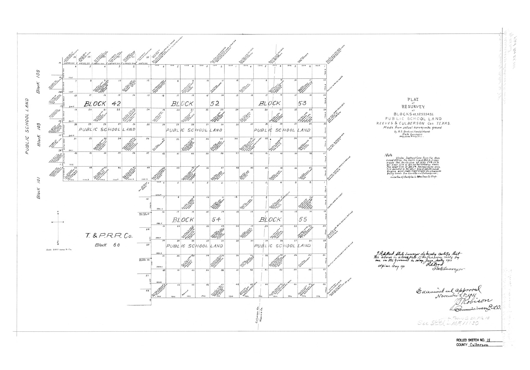
Culberson County Rolled Sketch 18
Plat of resurvey of Blocks 42, 52, 53, 54, 55 Public School Land, Reeves & Culberson Cos., Texas made from actual survey on the ground
-
Map/Doc
5650
-
Collection
General Map Collection
-
Object Dates
8/1911 (Creation Date)
11/25/1911 (File Date)
-
People and Organizations
Harold Marsh (Surveyor/Engineer)
R.S. Dod (Surveyor/Engineer)
-
Counties
Culberson Reeves
-
Subjects
Surveying Rolled Sketch
-
Height x Width
24.1 x 34.5 inches
61.2 x 87.6 cm
-
Scale
1" = 2000 varas
Part of: General Map Collection
Brooks County Rolled Sketch 18

Print $20.00
- Digital $50.00
Brooks County Rolled Sketch 18
Size 11.3 x 16.1 inches
Map/Doc 61786
Tom Green County Rolled Sketch 48

Print $20.00
- Digital $50.00
Tom Green County Rolled Sketch 48
1884
Size 14.3 x 22.7 inches
Map/Doc 8009
Lamar County State Real Property Sketch 1

Print $20.00
- Digital $50.00
Lamar County State Real Property Sketch 1
2013
Size 24.0 x 36.0 inches
Map/Doc 93658
Polk County Working Sketch 28

Print $40.00
- Digital $50.00
Polk County Working Sketch 28
1960
Size 53.5 x 43.6 inches
Map/Doc 71644
Atascosa County Rolled Sketch 10

Print $40.00
- Digital $50.00
Atascosa County Rolled Sketch 10
1943
Size 36.0 x 77.6 inches
Map/Doc 8428
Map of Brazoria

Print $20.00
- Digital $50.00
Map of Brazoria
1860
Size 19.8 x 26.7 inches
Map/Doc 856
Bosque County Working Sketch Graphic Index

Print $20.00
- Digital $50.00
Bosque County Working Sketch Graphic Index
1945
Size 46.9 x 36.5 inches
Map/Doc 76469
Nacogdoches County Boundary File 1a

Print $20.00
- Digital $50.00
Nacogdoches County Boundary File 1a
Size 4.7 x 30.5 inches
Map/Doc 57581
Americæ Nova Tabula

Print $20.00
- Digital $50.00
Americæ Nova Tabula
1633
Size 15.3 x 18.7 inches
Map/Doc 95827
Calhoun County Working Sketch 4

Print $20.00
- Digital $50.00
Calhoun County Working Sketch 4
1926
Size 29.2 x 42.2 inches
Map/Doc 67820
Crockett County Working Sketch 65

Print $20.00
- Digital $50.00
Crockett County Working Sketch 65
1957
Size 32.3 x 38.0 inches
Map/Doc 68398
Johnson County Boundary File 2a

Print $22.00
- Digital $50.00
Johnson County Boundary File 2a
Size 9.0 x 8.3 inches
Map/Doc 55566
You may also like
A. H. Baer Estate

Print $20.00
- Digital $50.00
A. H. Baer Estate
Size 18.4 x 15.6 inches
Map/Doc 92748
Flight Mission No. CRK-3P, Frame 175, Refugio County

Print $20.00
- Digital $50.00
Flight Mission No. CRK-3P, Frame 175, Refugio County
1956
Size 18.6 x 21.7 inches
Map/Doc 86922
Andrews County Working Sketch 33

Print $20.00
- Digital $50.00
Andrews County Working Sketch 33
1990
Size 32.9 x 29.7 inches
Map/Doc 67079
Cameron County Rolled Sketch 13

Print $40.00
- Digital $50.00
Cameron County Rolled Sketch 13
1952
Size 39.2 x 62.1 inches
Map/Doc 8567
[Surveys in Austin County]
![35, [Surveys in Austin County], General Map Collection](https://historictexasmaps.com/wmedia_w700/maps/35.tif.jpg)
Print $20.00
- Digital $50.00
[Surveys in Austin County]
1840
Size 20.8 x 28.2 inches
Map/Doc 35
La Salle County Boundary File 57a

Print $6.00
- Digital $50.00
La Salle County Boundary File 57a
Size 14.3 x 8.8 inches
Map/Doc 56255
Presidio County Working Sketch 60

Print $20.00
- Digital $50.00
Presidio County Working Sketch 60
1957
Size 21.9 x 18.4 inches
Map/Doc 71737
Denton County Sketch File 12

Print $4.00
- Digital $50.00
Denton County Sketch File 12
1856
Size 8.3 x 10.3 inches
Map/Doc 20711
Galveston County Rolled Sketch 46A

Print $20.00
- Digital $50.00
Galveston County Rolled Sketch 46A
2000
Size 24.9 x 37.6 inches
Map/Doc 5982
Flight Mission No. BRA-7M, Frame 30, Jefferson County

Print $20.00
- Digital $50.00
Flight Mission No. BRA-7M, Frame 30, Jefferson County
1953
Size 18.6 x 22.3 inches
Map/Doc 85481
Flight Mission No. DQN-5K, Frame 27, Calhoun County

Print $20.00
- Digital $50.00
Flight Mission No. DQN-5K, Frame 27, Calhoun County
1953
Size 18.4 x 22.1 inches
Map/Doc 84378
Fannin County Boundary File 10a and 10b and 10c

Print $4.00
- Digital $50.00
Fannin County Boundary File 10a and 10b and 10c
Size 11.3 x 8.8 inches
Map/Doc 53325