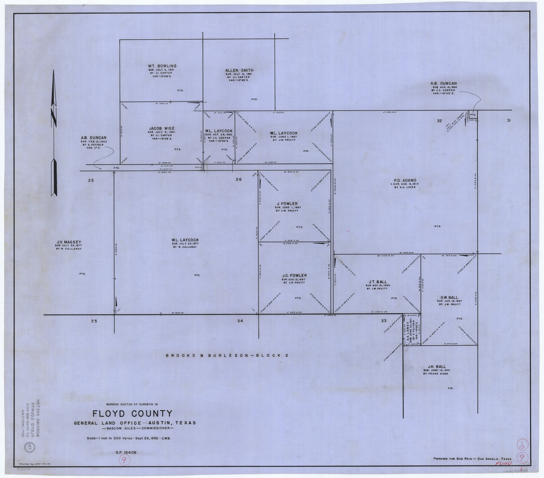
Floyd County Working Sketch 9
-
Map/Doc
69188
-
Collection
General Map Collection
-
Object Dates
9/26/1952 (Creation Date)
-
Counties
Floyd
-
Subjects
Surveying Working Sketch
-
Height x Width
31.5 x 35.9 inches
80.0 x 91.2 cm
-
Scale
1" = 200 varas
Part of: General Map Collection
Liberty County Rolled Sketch T

Print $20.00
- Digital $50.00
Liberty County Rolled Sketch T
1941
Size 20.8 x 16.0 inches
Map/Doc 6626
Johnson County Rolled Sketch B

Print $20.00
- Digital $50.00
Johnson County Rolled Sketch B
1891
Size 28.2 x 38.9 inches
Map/Doc 6449
San Patricio County Sketch File 3

Print $10.00
- Digital $50.00
San Patricio County Sketch File 3
1850
Size 11.0 x 15.6 inches
Map/Doc 36029

Map of Washburn, Armstrong County, Texas junction of Pan-Handle (Southern Kansas) and Fort Worth & Denver City R'ys

Print $20.00
- Digital $50.00
Map of Washburn, Armstrong County, Texas junction of Pan-Handle (Southern Kansas) and Fort Worth & Denver City R'ys
1888
Map/Doc 97426
Flight Mission No. DQO-2K, Frame 94, Galveston County

Print $20.00
- Digital $50.00
Flight Mission No. DQO-2K, Frame 94, Galveston County
1952
Size 18.7 x 22.4 inches
Map/Doc 85021
Hutchinson County Rolled Sketch 38

Print $40.00
- Digital $50.00
Hutchinson County Rolled Sketch 38
1955
Size 43.6 x 67.7 inches
Map/Doc 9248
Map of the River Sabine from its mouth on the Gulf of Mexico in the sea to Logan's Ferry in latitude 31° 58' 24" north

Print $20.00
- Digital $50.00
Map of the River Sabine from its mouth on the Gulf of Mexico in the sea to Logan's Ferry in latitude 31° 58' 24" north
1842
Size 18.5 x 9.0 inches
Map/Doc 65384
Edwards County Working Sketch 40

Print $20.00
- Digital $50.00
Edwards County Working Sketch 40
1949
Size 19.8 x 18.6 inches
Map/Doc 68916
Edwards County Working Sketch 54

Print $20.00
- Digital $50.00
Edwards County Working Sketch 54
1951
Size 19.2 x 28.5 inches
Map/Doc 68930
Flight Mission No. CRC-5R, Frame 19, Chambers County

Print $20.00
- Digital $50.00
Flight Mission No. CRC-5R, Frame 19, Chambers County
1956
Size 18.8 x 22.4 inches
Map/Doc 84941
San Augustine County Working Sketch 28

Print $20.00
- Digital $50.00
San Augustine County Working Sketch 28
2011
Size 23.4 x 36.7 inches
Map/Doc 90091
You may also like
[Galveston, Harrisburg & San Antonio Railroad from Cuero to Stockdale]
![64191, [Galveston, Harrisburg & San Antonio Railroad from Cuero to Stockdale], General Map Collection](https://historictexasmaps.com/wmedia_w700/maps/64191.tif.jpg)
Print $20.00
- Digital $50.00
[Galveston, Harrisburg & San Antonio Railroad from Cuero to Stockdale]
1907
Size 14.2 x 34.2 inches
Map/Doc 64191
Santa Rosa, the Saint of Roses - Lower Rio Grande Valley

Santa Rosa, the Saint of Roses - Lower Rio Grande Valley
1920
Map/Doc 96734
Flight Mission No. CRC-3R, Frame 204, Chambers County

Print $20.00
- Digital $50.00
Flight Mission No. CRC-3R, Frame 204, Chambers County
1956
Size 18.6 x 22.4 inches
Map/Doc 84859
Hutchinson County Rolled Sketch 44-3

Print $20.00
- Digital $50.00
Hutchinson County Rolled Sketch 44-3
2002
Size 24.0 x 36.0 inches
Map/Doc 77539
Pecos County Rolled Sketch 166

Print $22.00
- Digital $50.00
Pecos County Rolled Sketch 166
Size 32.5 x 37.6 inches
Map/Doc 9747
Swisher Co. Texas

Print $20.00
- Digital $50.00
Swisher Co. Texas
1936
Size 36.8 x 38.0 inches
Map/Doc 89876
Hardin County Rolled Sketch 11

Print $20.00
- Digital $50.00
Hardin County Rolled Sketch 11
1948
Size 20.8 x 38.6 inches
Map/Doc 6083
[Surveying sketch of Dan'l. Dunham, O. de Santangelo, et al in Zavala County]
![708, [Surveying sketch of Dan'l. Dunham, O. de Santangelo, et al in Zavala County], Maddox Collection](https://historictexasmaps.com/wmedia_w700/maps/0708.tif.jpg)
Print $20.00
- Digital $50.00
[Surveying sketch of Dan'l. Dunham, O. de Santangelo, et al in Zavala County]
Size 16.2 x 16.0 inches
Map/Doc 708
El Paso County Sketch File 14

Print $20.00
- Digital $50.00
El Paso County Sketch File 14
1922
Size 24.0 x 17.2 inches
Map/Doc 11452
Dickens County

Print $20.00
- Digital $50.00
Dickens County
1877
Size 19.1 x 18.4 inches
Map/Doc 3486

Calhoun County Sketch File 14

Print $20.00
- Digital $50.00
Calhoun County Sketch File 14
1852
Size 22.6 x 16.2 inches
Map/Doc 35980