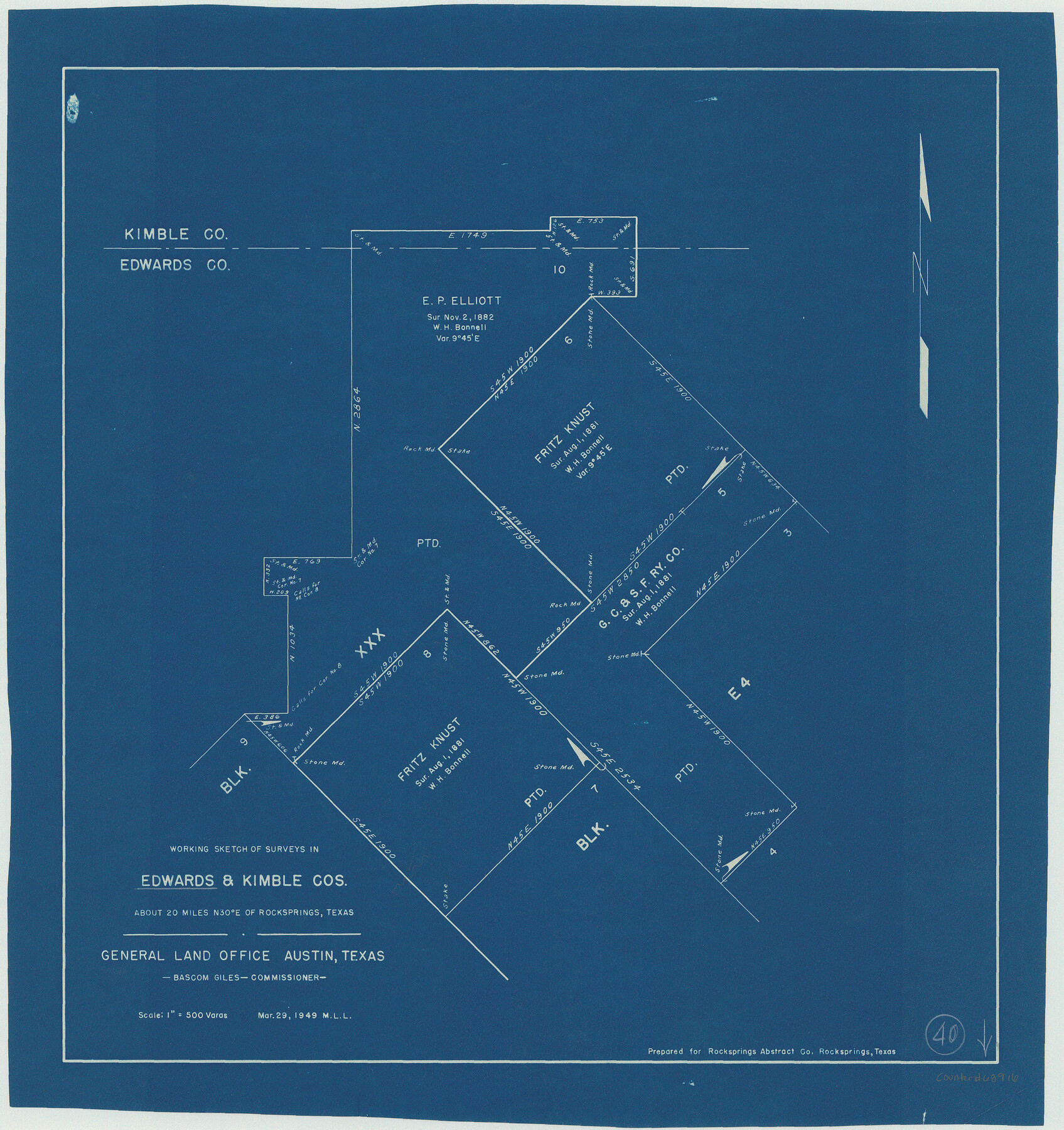
Edwards County Working Sketch 40
-
Map/Doc
68916
-
Collection
General Map Collection
-
Object Dates
3/29/1949 (Creation Date)
-
People and Organizations
M. L. Liles (Draftsman)
-
Counties
Edwards Kimble
-
Subjects
Surveying Working Sketch
-
Height x Width
19.8 x 18.6 inches
50.3 x 47.2 cm
-
Scale
1" = 500 varas
Part of: General Map Collection
Flight Mission No. CRC-6R, Frame 10, Chambers County

Print $20.00
- Digital $50.00
Flight Mission No. CRC-6R, Frame 10, Chambers County
1956
Size 18.6 x 22.4 inches
Map/Doc 84964
San Jacinto County Rolled Sketch 12

Print $20.00
- Digital $50.00
San Jacinto County Rolled Sketch 12
1948
Size 24.2 x 32.5 inches
Map/Doc 7561
Williamson County

Print $20.00
- Digital $50.00
Williamson County
1872
Size 18.4 x 28.2 inches
Map/Doc 4151
Matagorda County Sketch File 5

Print $4.00
- Digital $50.00
Matagorda County Sketch File 5
Size 10.0 x 8.0 inches
Map/Doc 30736

Angelina County Sketch File 29

Print $4.00
- Digital $50.00
Angelina County Sketch File 29
1911
Size 8.0 x 8.4 inches
Map/Doc 13087
Jefferson County Rolled Sketch 35

Print $20.00
- Digital $50.00
Jefferson County Rolled Sketch 35
1957
Size 37.9 x 26.0 inches
Map/Doc 6394
Kinney County Rolled Sketch 9

Print $20.00
- Digital $50.00
Kinney County Rolled Sketch 9
Size 39.4 x 27.5 inches
Map/Doc 6538
Brewster County Rolled Sketch 128

Print $20.00
- Digital $50.00
Brewster County Rolled Sketch 128
1978
Size 24.9 x 28.0 inches
Map/Doc 5300
Leon County Rolled Sketch 4

Print $20.00
- Digital $50.00
Leon County Rolled Sketch 4
1947
Size 34.6 x 35.4 inches
Map/Doc 9426
United States - Gulf Coast - From Latitude 26° 33' to the Rio Grande Texas

Print $20.00
- Digital $50.00
United States - Gulf Coast - From Latitude 26° 33' to the Rio Grande Texas
1913
Size 27.8 x 18.4 inches
Map/Doc 72831
Padre Island National Seashore

Print $4.00
- Digital $50.00
Padre Island National Seashore
Size 16.0 x 22.1 inches
Map/Doc 60528
You may also like
Orange County Sketch File 37

Print $8.00
- Digital $50.00
Orange County Sketch File 37
1950
Size 14.2 x 8.8 inches
Map/Doc 33374
Trinity River, Levee Improvement Districts, Widths of Floodways

Print $4.00
- Digital $50.00
Trinity River, Levee Improvement Districts, Widths of Floodways
1919
Size 23.5 x 17.6 inches
Map/Doc 65250
University of Texas System University Lands

Print $20.00
- Digital $50.00
University of Texas System University Lands
Size 23.1 x 17.5 inches
Map/Doc 93238
Brewster County Rolled Sketch 60

Print $20.00
- Digital $50.00
Brewster County Rolled Sketch 60
Size 24.8 x 36.5 inches
Map/Doc 61783
Clay County Sketch File 26

Print $84.00
- Digital $50.00
Clay County Sketch File 26
1888
Size 14.3 x 9.0 inches
Map/Doc 18442
Flight Mission No. DAG-21K, Frame 41, Matagorda County

Print $20.00
- Digital $50.00
Flight Mission No. DAG-21K, Frame 41, Matagorda County
1952
Size 18.6 x 19.3 inches
Map/Doc 86408
Flight Mission No. CRC-4R, Frame 161, Chambers County

Print $20.00
- Digital $50.00
Flight Mission No. CRC-4R, Frame 161, Chambers County
1956
Size 18.5 x 22.3 inches
Map/Doc 84920
Crane County Sketch File 12

Print $6.00
- Digital $50.00
Crane County Sketch File 12
1901
Size 16.4 x 8.6 inches
Map/Doc 19571
The Mexican Municipality of Mina. Created, April 1834

Print $20.00
The Mexican Municipality of Mina. Created, April 1834
2020
Size 10.7 x 21.7 inches
Map/Doc 96028
Culberson County Working Sketch 49

Print $40.00
- Digital $50.00
Culberson County Working Sketch 49
1972
Size 49.2 x 37.6 inches
Map/Doc 68503
Gulf of Mexico

Print $20.00
- Digital $50.00
Gulf of Mexico
1908
Size 18.3 x 28.0 inches
Map/Doc 72661
Collingsworth County Sketch File 9

Print $20.00
- Digital $50.00
Collingsworth County Sketch File 9
Size 16.5 x 12.0 inches
Map/Doc 11133