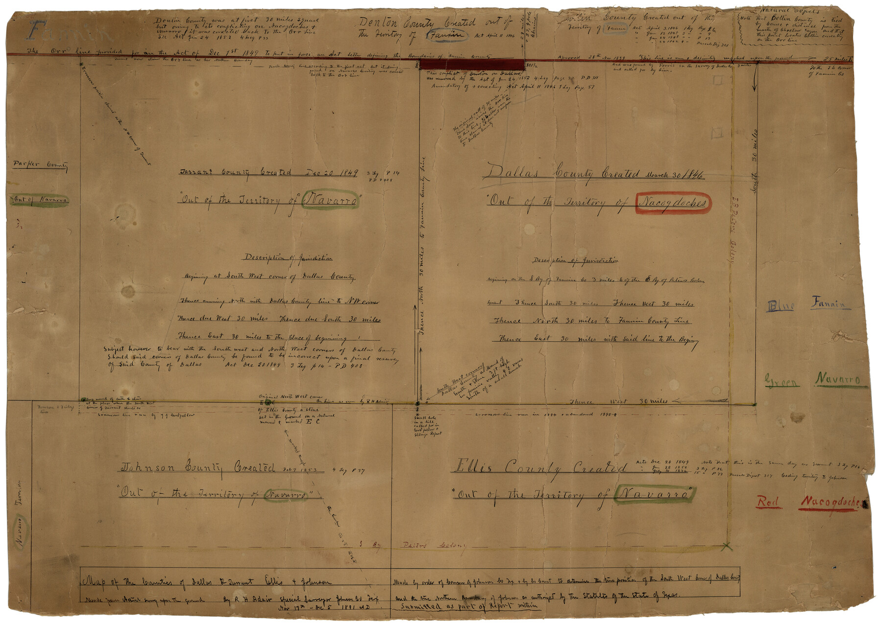
Johnson County Rolled Sketch B
Map of the Counties of Dallas & Tarrant, Ellis & Johnson
-
Map/Doc
6449
-
Collection
General Map Collection
-
Object Dates
12/5/1891 (Creation Date)
-
People and Organizations
R.H. Adair (Surveyor/Engineer)
-
Counties
Johnson Ellis Tarrant Dallas
-
Subjects
Surveying Rolled Sketch
-
Height x Width
28.2 x 38.9 inches
71.6 x 98.8 cm
-
Medium
paper, manuscript
-
Comments
See Johnson County Sketch File 26 (28474) for report.
Related maps
Johnson County Sketch File 26

Print $28.00
- Digital $50.00
Johnson County Sketch File 26
1892
Size 14.3 x 8.8 inches
Map/Doc 28474
Part of: General Map Collection
Galveston County Rolled Sketch 32

Print $20.00
- Digital $50.00
Galveston County Rolled Sketch 32
1979
Size 44.3 x 31.0 inches
Map/Doc 9015
Alamo Defenders Heritage Map of Texas

Print $20.00
Alamo Defenders Heritage Map of Texas
2025
Size 36.0 x 24.0 inches
Map/Doc 97433
Flight Mission No. CRC-3R, Frame 19, Chambers County

Print $20.00
- Digital $50.00
Flight Mission No. CRC-3R, Frame 19, Chambers County
1956
Size 18.5 x 22.1 inches
Map/Doc 84793
Houston County

Print $20.00
- Digital $50.00
Houston County
1888
Size 24.5 x 26.1 inches
Map/Doc 3683
Cherokee County Working Sketch 8

Print $20.00
- Digital $50.00
Cherokee County Working Sketch 8
1956
Size 22.0 x 45.2 inches
Map/Doc 67963
Wise County Sketch File 13

Print $4.00
- Digital $50.00
Wise County Sketch File 13
Size 9.0 x 15.2 inches
Map/Doc 40546
Foard County Sketch File X

Print $20.00
- Digital $50.00
Foard County Sketch File X
1882
Size 15.8 x 17.3 inches
Map/Doc 11499
Randall County Rolled Sketch 2

Print $20.00
- Digital $50.00
Randall County Rolled Sketch 2
1941
Size 31.9 x 23.9 inches
Map/Doc 7422
Stephens County Working Sketch 39

Print $20.00
- Digital $50.00
Stephens County Working Sketch 39
1995
Size 25.5 x 27.1 inches
Map/Doc 63982
Matagorda County Sketch File 39

Print $20.00
- Digital $50.00
Matagorda County Sketch File 39
Size 31.1 x 24.3 inches
Map/Doc 12047
Hutchinson County Working Sketch Graphic Index - sheet 2

Print $20.00
- Digital $50.00
Hutchinson County Working Sketch Graphic Index - sheet 2
1922
Size 43.8 x 36.7 inches
Map/Doc 76587
Central & Montgomery

Print $40.00
- Digital $50.00
Central & Montgomery
1941
Size 25.6 x 122.2 inches
Map/Doc 64522
You may also like
Brazoria County Sketch File 12a

Print $4.00
- Digital $50.00
Brazoria County Sketch File 12a
1886
Size 11.2 x 8.5 inches
Map/Doc 14971
Kimble County Working Sketch 12

Print $20.00
- Digital $50.00
Kimble County Working Sketch 12
1922
Size 27.6 x 19.5 inches
Map/Doc 70080
[Surveys in Austin's Colony along the Yegua River and Cedar Creek]
![67, [Surveys in Austin's Colony along the Yegua River and Cedar Creek], General Map Collection](https://historictexasmaps.com/wmedia_w700/maps/67.tif.jpg)
Print $20.00
- Digital $50.00
[Surveys in Austin's Colony along the Yegua River and Cedar Creek]
1835
Size 15.7 x 19.3 inches
Map/Doc 67
Montgomery County Rolled Sketch 15

Print $40.00
- Digital $50.00
Montgomery County Rolled Sketch 15
1932
Size 23.7 x 49.0 inches
Map/Doc 9527
Austin County Sketch File 11

Print $8.00
- Digital $50.00
Austin County Sketch File 11
1895
Size 11.1 x 8.6 inches
Map/Doc 13877
Terrell County Working Sketch 84d

Print $20.00
- Digital $50.00
Terrell County Working Sketch 84d
1992
Size 18.4 x 31.5 inches
Map/Doc 69608
McMullen County Sketch File 16

Print $24.00
- Digital $50.00
McMullen County Sketch File 16
1876
Size 5.3 x 8.3 inches
Map/Doc 31365
[Surveys along Seco, Pecan and Deer Creeks]
![316, [Surveys along Seco, Pecan and Deer Creeks], General Map Collection](https://historictexasmaps.com/wmedia_w700/maps/316.tif.jpg)
Print $2.00
- Digital $50.00
[Surveys along Seco, Pecan and Deer Creeks]
1847
Size 8.9 x 7.8 inches
Map/Doc 316
United States - Gulf Coast Texas - Northern part of Laguna Madre

Print $20.00
- Digital $50.00
United States - Gulf Coast Texas - Northern part of Laguna Madre
1923
Size 26.7 x 18.2 inches
Map/Doc 72930
Uvalde County Working Sketch 27

Print $20.00
- Digital $50.00
Uvalde County Working Sketch 27
1957
Size 24.4 x 25.7 inches
Map/Doc 72097
[Blocks GP and T]
![91509, [Blocks GP and T], Twichell Survey Records](https://historictexasmaps.com/wmedia_w700/maps/91509-1.tif.jpg)
Print $20.00
- Digital $50.00
[Blocks GP and T]
Size 26.0 x 24.6 inches
Map/Doc 91509
Childress Co.

Print $20.00
- Digital $50.00
Childress Co.
1892
Size 40.3 x 33.7 inches
Map/Doc 66752