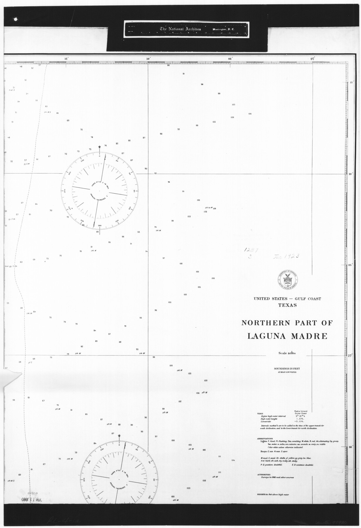
United States - Gulf Coast Texas - Northern part of Laguna Madre
RL-4-1a
-
Map/Doc
72930
-
Collection
General Map Collection
-
Object Dates
1923 (Creation Date)
-
People and Organizations
U. S. Coast and Geodetic Survey (Publisher)
U. S. Coast and Geodetic Survey (Author)
-
Subjects
Nautical Charts
-
Height x Width
26.7 x 18.2 inches
67.8 x 46.2 cm
-
Comments
B/W photostat copy from National Archives in multiple pieces.
Part of: General Map Collection
Ellis County Working Sketch 5

Print $40.00
- Digital $50.00
Ellis County Working Sketch 5
1997
Size 49.2 x 32.4 inches
Map/Doc 69021
The Land of Open Sky - Southwest U.S.A.

The Land of Open Sky - Southwest U.S.A.
Size 20.2 x 15.6 inches
Map/Doc 95945
Polk County Sketch File 21

Print $8.00
- Digital $50.00
Polk County Sketch File 21
Size 12.9 x 8.3 inches
Map/Doc 34169
Dickens County Rolled Sketch P1

Print $20.00
- Digital $50.00
Dickens County Rolled Sketch P1
1915
Size 40.5 x 36.2 inches
Map/Doc 8783
Val Verde County Working Sketch 9

Print $20.00
- Digital $50.00
Val Verde County Working Sketch 9
1917
Size 19.4 x 30.9 inches
Map/Doc 72144
Bexar County Rolled Sketch 16
Print $20.00
- Digital $50.00
Bexar County Rolled Sketch 16
1847
Size 21.1 x 14.8 inches
Map/Doc 5141
Aransas County Boundary File 3

Print $16.00
- Digital $50.00
Aransas County Boundary File 3
Size 10.6 x 8.0 inches
Map/Doc 49782
Motley County

Print $20.00
- Digital $50.00
Motley County
1966
Size 43.8 x 34.8 inches
Map/Doc 73247
Midland County Working Sketch 33

Print $20.00
- Digital $50.00
Midland County Working Sketch 33
1982
Size 38.2 x 36.2 inches
Map/Doc 71014
Floyd County Sketch File 18

Print $32.00
- Digital $50.00
Floyd County Sketch File 18
1913
Size 13.4 x 9.0 inches
Map/Doc 22753
La Salle County Sketch File 22

Print $4.00
- Digital $50.00
La Salle County Sketch File 22
1875
Size 12.8 x 8.2 inches
Map/Doc 29528
Hidalgo County Working Sketch 8

Print $40.00
- Digital $50.00
Hidalgo County Working Sketch 8
1963
Size 25.7 x 72.8 inches
Map/Doc 66185
You may also like
Shelby County Working Sketch 29

Print $20.00
- Digital $50.00
Shelby County Working Sketch 29
2000
Size 19.6 x 29.9 inches
Map/Doc 63883
Brewster County Rolled Sketch 88

Print $20.00
- Digital $50.00
Brewster County Rolled Sketch 88
1948
Size 23.7 x 19.7 inches
Map/Doc 5248
Floyd County Working Sketch 4

Print $20.00
- Digital $50.00
Floyd County Working Sketch 4
1952
Size 23.2 x 29.0 inches
Map/Doc 69183
Sabine Pass and Lake

Print $20.00
- Digital $50.00
Sabine Pass and Lake
1958
Size 47.1 x 27.5 inches
Map/Doc 69823
Fayette County Working Sketch 5

Print $20.00
- Digital $50.00
Fayette County Working Sketch 5
1981
Size 16.2 x 14.6 inches
Map/Doc 69169
Gillespie County

Print $20.00
- Digital $50.00
Gillespie County
1945
Size 36.7 x 45.6 inches
Map/Doc 77289
Map of Hopkins County

Print $20.00
- Digital $50.00
Map of Hopkins County
1872
Size 17.8 x 18.4 inches
Map/Doc 4566
San Patricio County, Texas

Print $20.00
- Digital $50.00
San Patricio County, Texas
1879
Size 18.1 x 22.8 inches
Map/Doc 611
Crockett County Sketch File 64

Print $20.00
- Digital $50.00
Crockett County Sketch File 64
1927
Size 17.0 x 21.3 inches
Map/Doc 11229

Galveston County Sketch File 46

Print $20.00
- Digital $50.00
Galveston County Sketch File 46
1912
Size 14.0 x 34.1 inches
Map/Doc 11541
Map of Survey 9, Block 1, D.B. Gardner

Print $20.00
- Digital $50.00
Map of Survey 9, Block 1, D.B. Gardner
1915
Size 14.0 x 19.0 inches
Map/Doc 415