Hydrography of Sabine Pass and Lake, La. And Tex.

Print $40.00
- Digital $50.00
Hydrography of Sabine Pass and Lake, La. And Tex.
1885
Size: 53.2 x 32.5 inches
2085
Navigation District Property Map, Port of Houston, Harris County Houston Ship Channel Navigation District, Houston, Texas

Print $40.00
- Digital $50.00
Navigation District Property Map, Port of Houston, Harris County Houston Ship Channel Navigation District, Houston, Texas
1955
Size: 26.9 x 68.7 inches
2103
Hydrographic Survey H-1288B Corpus Christi Pass

Print $40.00
- Digital $50.00
Hydrographic Survey H-1288B Corpus Christi Pass
1875
Size: 31.0 x 52.6 inches
2691
Hydrographic Survey H-1288B Corpus Christi Pass

Print $40.00
- Digital $50.00
Hydrographic Survey H-1288B Corpus Christi Pass
1875
Size: 31.8 x 52.5 inches
2692
Corpus Christi Pass

Print $20.00
- Digital $50.00
Corpus Christi Pass
1880
Size: 45.5 x 41.0 inches
2694
Hydography Survey H-1465 Corpus Christi Pass

Print $20.00
- Digital $50.00
Hydography Survey H-1465 Corpus Christi Pass
1880
Size: 45.0 x 40.9 inches
2695
Hydrography Survey H-6395 Off Coast of Texas, Aransas Pass to Corpus Christi Pass in the Gulf of Mexico

Print $40.00
- Digital $50.00
Hydrography Survey H-6395 Off Coast of Texas, Aransas Pass to Corpus Christi Pass in the Gulf of Mexico
1938
Size: 56.1 x 33.6 inches
2696
Hydrographic Survey H-6395 of Outer Coast of Padre Island; Gulf of Mexico

Print $40.00
- Digital $50.00
Hydrographic Survey H-6395 of Outer Coast of Padre Island; Gulf of Mexico
1938
Size: 55.1 x 33.3 inches
2697
Hydrographic Survey H-6396 of Outer Coast of Padre Island; Gulf of Mexico

Print $40.00
- Digital $50.00
Hydrographic Survey H-6396 of Outer Coast of Padre Island; Gulf of Mexico
1938
Size: 55.4 x 34.0 inches
2698
Hydrographic Survey H-6396 of Outer Coast of Padre Island; Gulf of Mexico

Print $40.00
- Digital $50.00
Hydrographic Survey H-6396 of Outer Coast of Padre Island; Gulf of Mexico
1938
Size: 54.4 x 33.5 inches
2699
Hydograhic Survey H-994, Corpus Christi Pass

Print $40.00
- Digital $50.00
Hydograhic Survey H-994, Corpus Christi Pass
1869
Size: 32.1 x 53.5 inches
2700
Hydograhic Survey H-994, Corpus Christi Pass

Print $40.00
- Digital $50.00
Hydograhic Survey H-994, Corpus Christi Pass
1869
Size: 31.8 x 53.7 inches
2701
Proposed bombing and machine gun restricted areas along Gulf of Mexico from San Luis Pass to Aransas Pass

Print $20.00
- Digital $50.00
Proposed bombing and machine gun restricted areas along Gulf of Mexico from San Luis Pass to Aransas Pass
1941
Size: 11.1 x 24.1 inches
3024
Survey Gulf to Beaumont and Orange, Texas

Print $20.00
- Digital $50.00
Survey Gulf to Beaumont and Orange, Texas
1929
Size: 29.3 x 41.7 inches
3089
Topography and water depth as shown by the U.S. Coast Survey of 1888

Print $20.00
- Digital $50.00
Topography and water depth as shown by the U.S. Coast Survey of 1888
1890
Size: 17.0 x 18.8 inches
390
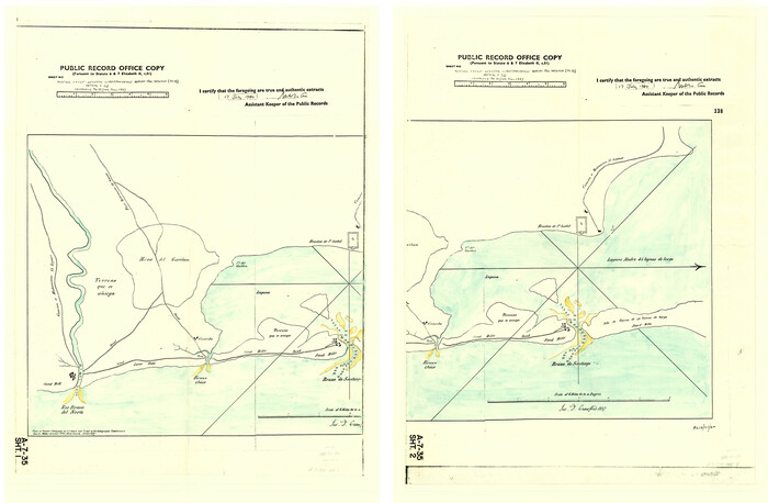
[Old Coastal Chart showing Brazo Chico, Brazo de Santiago and Rio Bravo del Norte passes with depth readings]
Print $20.00
- Digital $50.00
[Old Coastal Chart showing Brazo Chico, Brazo de Santiago and Rio Bravo del Norte passes with depth readings]
1837
Size: 25.7 x 39.3 inches
4661
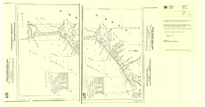
[Old Coastal Chart of Texas Coast showing passes with depth readings]
Print $40.00
- Digital $50.00
[Old Coastal Chart of Texas Coast showing passes with depth readings]
Size: 25.4 x 48.6 inches
4662
Map of the Houston Ship Channel showing all industries, railways, public and private docks, and approximate all original surveys in the vicinity of the channel

Print $20.00
- Digital $50.00
Map of the Houston Ship Channel showing all industries, railways, public and private docks, and approximate all original surveys in the vicinity of the channel
1925
Size: 14.5 x 30.2 inches
4666
Topography and Water Depth as Shown by the US Coast Survey of 1888

Print $20.00
- Digital $50.00
Topography and Water Depth as Shown by the US Coast Survey of 1888
1890
Size: 16.9 x 18.9 inches
5036
Port Aransas-Corpus Christi Waterway, Texas, Avery Point Turning Basin to Vicinity of Tule Lake - Dredging

Print $20.00
- Digital $50.00
Port Aransas-Corpus Christi Waterway, Texas, Avery Point Turning Basin to Vicinity of Tule Lake - Dredging
1947
Size: 28.5 x 41.4 inches
60301
Port Aransas-Corpus Christi Waterway, Texas, Avery Point Turning Basin to Vicinity of Tule Lake - Dredging

Print $20.00
- Digital $50.00
Port Aransas-Corpus Christi Waterway, Texas, Avery Point Turning Basin to Vicinity of Tule Lake - Dredging
1947
Size: 28.4 x 41.4 inches
60302
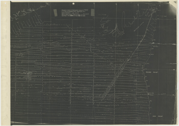
[Photostats of section of Hydrographic Surveys H-5399, H-4822 and H-470, Mouth of Trinity River]
Print $20.00
- Digital $50.00
[Photostats of section of Hydrographic Surveys H-5399, H-4822 and H-470, Mouth of Trinity River]
1933
Size: 18.2 x 25.8 inches
61154
Photostat of section of hydrographic surveys H-5399, H-4822, H-470

Print $2.00
- Digital $50.00
Photostat of section of hydrographic surveys H-5399, H-4822, H-470
1933
Size: 10.6 x 8.1 inches
61155
Photostat of section of hydrographic surveys H-5399, H-4822, H-470

Print $20.00
- Digital $50.00
Photostat of section of hydrographic surveys H-5399, H-4822, H-470
1933
Size: 18.3 x 25.8 inches
61156
Photostat of section of hydrographic surveys H-5399, H-4822, H-470

Print $2.00
- Digital $50.00
Photostat of section of hydrographic surveys H-5399, H-4822, H-470
1933
Size: 10.8 x 8.1 inches
61157
Photostat of section of hydrographic surveys H-5399, H-4822, H-470

Print $20.00
- Digital $50.00
Photostat of section of hydrographic surveys H-5399, H-4822, H-470
1933
Size: 25.9 x 18.3 inches
61158
Photostat of section of hydrographic surveys H-5399, H-4822, H-470

Print $2.00
- Digital $50.00
Photostat of section of hydrographic surveys H-5399, H-4822, H-470
1933
Size: 10.6 x 8.1 inches
61159
Photostat of section of hydrographic surveys H-5399, H-4822, H-470

Print $20.00
- Digital $50.00
Photostat of section of hydrographic surveys H-5399, H-4822, H-470
1933
Size: 18.4 x 25.8 inches
61160
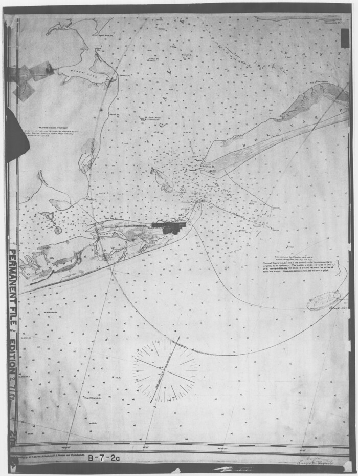
[Coastal Chart of Galveston Island, Bolivar Peninsula and Galveston Bay]
Print $20.00
- Digital $50.00
[Coastal Chart of Galveston Island, Bolivar Peninsula and Galveston Bay]
Size: 24.0 x 18.1 inches
61804
Nueces County Navigation District Number One, Submerged Lands Maintained for Navigational Purposes Persuant to Sub-Section G of Section 61.117 Texas Water Code

Print $20.00
- Digital $50.00
Nueces County Navigation District Number One, Submerged Lands Maintained for Navigational Purposes Persuant to Sub-Section G of Section 61.117 Texas Water Code
1975
Size: 23.3 x 29.9 inches
61806
Hydrography of Sabine Pass and Lake, La. And Tex.
Print $40.00
- Digital $50.00
Hydrography of Sabine Pass and Lake, La. And Tex.
1885
-
Size
53.2 x 32.5 inches
-
Map/Doc
2085
-
Creation Date
1885
Navigation District Property Map, Port of Houston, Harris County Houston Ship Channel Navigation District, Houston, Texas
Print $40.00
- Digital $50.00
Navigation District Property Map, Port of Houston, Harris County Houston Ship Channel Navigation District, Houston, Texas
1955
-
Size
26.9 x 68.7 inches
-
Map/Doc
2103
-
Creation Date
1955
Hydrographic Survey H-1288B Corpus Christi Pass
Print $40.00
- Digital $50.00
Hydrographic Survey H-1288B Corpus Christi Pass
1875
-
Size
31.0 x 52.6 inches
-
Map/Doc
2691
-
Creation Date
1875
Hydrographic Survey H-1288B Corpus Christi Pass
Print $40.00
- Digital $50.00
Hydrographic Survey H-1288B Corpus Christi Pass
1875
-
Size
31.8 x 52.5 inches
-
Map/Doc
2692
-
Creation Date
1875
Corpus Christi Pass
Print $20.00
- Digital $50.00
Corpus Christi Pass
1880
-
Size
45.5 x 41.0 inches
-
Map/Doc
2694
-
Creation Date
1880
Hydography Survey H-1465 Corpus Christi Pass
Print $20.00
- Digital $50.00
Hydography Survey H-1465 Corpus Christi Pass
1880
-
Size
45.0 x 40.9 inches
-
Map/Doc
2695
-
Creation Date
1880
Hydrography Survey H-6395 Off Coast of Texas, Aransas Pass to Corpus Christi Pass in the Gulf of Mexico
Print $40.00
- Digital $50.00
Hydrography Survey H-6395 Off Coast of Texas, Aransas Pass to Corpus Christi Pass in the Gulf of Mexico
1938
-
Size
56.1 x 33.6 inches
-
Map/Doc
2696
-
Creation Date
1938
Hydrographic Survey H-6395 of Outer Coast of Padre Island; Gulf of Mexico
Print $40.00
- Digital $50.00
Hydrographic Survey H-6395 of Outer Coast of Padre Island; Gulf of Mexico
1938
-
Size
55.1 x 33.3 inches
-
Map/Doc
2697
-
Creation Date
1938
Hydrographic Survey H-6396 of Outer Coast of Padre Island; Gulf of Mexico
Print $40.00
- Digital $50.00
Hydrographic Survey H-6396 of Outer Coast of Padre Island; Gulf of Mexico
1938
-
Size
55.4 x 34.0 inches
-
Map/Doc
2698
-
Creation Date
1938
Hydrographic Survey H-6396 of Outer Coast of Padre Island; Gulf of Mexico
Print $40.00
- Digital $50.00
Hydrographic Survey H-6396 of Outer Coast of Padre Island; Gulf of Mexico
1938
-
Size
54.4 x 33.5 inches
-
Map/Doc
2699
-
Creation Date
1938
Hydograhic Survey H-994, Corpus Christi Pass
Print $40.00
- Digital $50.00
Hydograhic Survey H-994, Corpus Christi Pass
1869
-
Size
32.1 x 53.5 inches
-
Map/Doc
2700
-
Creation Date
1869
Hydograhic Survey H-994, Corpus Christi Pass
Print $40.00
- Digital $50.00
Hydograhic Survey H-994, Corpus Christi Pass
1869
-
Size
31.8 x 53.7 inches
-
Map/Doc
2701
-
Creation Date
1869
Proposed bombing and machine gun restricted areas along Gulf of Mexico from San Luis Pass to Aransas Pass
Print $20.00
- Digital $50.00
Proposed bombing and machine gun restricted areas along Gulf of Mexico from San Luis Pass to Aransas Pass
1941
-
Size
11.1 x 24.1 inches
-
Map/Doc
3024
-
Creation Date
1941
Survey Gulf to Beaumont and Orange, Texas
Print $20.00
- Digital $50.00
Survey Gulf to Beaumont and Orange, Texas
1929
-
Size
29.3 x 41.7 inches
-
Map/Doc
3089
-
Creation Date
1929
Topography and water depth as shown by the U.S. Coast Survey of 1888
Print $20.00
- Digital $50.00
Topography and water depth as shown by the U.S. Coast Survey of 1888
1890
-
Size
17.0 x 18.8 inches
-
Map/Doc
390
-
Creation Date
1890
[Old Coastal Chart showing Brazo Chico, Brazo de Santiago and Rio Bravo del Norte passes with depth readings]
Print $20.00
- Digital $50.00
[Old Coastal Chart showing Brazo Chico, Brazo de Santiago and Rio Bravo del Norte passes with depth readings]
1837
-
Size
25.7 x 39.3 inches
-
Map/Doc
4661
-
Creation Date
1837
[Old Coastal Chart of Texas Coast showing passes with depth readings]
Print $40.00
- Digital $50.00
[Old Coastal Chart of Texas Coast showing passes with depth readings]
-
Size
25.4 x 48.6 inches
-
Map/Doc
4662
Map of the Houston Ship Channel showing all industries, railways, public and private docks, and approximate all original surveys in the vicinity of the channel
Print $20.00
- Digital $50.00
Map of the Houston Ship Channel showing all industries, railways, public and private docks, and approximate all original surveys in the vicinity of the channel
1925
-
Size
14.5 x 30.2 inches
-
Map/Doc
4666
-
Creation Date
1925
Topography and Water Depth as Shown by the US Coast Survey of 1888
Print $20.00
- Digital $50.00
Topography and Water Depth as Shown by the US Coast Survey of 1888
1890
-
Size
16.9 x 18.9 inches
-
Map/Doc
5036
-
Creation Date
1890
Port Aransas-Corpus Christi Waterway, Texas, Avery Point Turning Basin to Vicinity of Tule Lake - Dredging
Print $20.00
- Digital $50.00
Port Aransas-Corpus Christi Waterway, Texas, Avery Point Turning Basin to Vicinity of Tule Lake - Dredging
1947
-
Size
28.5 x 41.4 inches
-
Map/Doc
60301
-
Creation Date
1947
Port Aransas-Corpus Christi Waterway, Texas, Avery Point Turning Basin to Vicinity of Tule Lake - Dredging
Print $20.00
- Digital $50.00
Port Aransas-Corpus Christi Waterway, Texas, Avery Point Turning Basin to Vicinity of Tule Lake - Dredging
1947
-
Size
28.4 x 41.4 inches
-
Map/Doc
60302
-
Creation Date
1947
[Photostats of section of Hydrographic Surveys H-5399, H-4822 and H-470, Mouth of Trinity River]
Print $20.00
- Digital $50.00
[Photostats of section of Hydrographic Surveys H-5399, H-4822 and H-470, Mouth of Trinity River]
1933
-
Size
18.2 x 25.8 inches
-
Map/Doc
61154
-
Creation Date
1933
Photostat of section of hydrographic surveys H-5399, H-4822, H-470
Print $2.00
- Digital $50.00
Photostat of section of hydrographic surveys H-5399, H-4822, H-470
1933
-
Size
10.6 x 8.1 inches
-
Map/Doc
61155
-
Creation Date
1933
Photostat of section of hydrographic surveys H-5399, H-4822, H-470
Print $20.00
- Digital $50.00
Photostat of section of hydrographic surveys H-5399, H-4822, H-470
1933
-
Size
18.3 x 25.8 inches
-
Map/Doc
61156
-
Creation Date
1933
Photostat of section of hydrographic surveys H-5399, H-4822, H-470
Print $2.00
- Digital $50.00
Photostat of section of hydrographic surveys H-5399, H-4822, H-470
1933
-
Size
10.8 x 8.1 inches
-
Map/Doc
61157
-
Creation Date
1933
Photostat of section of hydrographic surveys H-5399, H-4822, H-470
Print $20.00
- Digital $50.00
Photostat of section of hydrographic surveys H-5399, H-4822, H-470
1933
-
Size
25.9 x 18.3 inches
-
Map/Doc
61158
-
Creation Date
1933
Photostat of section of hydrographic surveys H-5399, H-4822, H-470
Print $2.00
- Digital $50.00
Photostat of section of hydrographic surveys H-5399, H-4822, H-470
1933
-
Size
10.6 x 8.1 inches
-
Map/Doc
61159
-
Creation Date
1933
Photostat of section of hydrographic surveys H-5399, H-4822, H-470
Print $20.00
- Digital $50.00
Photostat of section of hydrographic surveys H-5399, H-4822, H-470
1933
-
Size
18.4 x 25.8 inches
-
Map/Doc
61160
-
Creation Date
1933
[Coastal Chart of Galveston Island, Bolivar Peninsula and Galveston Bay]
Print $20.00
- Digital $50.00
[Coastal Chart of Galveston Island, Bolivar Peninsula and Galveston Bay]
-
Size
24.0 x 18.1 inches
-
Map/Doc
61804
Nueces County Navigation District Number One, Submerged Lands Maintained for Navigational Purposes Persuant to Sub-Section G of Section 61.117 Texas Water Code
Print $20.00
- Digital $50.00
Nueces County Navigation District Number One, Submerged Lands Maintained for Navigational Purposes Persuant to Sub-Section G of Section 61.117 Texas Water Code
1975
-
Size
23.3 x 29.9 inches
-
Map/Doc
61806
-
Creation Date
1975