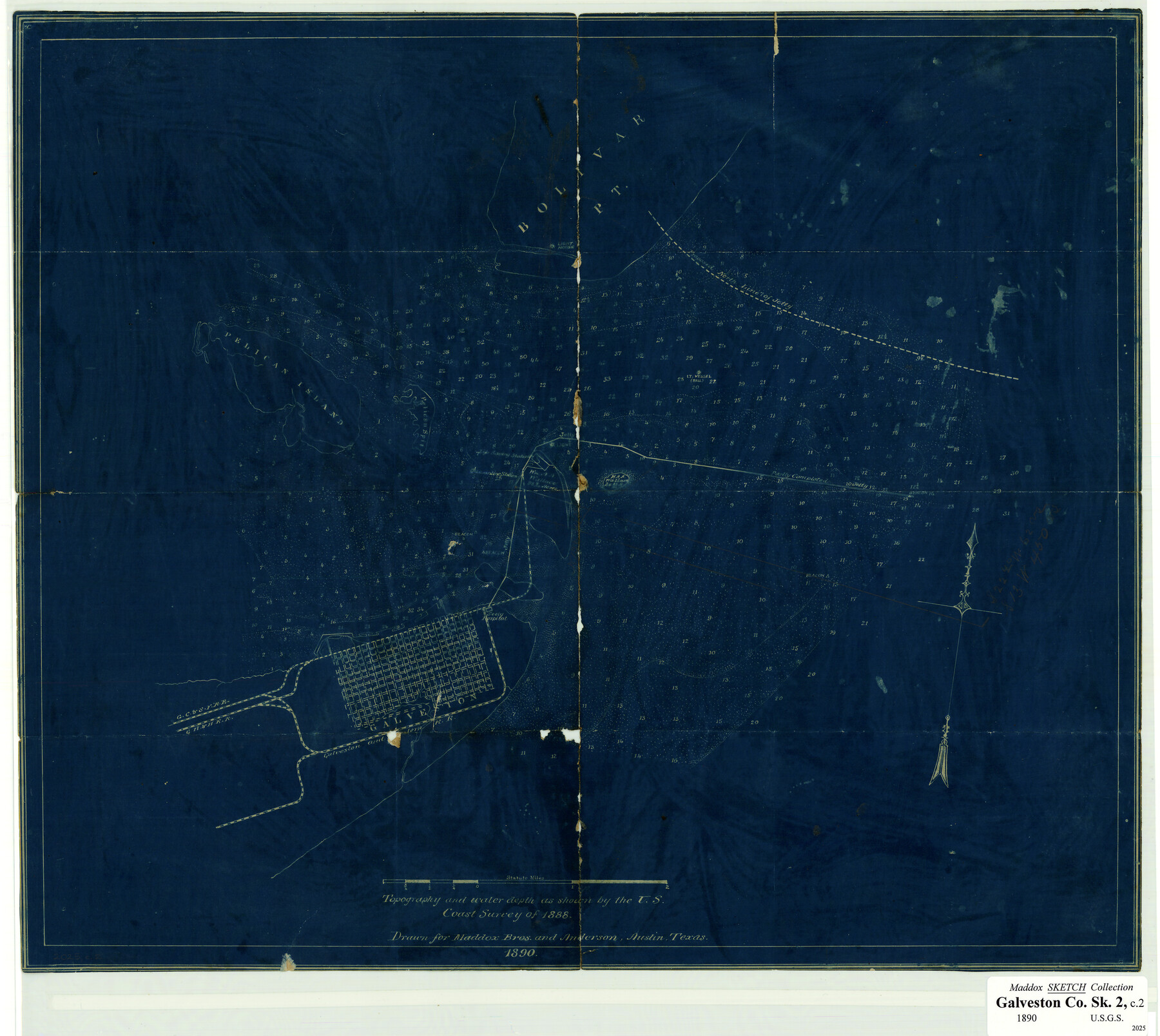
Topography and Water Depth as Shown by the US Coast Survey of 1888
-
Map/Doc
5036
-
Collection
Maddox Collection
-
Object Dates
1890 (Creation Date)
-
Counties
Galveston
-
Subjects
Nautical Charts
-
Height x Width
16.9 x 18.9 inches
42.9 x 48.0 cm
-
Medium
blueprint/diazo
-
Comments
Drawn for Maddox Bros. and Anderson, Austin, Texas.
-
Features
Galveston
GC&SF
GH&H
G&W
Seely Hospital
Bolivar Point
Pelican Island
Pelican Spit
[Bolivar Point] Light House
Part of: Maddox Collection
Sketch of the Designation of Route of the Aransas Channel Harbor & Dock Company's Deep Water Channel

Print $3.00
- Digital $50.00
Sketch of the Designation of Route of the Aransas Channel Harbor & Dock Company's Deep Water Channel
Size 13.2 x 10.0 inches
Map/Doc 4495
Block No. 45 of the H. & T. C. R.R. Co. and Block No. 4T of the T. & N. O. R.R. Co. in Hansford and Ochiltree Cos. as resurveyed by J.L. Long, State Surveyor

Print $20.00
- Digital $50.00
Block No. 45 of the H. & T. C. R.R. Co. and Block No. 4T of the T. & N. O. R.R. Co. in Hansford and Ochiltree Cos. as resurveyed by J.L. Long, State Surveyor
1888
Size 34.1 x 28.1 inches
Map/Doc 75820
Sketch showing the Chas. M. Roberts 53 1/2 acres about 16 miles N of Houston, east of I.&G.N. R.R.

Print $2.00
- Digital $50.00
Sketch showing the Chas. M. Roberts 53 1/2 acres about 16 miles N of Houston, east of I.&G.N. R.R.
Size 8.0 x 5.9 inches
Map/Doc 374
[Kenney's sketch of the surveys in Dickens and Motley Counties]

Print $20.00
- Digital $50.00
[Kenney's sketch of the surveys in Dickens and Motley Counties]
1905
Size 20.1 x 15.7 inches
Map/Doc 367
Rough sketch showing survey made for L.T. Eck Block 14 and part of Block 13, Fairview Park, South Austin, Texas

Print $2.00
- Digital $50.00
Rough sketch showing survey made for L.T. Eck Block 14 and part of Block 13, Fairview Park, South Austin, Texas
1914
Size 9.0 x 14.4 inches
Map/Doc 467
Winkler County, Texas

Print $20.00
- Digital $50.00
Winkler County, Texas
1889
Size 24.6 x 19.0 inches
Map/Doc 658
Map of South Brady Ranch, Concho County, Texas

Print $3.00
- Digital $50.00
Map of South Brady Ranch, Concho County, Texas
1880
Size 12.9 x 10.5 inches
Map/Doc 424
Plat Showing Position of Hancock Tract and the City of Austin

Print $20.00
- Digital $50.00
Plat Showing Position of Hancock Tract and the City of Austin
Size 22.4 x 17.5 inches
Map/Doc 599
Medina County, Texas

Print $20.00
- Digital $50.00
Medina County, Texas
1879
Size 31.8 x 26.4 inches
Map/Doc 579
[Plat Showing San Gabriel & 24th Street Intersection, Outlot 4, Travis County, Texas]
![75795, [Plat Showing San Gabriel & 24th Street Intersection, Outlot 4, Travis County, Texas], Maddox Collection](https://historictexasmaps.com/wmedia_w700/maps/75795.tif.jpg)
Print $2.00
- Digital $50.00
[Plat Showing San Gabriel & 24th Street Intersection, Outlot 4, Travis County, Texas]
Size 11.4 x 8.7 inches
Map/Doc 75795
Terlingua Special Map, The University of Texas Mineral Survey, Brewster County, Texas

Print $20.00
- Digital $50.00
Terlingua Special Map, The University of Texas Mineral Survey, Brewster County, Texas
1902
Size 20.4 x 22.6 inches
Map/Doc 482
[Surveying Sketch of L. Smith, Sidney Shepherd, Kenneth Hyman, et al in Montgomery County]
![625, [Surveying Sketch of L. Smith, Sidney Shepherd, Kenneth Hyman, et al in Montgomery County], Maddox Collection](https://historictexasmaps.com/wmedia_w700/maps/00625.tif.jpg)
Print $2.00
- Digital $50.00
[Surveying Sketch of L. Smith, Sidney Shepherd, Kenneth Hyman, et al in Montgomery County]
Size 7.3 x 10.6 inches
Map/Doc 625
You may also like

[Sketch of Surveys on San Antonio Road]
![41, [Sketch of Surveys on San Antonio Road], General Map Collection](https://historictexasmaps.com/wmedia_w700/maps/41.tif.jpg)
Print $20.00
- Digital $50.00
[Sketch of Surveys on San Antonio Road]
1840
Size 20.6 x 15.4 inches
Map/Doc 41
Southern Pacific Transportation Company Right of Way and Track Map - Main Line

Print $40.00
- Digital $50.00
Southern Pacific Transportation Company Right of Way and Track Map - Main Line
1918
Size 25.4 x 57.6 inches
Map/Doc 82858
Intracoastal Waterway in Texas - Corpus Christi to Point Isabel including Arroyo Colorado to Mo. Pac. R.R. Bridge Near Harlingen

Print $20.00
- Digital $50.00
Intracoastal Waterway in Texas - Corpus Christi to Point Isabel including Arroyo Colorado to Mo. Pac. R.R. Bridge Near Harlingen
1933
Size 27.9 x 41.0 inches
Map/Doc 61868
Comanche County Sketch File 5

Print $4.00
- Digital $50.00
Comanche County Sketch File 5
1848
Size 8.6 x 8.3 inches
Map/Doc 19059
Armstrong County Rolled Sketch 4

Print $40.00
- Digital $50.00
Armstrong County Rolled Sketch 4
1876
Size 37.8 x 70.8 inches
Map/Doc 8426
[Right of Way & Track Map, The Texas & Pacific Ry. Co. Main Line]
![64691, [Right of Way & Track Map, The Texas & Pacific Ry. Co. Main Line], General Map Collection](https://historictexasmaps.com/wmedia_w700/maps/64691.tif.jpg)
Print $20.00
- Digital $50.00
[Right of Way & Track Map, The Texas & Pacific Ry. Co. Main Line]
Size 10.9 x 18.6 inches
Map/Doc 64691
Galveston County Sketch File 11

Print $40.00
- Digital $50.00
Galveston County Sketch File 11
Size 16.3 x 13.2 inches
Map/Doc 23374
Crane County Working Sketch 31

Print $20.00
- Digital $50.00
Crane County Working Sketch 31
1982
Size 34.3 x 37.7 inches
Map/Doc 68308
PSL Field Notes for Blocks C1, C2, and C3 in Pecos and Reeves Counties and Blocks C4 through C10 in Reeves County

PSL Field Notes for Blocks C1, C2, and C3 in Pecos and Reeves Counties and Blocks C4 through C10 in Reeves County
Map/Doc 81671
McMullen County Working Sketch 46

Print $20.00
- Digital $50.00
McMullen County Working Sketch 46
1982
Size 35.2 x 22.0 inches
Map/Doc 70747
Yoakum-Terry County Sketch

Print $20.00
- Digital $50.00
Yoakum-Terry County Sketch
Size 9.4 x 27.3 inches
Map/Doc 91977