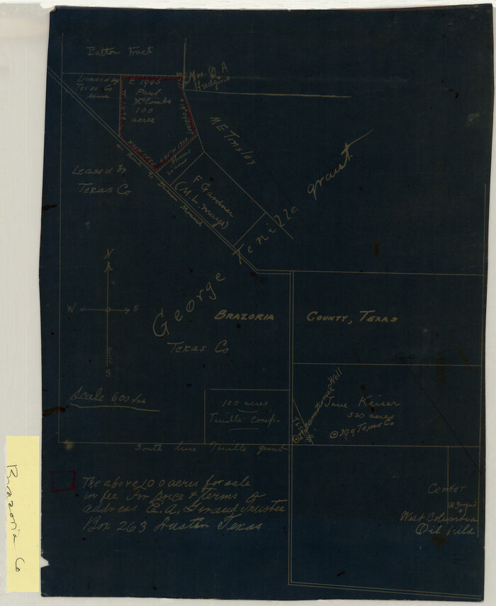
[George Tenille Grant, Brazoria County, Texas]
Print $2.00
- Digital $50.00
[George Tenille Grant, Brazoria County, Texas]
Size: 11.2 x 9.2 inches
10751
Map of the C.C. Browning survey 412 enlarged from General Land Office map of the west part of Travis County, Texas

Print $3.00
- Digital $50.00
Map of the C.C. Browning survey 412 enlarged from General Land Office map of the west part of Travis County, Texas
1920
Size: 11.3 x 9.1 inches
10752
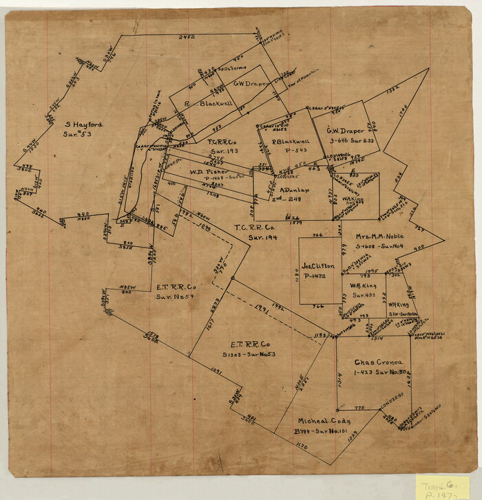
[Surveying sketch of S. Hayford, E. T. R.R. Co., T. C. R. R. Co., et al in Travis County, Texas]
Print $20.00
- Digital $50.00
[Surveying sketch of S. Hayford, E. T. R.R. Co., T. C. R. R. Co., et al in Travis County, Texas]
Size: 18.0 x 17.3 inches
10753
Map of the Western Part of Travis County, Texas

Print $20.00
- Digital $50.00
Map of the Western Part of Travis County, Texas
1919
Size: 36.2 x 29.9 inches
10754
[Map Showing Estivan Martinez "Los Nerios de Tio Ayola" Survey and Surveys North Thereof, Brooks County, Texas]
Print $20.00
- Digital $50.00
[Map Showing Estivan Martinez "Los Nerios de Tio Ayola" Survey and Surveys North Thereof, Brooks County, Texas]
1906
Size: 16.7 x 25.1 inches
10755
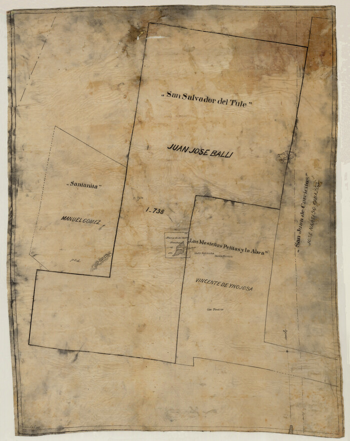
[Sketch of 'San Salvador del Tule', Juan Jose Balli Grant, Hidalgo County, Texas]
Print $20.00
- Digital $50.00
[Sketch of 'San Salvador del Tule', Juan Jose Balli Grant, Hidalgo County, Texas]
Size: 22.0 x 17.5 inches
10756
San Antonio del Encinal as Corrected

Print $20.00
- Digital $50.00
San Antonio del Encinal as Corrected
1916
Size: 31.2 x 31.5 inches
10757
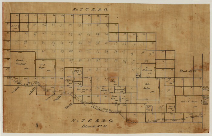
[Sketch of H & T C RR Co. Blocks north of the Canadian River, Hemphill County, Texas]
Print $3.00
- Digital $50.00
[Sketch of H & T C RR Co. Blocks north of the Canadian River, Hemphill County, Texas]
Size: 10.4 x 16.1 inches
10758
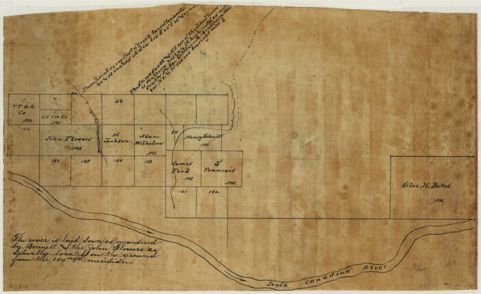
[Sketch Showing Surveys north of South Canadian River, Hemphill County, Texas]
Print $3.00
- Digital $50.00
[Sketch Showing Surveys north of South Canadian River, Hemphill County, Texas]
Size: 9.8 x 14.9 inches
10759
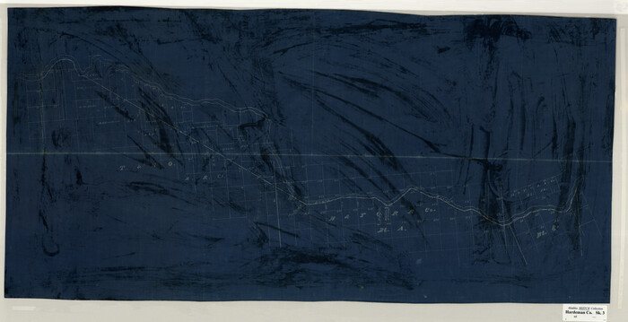
[Sketch Showing Surveys on Pease River in Hardeman County, Texas]
Print $20.00
- Digital $50.00
[Sketch Showing Surveys on Pease River in Hardeman County, Texas]
Size: 19.2 x 37.5 inches
10760
Sketch No. 1, Dickens & Motley Cos.

Print $20.00
- Digital $50.00
Sketch No. 1, Dickens & Motley Cos.
1879
Size: 17.9 x 15.5 inches
10761
Map of Surveys 6, 7, & 8, Block 1, D.B. Gardner 7 1/2, Block L, D.B. Gardner 7, Block T, J.P. Goen

Print $20.00
- Digital $50.00
Map of Surveys 6, 7, & 8, Block 1, D.B. Gardner 7 1/2, Block L, D.B. Gardner 7, Block T, J.P. Goen
1917
Size: 11.0 x 22.6 inches
10762
Map of Survey 8, Block 1, D.B. Gardner

Print $20.00
- Digital $50.00
Map of Survey 8, Block 1, D.B. Gardner
1915
Size: 13.0 x 18.8 inches
10763
Map of Survey 10, Block 1, D.B. Gardner

Print $20.00
- Digital $50.00
Map of Survey 10, Block 1, D.B. Gardner
1915
Size: 16.1 x 18.7 inches
10764
Sketch of Survey 3, Block 1 in Dickens and King Counties

Print $20.00
- Digital $50.00
Sketch of Survey 3, Block 1 in Dickens and King Counties
1914
Size: 10.0 x 27.5 inches
10765
Sketch of Survey 3, Block 1 in Dickens and King Counties

Print $20.00
- Digital $50.00
Sketch of Survey 3, Block 1 in Dickens and King Counties
1914
Size: 10.8 x 28.2 inches
10766
Survey 1, Block 1, D.B. Gardner in Dickens County

Print $20.00
- Digital $50.00
Survey 1, Block 1, D.B. Gardner in Dickens County
1914
Size: 14.9 x 30.4 inches
10767
Map Showing the position of surveys 1 & 2, B.S. & F. Cert 1/356

Print $20.00
- Digital $50.00
Map Showing the position of surveys 1 & 2, B.S. & F. Cert 1/356
1915
Size: 22.0 x 11.1 inches
10768
Survey 4, Block 1, D.B. Gardner

Print $20.00
- Digital $50.00
Survey 4, Block 1, D.B. Gardner
1914
Size: 26.6 x 13.7 inches
10769
Working Sketch in Dickens & King Cos.

Print $20.00
- Digital $50.00
Working Sketch in Dickens & King Cos.
Size: 24.4 x 20.4 inches
10770
Working Sketch in Dickens and Crosby Cos.

Print $20.00
- Digital $50.00
Working Sketch in Dickens and Crosby Cos.
1910
Size: 36.1 x 24.8 inches
10771
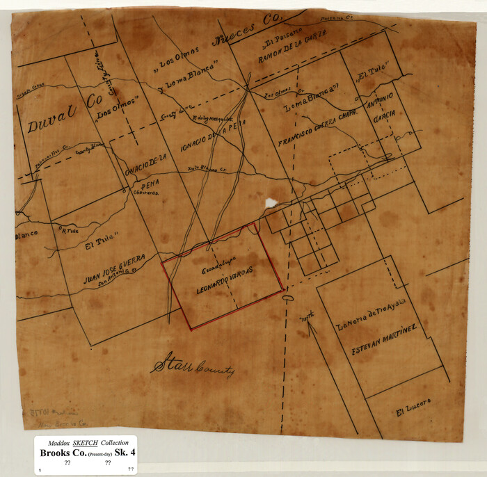
[San Antonio del Encinal Survey and Surveys West Thereof, Brooks County, Texas]
Print $20.00
- Digital $50.00
[San Antonio del Encinal Survey and Surveys West Thereof, Brooks County, Texas]
Size: 18.6 x 24.6 inches
10773
[Santa Rosa Leagues, Brooks & Kenedy Counties, Texas]
Print $20.00
- Digital $50.00
[Santa Rosa Leagues, Brooks & Kenedy Counties, Texas]
Size: 21.0 x 24.6 inches
10774
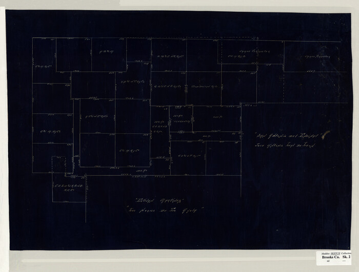
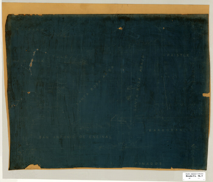
[Sketch of Surveys in Brooks County, Texas]
Print $20.00
- Digital $50.00
[Sketch of Surveys in Brooks County, Texas]
Size: 12.1 x 12.4 inches
10775
Part of original sketch of Block "H" W. & N. W. Ry. Co. Cottle County

Print $20.00
- Digital $50.00
Part of original sketch of Block "H" W. & N. W. Ry. Co. Cottle County
Size: 13.7 x 14.6 inches
10776
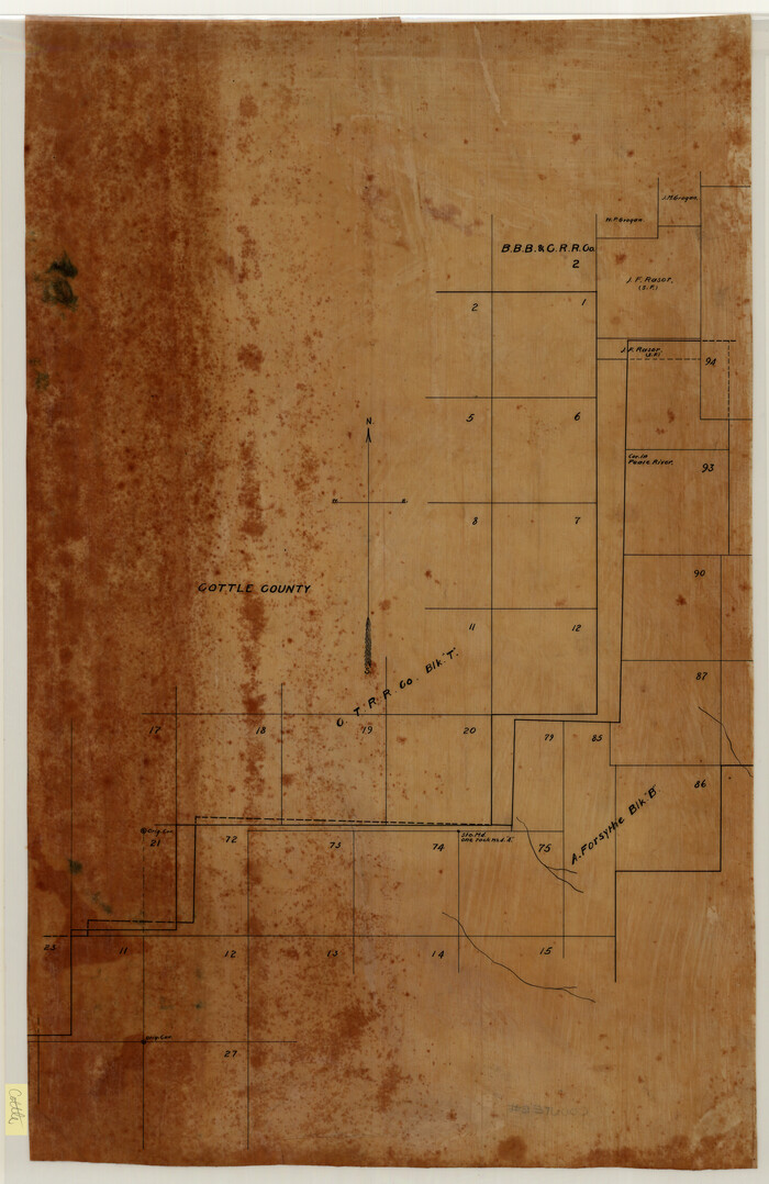
[CTRR Co. Block T, Cottle County, Texas]
Print $20.00
- Digital $50.00
[CTRR Co. Block T, Cottle County, Texas]
Size: 21.5 x 14.0 inches
10777
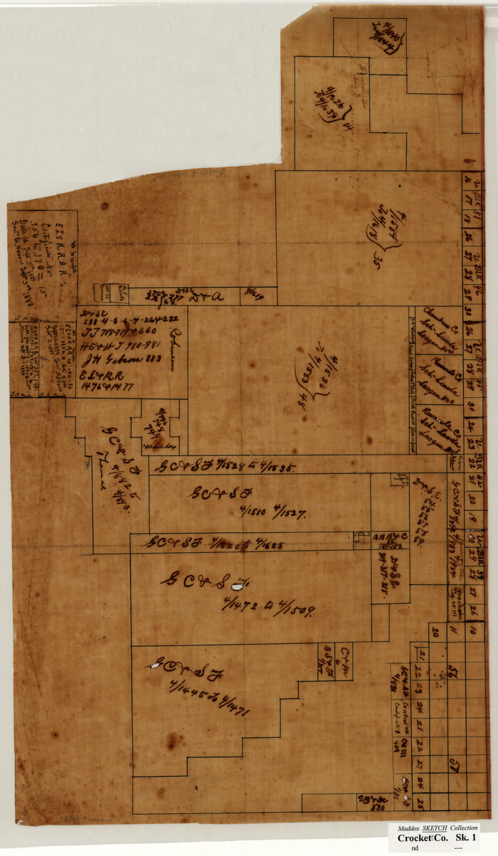
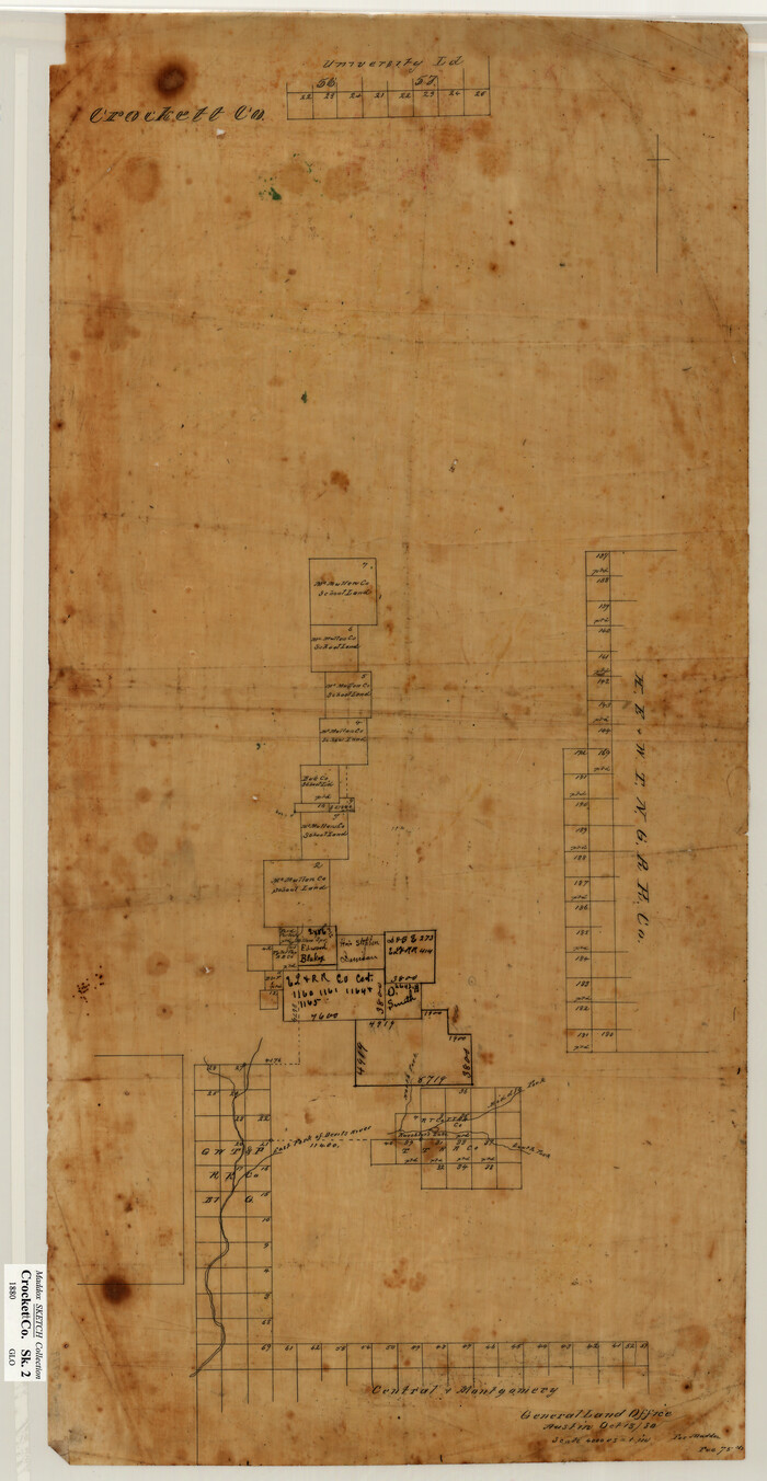
[Sketch of Surveys in Crockett County, Texas]
Print $20.00
- Digital $50.00
[Sketch of Surveys in Crockett County, Texas]
1880
Size: 12.7 x 21.3 inches
10778
[Sketch showing surveys in Sutton and Val Verde Counties, Texas]
Print $20.00
- Digital $50.00
[Sketch showing surveys in Sutton and Val Verde Counties, Texas]
1880
Size: 28.0 x 14.5 inches
10779
Map of Block 1, H. & G. N. R. R. Co., Dickens and Kent Counties Texas

Print $20.00
- Digital $50.00
Map of Block 1, H. & G. N. R. R. Co., Dickens and Kent Counties Texas
1908
Size: 32.0 x 24.2 inches
10780
[McK. & Williams No. 601 and surrounding surveys, Travis County]
Print $20.00
- Digital $50.00
[McK. & Williams No. 601 and surrounding surveys, Travis County]
Size: 18.3 x 12.3 inches
10782
[George Tenille Grant, Brazoria County, Texas]
Print $2.00
- Digital $50.00
[George Tenille Grant, Brazoria County, Texas]
-
Size
11.2 x 9.2 inches
-
Map/Doc
10751
Map of the C.C. Browning survey 412 enlarged from General Land Office map of the west part of Travis County, Texas
Print $3.00
- Digital $50.00
Map of the C.C. Browning survey 412 enlarged from General Land Office map of the west part of Travis County, Texas
1920
-
Size
11.3 x 9.1 inches
-
Map/Doc
10752
-
Creation Date
1920
[Surveying sketch of S. Hayford, E. T. R.R. Co., T. C. R. R. Co., et al in Travis County, Texas]
Print $20.00
- Digital $50.00
[Surveying sketch of S. Hayford, E. T. R.R. Co., T. C. R. R. Co., et al in Travis County, Texas]
-
Size
18.0 x 17.3 inches
-
Map/Doc
10753
Map of the Western Part of Travis County, Texas
Print $20.00
- Digital $50.00
Map of the Western Part of Travis County, Texas
1919
-
Size
36.2 x 29.9 inches
-
Map/Doc
10754
-
Creation Date
1919
[Map Showing Estivan Martinez "Los Nerios de Tio Ayola" Survey and Surveys North Thereof, Brooks County, Texas]
Print $20.00
- Digital $50.00
[Map Showing Estivan Martinez "Los Nerios de Tio Ayola" Survey and Surveys North Thereof, Brooks County, Texas]
1906
-
Size
16.7 x 25.1 inches
-
Map/Doc
10755
-
Creation Date
1906
[Sketch of 'San Salvador del Tule', Juan Jose Balli Grant, Hidalgo County, Texas]
Print $20.00
- Digital $50.00
[Sketch of 'San Salvador del Tule', Juan Jose Balli Grant, Hidalgo County, Texas]
-
Size
22.0 x 17.5 inches
-
Map/Doc
10756
San Antonio del Encinal as Corrected
Print $20.00
- Digital $50.00
San Antonio del Encinal as Corrected
1916
-
Size
31.2 x 31.5 inches
-
Map/Doc
10757
-
Creation Date
1916
[Sketch of H & T C RR Co. Blocks north of the Canadian River, Hemphill County, Texas]
Print $3.00
- Digital $50.00
[Sketch of H & T C RR Co. Blocks north of the Canadian River, Hemphill County, Texas]
-
Size
10.4 x 16.1 inches
-
Map/Doc
10758
[Sketch Showing Surveys north of South Canadian River, Hemphill County, Texas]
Print $3.00
- Digital $50.00
[Sketch Showing Surveys north of South Canadian River, Hemphill County, Texas]
-
Size
9.8 x 14.9 inches
-
Map/Doc
10759
[Sketch Showing Surveys on Pease River in Hardeman County, Texas]
Print $20.00
- Digital $50.00
[Sketch Showing Surveys on Pease River in Hardeman County, Texas]
-
Size
19.2 x 37.5 inches
-
Map/Doc
10760
Sketch No. 1, Dickens & Motley Cos.
Print $20.00
- Digital $50.00
Sketch No. 1, Dickens & Motley Cos.
1879
-
Size
17.9 x 15.5 inches
-
Map/Doc
10761
-
Creation Date
1879
Map of Surveys 6, 7, & 8, Block 1, D.B. Gardner 7 1/2, Block L, D.B. Gardner 7, Block T, J.P. Goen
Print $20.00
- Digital $50.00
Map of Surveys 6, 7, & 8, Block 1, D.B. Gardner 7 1/2, Block L, D.B. Gardner 7, Block T, J.P. Goen
1917
-
Size
11.0 x 22.6 inches
-
Map/Doc
10762
-
Creation Date
1917
Map of Survey 8, Block 1, D.B. Gardner
Print $20.00
- Digital $50.00
Map of Survey 8, Block 1, D.B. Gardner
1915
-
Size
13.0 x 18.8 inches
-
Map/Doc
10763
-
Creation Date
1915
Map of Survey 10, Block 1, D.B. Gardner
Print $20.00
- Digital $50.00
Map of Survey 10, Block 1, D.B. Gardner
1915
-
Size
16.1 x 18.7 inches
-
Map/Doc
10764
-
Creation Date
1915
Sketch of Survey 3, Block 1 in Dickens and King Counties
Print $20.00
- Digital $50.00
Sketch of Survey 3, Block 1 in Dickens and King Counties
1914
-
Size
10.0 x 27.5 inches
-
Map/Doc
10765
-
Creation Date
1914
Sketch of Survey 3, Block 1 in Dickens and King Counties
Print $20.00
- Digital $50.00
Sketch of Survey 3, Block 1 in Dickens and King Counties
1914
-
Size
10.8 x 28.2 inches
-
Map/Doc
10766
-
Creation Date
1914
Survey 1, Block 1, D.B. Gardner in Dickens County
Print $20.00
- Digital $50.00
Survey 1, Block 1, D.B. Gardner in Dickens County
1914
-
Size
14.9 x 30.4 inches
-
Map/Doc
10767
-
Creation Date
1914
Map Showing the position of surveys 1 & 2, B.S. & F. Cert 1/356
Print $20.00
- Digital $50.00
Map Showing the position of surveys 1 & 2, B.S. & F. Cert 1/356
1915
-
Size
22.0 x 11.1 inches
-
Map/Doc
10768
-
Creation Date
1915
Survey 4, Block 1, D.B. Gardner
Print $20.00
- Digital $50.00
Survey 4, Block 1, D.B. Gardner
1914
-
Size
26.6 x 13.7 inches
-
Map/Doc
10769
-
Creation Date
1914
Working Sketch in Dickens & King Cos.
Print $20.00
- Digital $50.00
Working Sketch in Dickens & King Cos.
-
Size
24.4 x 20.4 inches
-
Map/Doc
10770
Working Sketch in Dickens and Crosby Cos.
Print $20.00
- Digital $50.00
Working Sketch in Dickens and Crosby Cos.
1910
-
Size
36.1 x 24.8 inches
-
Map/Doc
10771
-
Creation Date
1910
[San Antonio del Encinal Survey and Surveys West Thereof, Brooks County, Texas]
Print $20.00
- Digital $50.00
[San Antonio del Encinal Survey and Surveys West Thereof, Brooks County, Texas]
-
Size
18.6 x 24.6 inches
-
Map/Doc
10773
[Santa Rosa Leagues, Brooks & Kenedy Counties, Texas]
Print $20.00
- Digital $50.00
[Santa Rosa Leagues, Brooks & Kenedy Counties, Texas]
-
Size
21.0 x 24.6 inches
-
Map/Doc
10774
[Sketch of Surveys in Brooks County, Texas]
Print $20.00
- Digital $50.00
[Sketch of Surveys in Brooks County, Texas]
-
Size
12.1 x 12.4 inches
-
Map/Doc
10775
Part of original sketch of Block "H" W. & N. W. Ry. Co. Cottle County
Print $20.00
- Digital $50.00
Part of original sketch of Block "H" W. & N. W. Ry. Co. Cottle County
-
Size
13.7 x 14.6 inches
-
Map/Doc
10776
[CTRR Co. Block T, Cottle County, Texas]
Print $20.00
- Digital $50.00
[CTRR Co. Block T, Cottle County, Texas]
-
Size
21.5 x 14.0 inches
-
Map/Doc
10777
[Sketch of Surveys in Crockett County, Texas]
Print $20.00
- Digital $50.00
[Sketch of Surveys in Crockett County, Texas]
1880
-
Size
12.7 x 21.3 inches
-
Map/Doc
10778
-
Creation Date
1880
[Sketch showing surveys in Sutton and Val Verde Counties, Texas]
Print $20.00
- Digital $50.00
[Sketch showing surveys in Sutton and Val Verde Counties, Texas]
1880
-
Size
28.0 x 14.5 inches
-
Map/Doc
10779
-
Creation Date
1880
Map of Block 1, H. & G. N. R. R. Co., Dickens and Kent Counties Texas
Print $20.00
- Digital $50.00
Map of Block 1, H. & G. N. R. R. Co., Dickens and Kent Counties Texas
1908
-
Size
32.0 x 24.2 inches
-
Map/Doc
10780
-
Creation Date
1908
[McK. & Williams No. 601 and surrounding surveys, Travis County]
Print $20.00
- Digital $50.00
[McK. & Williams No. 601 and surrounding surveys, Travis County]
-
Size
18.3 x 12.3 inches
-
Map/Doc
10782