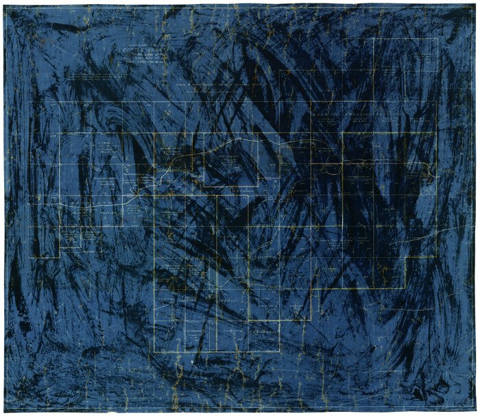
City of Austin, Texas Use District Map

Print $20.00
- Digital $50.00
City of Austin, Texas Use District Map
1939
Size: 42.9 x 32.2 inches
452
Map of Texas in 1836

Print $20.00
- Digital $50.00
Map of Texas in 1836
1936
Size: 24.5 x 19.3 inches
449
Sketch showing subdivision of surveys in Webb Co., Texas

Print $20.00
- Digital $50.00
Sketch showing subdivision of surveys in Webb Co., Texas
1933
Size: 18.2 x 20.1 inches
459
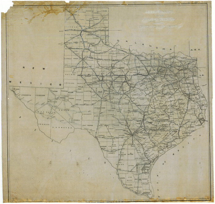
[Highway Map of the State of Texas]
Print $20.00
- Digital $50.00
[Highway Map of the State of Texas]
1923
Size: 44.7 x 46.7 inches
5039
Map of the C.C. Browning survey 412 enlarged from General Land Office map of the west part of Travis County, Texas

Print $3.00
- Digital $50.00
Map of the C.C. Browning survey 412 enlarged from General Land Office map of the west part of Travis County, Texas
1920
Size: 11.3 x 9.1 inches
10752
Map of the H.J. Dorrah survey 16 enlarged from the General Land Office map of the west part of Travis County, Texas

Print $2.00
- Digital $50.00
Map of the H.J. Dorrah survey 16 enlarged from the General Land Office map of the west part of Travis County, Texas
1920
Size: 11.1 x 8.6 inches
612
Map of the Western Part of Travis County, Texas

Print $20.00
- Digital $50.00
Map of the Western Part of Travis County, Texas
1919
Size: 36.2 x 29.9 inches
10754
Map of Townsite of Swearingen, Cottle County, Texas

Print $20.00
- Digital $50.00
Map of Townsite of Swearingen, Cottle County, Texas
1919
Size: 28.1 x 17.1 inches
4463
Map of Townsite of Swearingen, Cottle County, Texas

Print $20.00
- Digital $50.00
Map of Townsite of Swearingen, Cottle County, Texas
1918
Size: 28.8 x 17.4 inches
4464
Plat Town of Swearingen, Cottle Co., Texas

Print $20.00
- Digital $50.00
Plat Town of Swearingen, Cottle Co., Texas
1918
Size: 40.6 x 30.6 inches
4466
Plat Town of Swearingen, Cottle Co., Texas

Print $20.00
- Digital $50.00
Plat Town of Swearingen, Cottle Co., Texas
1918
Size: 39.8 x 30.6 inches
513
Map of Surveys 6, 7, & 8, Block 1, D.B. Gardner 7 1/2, Block L, D.B. Gardner 7, Block T, J.P. Goen

Print $20.00
- Digital $50.00
Map of Surveys 6, 7, & 8, Block 1, D.B. Gardner 7 1/2, Block L, D.B. Gardner 7, Block T, J.P. Goen
1917
Size: 11.0 x 22.6 inches
10762
Working Sketch in Cottle, Foard & Hardeman Counties

Print $20.00
- Digital $50.00
Working Sketch in Cottle, Foard & Hardeman Counties
1917
Size: 26.9 x 28.0 inches
4485
Map of Part of the YL Ranch

Print $20.00
- Digital $50.00
Map of Part of the YL Ranch
1917
Size: 29.1 x 27.3 inches
4442
P.J. Lawless Addition of part of Outlots 29 and 30, Division D, Austin, Texas

Print $20.00
- Digital $50.00
P.J. Lawless Addition of part of Outlots 29 and 30, Division D, Austin, Texas
1916
Size: 13.7 x 17.1 inches
620
Survey of Lots 1 and 2, Desha Bunton Subdivision

Print $20.00
- Digital $50.00
Survey of Lots 1 and 2, Desha Bunton Subdivision
1916
Size: 19.6 x 18.4 inches
487
Saline Ranch in Mason, Kimble and Menard Counties

Print $20.00
- Digital $50.00
Saline Ranch in Mason, Kimble and Menard Counties
1916
Size: 28.3 x 27.2 inches
75806
Saline Ranch in Mason, Kimble and Menard Counties

Print $20.00
- Digital $50.00
Saline Ranch in Mason, Kimble and Menard Counties
1916
Size: 28.2 x 27.1 inches
75807
Saline Ranch in Mason, Kimble and Menard Counties

Print $20.00
- Digital $50.00
Saline Ranch in Mason, Kimble and Menard Counties
1916
Size: 28.6 x 27.4 inches
75808
Littlefield and White's London Property

Print $20.00
- Digital $50.00
Littlefield and White's London Property
1916
Size: 18.5 x 13.0 inches
75796
San Antonio del Encinal as Corrected

Print $20.00
- Digital $50.00
San Antonio del Encinal as Corrected
1916
Size: 31.2 x 31.5 inches
10757
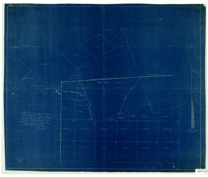
[Surveying Sketch of Jesse McGee, Jas McKim, W. S. Kennard, et al in Sabine and Newton Counties, Texas]
Print $20.00
- Digital $50.00
[Surveying Sketch of Jesse McGee, Jas McKim, W. S. Kennard, et al in Sabine and Newton Counties, Texas]
1916
Size: 32.0 x 37.5 inches
5066
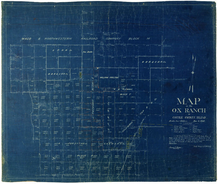
Map of the O-X Ranch in Cottle County, Texas
Print $20.00
- Digital $50.00
Map of the O-X Ranch in Cottle County, Texas
1916
Size: 30.4 x 35.0 inches
4438
Map of the O-X Ranch in Cottle County, Texas

Print $20.00
- Digital $50.00
Map of the O-X Ranch in Cottle County, Texas
1916
Size: 30.4 x 35.7 inches
4439
P.J. Lawless Addition of Part of Outlots 29 and 30, Division D, Austin, Texas.

Print $20.00
- Digital $50.00
P.J. Lawless Addition of Part of Outlots 29 and 30, Division D, Austin, Texas.
1916
Size: 13.6 x 16.6 inches
502
Working Sketch Cottle County
Print $20.00
- Digital $50.00
Working Sketch Cottle County
1916
Size: 31.7 x 29.6 inches
4434
Working Sketch, Cottle County
Print $20.00
- Digital $50.00
Working Sketch, Cottle County
1916
Size: 26.0 x 28.9 inches
4435
Map of the San Antonio del Encinal as Corrected

Print $20.00
- Digital $50.00
Map of the San Antonio del Encinal as Corrected
1916
Size: 28.5 x 30.6 inches
4456
Western portion of the Ward Ranch, Cottle, Foard & Hardeman Counties, Swearingen, Texas sold to Luther T. Clark

Print $20.00
- Digital $50.00
Western portion of the Ward Ranch, Cottle, Foard & Hardeman Counties, Swearingen, Texas sold to Luther T. Clark
1916
Size: 30.4 x 30.7 inches
4460
King County Survey made by A.C. Tackitt and W.D. Twichell

Print $20.00
- Digital $50.00
King County Survey made by A.C. Tackitt and W.D. Twichell
1916
Size: 27.5 x 25.1 inches
5069
City of Austin, Texas Use District Map
Print $20.00
- Digital $50.00
City of Austin, Texas Use District Map
1939
-
Size
42.9 x 32.2 inches
-
Map/Doc
452
-
Creation Date
1939
Map of Texas in 1836
Print $20.00
- Digital $50.00
Map of Texas in 1836
1936
-
Size
24.5 x 19.3 inches
-
Map/Doc
449
-
Creation Date
1936
Sketch showing subdivision of surveys in Webb Co., Texas
Print $20.00
- Digital $50.00
Sketch showing subdivision of surveys in Webb Co., Texas
1933
-
Size
18.2 x 20.1 inches
-
Map/Doc
459
-
Creation Date
1933
[Highway Map of the State of Texas]
Print $20.00
- Digital $50.00
[Highway Map of the State of Texas]
1923
-
Size
44.7 x 46.7 inches
-
Map/Doc
5039
-
Creation Date
1923
Map of the C.C. Browning survey 412 enlarged from General Land Office map of the west part of Travis County, Texas
Print $3.00
- Digital $50.00
Map of the C.C. Browning survey 412 enlarged from General Land Office map of the west part of Travis County, Texas
1920
-
Size
11.3 x 9.1 inches
-
Map/Doc
10752
-
Creation Date
1920
Map of the H.J. Dorrah survey 16 enlarged from the General Land Office map of the west part of Travis County, Texas
Print $2.00
- Digital $50.00
Map of the H.J. Dorrah survey 16 enlarged from the General Land Office map of the west part of Travis County, Texas
1920
-
Size
11.1 x 8.6 inches
-
Map/Doc
612
-
Creation Date
1920
Map of the Western Part of Travis County, Texas
Print $20.00
- Digital $50.00
Map of the Western Part of Travis County, Texas
1919
-
Size
36.2 x 29.9 inches
-
Map/Doc
10754
-
Creation Date
1919
Map of Townsite of Swearingen, Cottle County, Texas
Print $20.00
- Digital $50.00
Map of Townsite of Swearingen, Cottle County, Texas
1919
-
Size
28.1 x 17.1 inches
-
Map/Doc
4463
-
Creation Date
1919
Map of Townsite of Swearingen, Cottle County, Texas
Print $20.00
- Digital $50.00
Map of Townsite of Swearingen, Cottle County, Texas
1918
-
Size
28.8 x 17.4 inches
-
Map/Doc
4464
-
Creation Date
1918
Plat Town of Swearingen, Cottle Co., Texas
Print $20.00
- Digital $50.00
Plat Town of Swearingen, Cottle Co., Texas
1918
-
Size
40.6 x 30.6 inches
-
Map/Doc
4466
-
Creation Date
1918
Plat Town of Swearingen, Cottle Co., Texas
Print $20.00
- Digital $50.00
Plat Town of Swearingen, Cottle Co., Texas
1918
-
Size
39.8 x 30.6 inches
-
Map/Doc
513
-
Creation Date
1918
Map of Surveys 6, 7, & 8, Block 1, D.B. Gardner 7 1/2, Block L, D.B. Gardner 7, Block T, J.P. Goen
Print $20.00
- Digital $50.00
Map of Surveys 6, 7, & 8, Block 1, D.B. Gardner 7 1/2, Block L, D.B. Gardner 7, Block T, J.P. Goen
1917
-
Size
11.0 x 22.6 inches
-
Map/Doc
10762
-
Creation Date
1917
Working Sketch in Cottle, Foard & Hardeman Counties
Print $20.00
- Digital $50.00
Working Sketch in Cottle, Foard & Hardeman Counties
1917
-
Size
26.9 x 28.0 inches
-
Map/Doc
4485
-
Creation Date
1917
Map of Part of the YL Ranch
Print $20.00
- Digital $50.00
Map of Part of the YL Ranch
1917
-
Size
29.1 x 27.3 inches
-
Map/Doc
4442
-
Creation Date
1917
P.J. Lawless Addition of part of Outlots 29 and 30, Division D, Austin, Texas
Print $20.00
- Digital $50.00
P.J. Lawless Addition of part of Outlots 29 and 30, Division D, Austin, Texas
1916
-
Size
13.7 x 17.1 inches
-
Map/Doc
620
-
Creation Date
1916
Survey of Lots 1 and 2, Desha Bunton Subdivision
Print $20.00
- Digital $50.00
Survey of Lots 1 and 2, Desha Bunton Subdivision
1916
-
Size
19.6 x 18.4 inches
-
Map/Doc
487
-
Creation Date
1916
Saline Ranch in Mason, Kimble and Menard Counties
Print $20.00
- Digital $50.00
Saline Ranch in Mason, Kimble and Menard Counties
1916
-
Size
28.3 x 27.2 inches
-
Map/Doc
75806
-
Creation Date
1916
Saline Ranch in Mason, Kimble and Menard Counties
Print $20.00
- Digital $50.00
Saline Ranch in Mason, Kimble and Menard Counties
1916
-
Size
28.2 x 27.1 inches
-
Map/Doc
75807
-
Creation Date
1916
Saline Ranch in Mason, Kimble and Menard Counties
Print $20.00
- Digital $50.00
Saline Ranch in Mason, Kimble and Menard Counties
1916
-
Size
28.6 x 27.4 inches
-
Map/Doc
75808
-
Creation Date
1916
Littlefield and White's London Property
Print $20.00
- Digital $50.00
Littlefield and White's London Property
1916
-
Size
18.5 x 13.0 inches
-
Map/Doc
75796
-
Creation Date
1916
San Antonio del Encinal as Corrected
Print $20.00
- Digital $50.00
San Antonio del Encinal as Corrected
1916
-
Size
31.2 x 31.5 inches
-
Map/Doc
10757
-
Creation Date
1916
[Surveying Sketch of Jesse McGee, Jas McKim, W. S. Kennard, et al in Sabine and Newton Counties, Texas]
Print $20.00
- Digital $50.00
[Surveying Sketch of Jesse McGee, Jas McKim, W. S. Kennard, et al in Sabine and Newton Counties, Texas]
1916
-
Size
32.0 x 37.5 inches
-
Map/Doc
5066
-
Creation Date
1916
Map of the O-X Ranch in Cottle County, Texas
Print $20.00
- Digital $50.00
Map of the O-X Ranch in Cottle County, Texas
1916
-
Size
30.4 x 35.0 inches
-
Map/Doc
4438
-
Creation Date
1916
Map of the O-X Ranch in Cottle County, Texas
Print $20.00
- Digital $50.00
Map of the O-X Ranch in Cottle County, Texas
1916
-
Size
30.4 x 35.7 inches
-
Map/Doc
4439
-
Creation Date
1916
P.J. Lawless Addition of Part of Outlots 29 and 30, Division D, Austin, Texas.
Print $20.00
- Digital $50.00
P.J. Lawless Addition of Part of Outlots 29 and 30, Division D, Austin, Texas.
1916
-
Size
13.6 x 16.6 inches
-
Map/Doc
502
-
Creation Date
1916
Working Sketch Cottle County
Print $20.00
- Digital $50.00
Working Sketch Cottle County
1916
-
Size
31.7 x 29.6 inches
-
Map/Doc
4434
-
Creation Date
1916
Working Sketch, Cottle County
Print $20.00
- Digital $50.00
Working Sketch, Cottle County
1916
-
Size
26.0 x 28.9 inches
-
Map/Doc
4435
-
Creation Date
1916
Map of the San Antonio del Encinal as Corrected
Print $20.00
- Digital $50.00
Map of the San Antonio del Encinal as Corrected
1916
-
Size
28.5 x 30.6 inches
-
Map/Doc
4456
-
Creation Date
1916
Western portion of the Ward Ranch, Cottle, Foard & Hardeman Counties, Swearingen, Texas sold to Luther T. Clark
Print $20.00
- Digital $50.00
Western portion of the Ward Ranch, Cottle, Foard & Hardeman Counties, Swearingen, Texas sold to Luther T. Clark
1916
-
Size
30.4 x 30.7 inches
-
Map/Doc
4460
-
Creation Date
1916
King County Survey made by A.C. Tackitt and W.D. Twichell
Print $20.00
- Digital $50.00
King County Survey made by A.C. Tackitt and W.D. Twichell
1916
-
Size
27.5 x 25.1 inches
-
Map/Doc
5069
-
Creation Date
1916