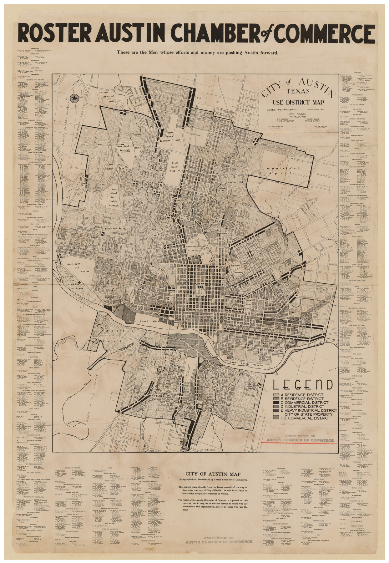
City of Austin, Texas Use District Map
-
Map/Doc
452
-
Collection
Maddox Collection
-
Object Dates
1939 (Creation Date)
-
People and Organizations
Austin Chamber of Commerce (Publisher)
-
Counties
Travis
-
Subjects
City
-
Height x Width
42.9 x 32.2 inches
109.0 x 81.8 cm
-
Comments
Adopted with contributions from the 2009 State Employee Charitable Campaign (SECC).
-
URLs
https://medium.com/save-texas-history/city-of-austin-texas-use-district-map-1939-by-austin-chamber-of-commerce-a739469b3fb5#.1ssewkgs2
Part of: Maddox Collection
P.J. Lawless Addition of Part of Outlots 29 and 30, Division D, Austin, Texas.

Print $20.00
- Digital $50.00
P.J. Lawless Addition of Part of Outlots 29 and 30, Division D, Austin, Texas.
1916
Size 13.6 x 16.6 inches
Map/Doc 502
Sketch in Atascosa County

Print $3.00
- Digital $50.00
Sketch in Atascosa County
1890
Size 12.6 x 11.4 inches
Map/Doc 578
Midland County, Texas

Print $20.00
- Digital $50.00
Midland County, Texas
1888
Size 22.4 x 17.5 inches
Map/Doc 653
Castro County, Texas

Print $20.00
- Digital $50.00
Castro County, Texas
1891
Size 24.5 x 20.4 inches
Map/Doc 694
Map of surveys 191 & 192 T. C. R.R. Co. in Travis County, Texas

Print $20.00
- Digital $50.00
Map of surveys 191 & 192 T. C. R.R. Co. in Travis County, Texas
1915
Size 20.7 x 12.9 inches
Map/Doc 75555
Map of Nacogdoches County, Texas

Print $20.00
- Digital $50.00
Map of Nacogdoches County, Texas
1881
Size 24.6 x 21.1 inches
Map/Doc 585
[Joaquin Galan Grant, Webb County]
![583, [Joaquin Galan Grant, Webb County], Maddox Collection](https://historictexasmaps.com/wmedia_w700/maps/583-1.tif.jpg)
Print $20.00
- Digital $50.00
[Joaquin Galan Grant, Webb County]
1882
Size 12.4 x 11.7 inches
Map/Doc 583
San Antonio del Encinal as Corrected

Print $20.00
- Digital $50.00
San Antonio del Encinal as Corrected
1916
Size 31.2 x 31.5 inches
Map/Doc 10757
Copy of sketch in Nacogdoches Donation 724 on file in GLO

Print $20.00
- Digital $50.00
Copy of sketch in Nacogdoches Donation 724 on file in GLO
1890
Size 18.0 x 10.9 inches
Map/Doc 75803
Marion County, Texas

Print $20.00
- Digital $50.00
Marion County, Texas
1879
Size 15.0 x 20.7 inches
Map/Doc 651
Map of Tyler County, Texas

Print $20.00
- Digital $50.00
Map of Tyler County, Texas
1882
Size 28.3 x 21.4 inches
Map/Doc 669
Midland County, Texas

Print $20.00
- Digital $50.00
Midland County, Texas
1880
Size 25.5 x 21.5 inches
Map/Doc 740
You may also like
Castro County Sketch File 8

Print $20.00
- Digital $50.00
Castro County Sketch File 8
1908
Size 27.2 x 24.0 inches
Map/Doc 11060
[Blotter for Roads in Moore County]
![91530, [Blotter for Roads in Moore County], Twichell Survey Records](https://historictexasmaps.com/wmedia_w700/maps/91530-1.tif.jpg)
Print $20.00
- Digital $50.00
[Blotter for Roads in Moore County]
Size 32.5 x 32.0 inches
Map/Doc 91530
Hardeman County Boundary File 3b

Print $12.00
- Digital $50.00
Hardeman County Boundary File 3b
Size 14.1 x 8.7 inches
Map/Doc 54386
Hall County Rolled Sketch 3

Print $20.00
- Digital $50.00
Hall County Rolled Sketch 3
1890
Size 12.6 x 22.6 inches
Map/Doc 6048
Flight Mission No. BRE-1P, Frame 34, Nueces County

Print $20.00
- Digital $50.00
Flight Mission No. BRE-1P, Frame 34, Nueces County
1956
Size 18.4 x 22.2 inches
Map/Doc 86630
Aransas County Sketch File 10

Print $4.00
- Digital $50.00
Aransas County Sketch File 10
1871
Size 7.3 x 9.4 inches
Map/Doc 13116
Eastland County Working Sketch 5

Print $20.00
- Digital $50.00
Eastland County Working Sketch 5
1918
Size 16.1 x 19.3 inches
Map/Doc 68786
Hutchinson County Working Sketch 14

Print $20.00
- Digital $50.00
Hutchinson County Working Sketch 14
1930
Size 18.4 x 25.8 inches
Map/Doc 66372
Pecos County Rolled Sketch 115

Print $20.00
- Digital $50.00
Pecos County Rolled Sketch 115
1943
Size 24.0 x 21.6 inches
Map/Doc 7257
Hood County Sketch File 16

Print $4.00
- Digital $50.00
Hood County Sketch File 16
1860
Size 10.2 x 8.2 inches
Map/Doc 26597
Maverick County Working Sketch 3

Print $20.00
- Digital $50.00
Maverick County Working Sketch 3
1939
Size 34.4 x 24.8 inches
Map/Doc 70895
Orange County Working Sketch 43

Print $20.00
- Digital $50.00
Orange County Working Sketch 43
1980
Size 18.3 x 18.4 inches
Map/Doc 71375