Mirando City, Webb County, Texas

Print $40.00
- Digital $50.00
Mirando City, Webb County, Texas
1937
Size: 60.0 x 36.2 inches
10132
Zapata County Sketch File 9

Print $40.00
- Digital $50.00
Zapata County Sketch File 9
1917
Size: 31.8 x 49.4 inches
10439
Zapata County Sketch File 10

Print $40.00
- Digital $50.00
Zapata County Sketch File 10
1917
Size: 51.0 x 32.6 inches
10440
Brazoria County Rolled Sketch 23

Print $20.00
- Digital $50.00
Brazoria County Rolled Sketch 23
1931
Size: 39.2 x 37.3 inches
10691
Austin County Sketch File 12

Print $40.00
- Digital $50.00
Austin County Sketch File 12
Size: 22.5 x 18.0 inches
10876
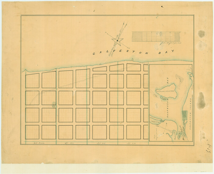
[Town lots on Galveston Island]
Print $20.00
- Digital $50.00
[Town lots on Galveston Island]
1839
Size: 18.8 x 23.0 inches
11
Wharton County Sketch File 13a

Print $20.00
- Digital $50.00
Wharton County Sketch File 13a
1894
Size: 18.3 x 28.7 inches
12663
Aransas County Sketch File 27

Print $23.00
- Digital $50.00
Aransas County Sketch File 27
Size: 12.2 x 18.2 inches
13224
City of Alpine - Texas, Brewster County

Print $20.00
- Digital $50.00
City of Alpine - Texas, Brewster County
1945
Size: 11.4 x 19.4 inches
1683
Map of Jefferson as owned by Allen Urquhart

Print $20.00
- Digital $50.00
Map of Jefferson as owned by Allen Urquhart
1850
Size: 25.1 x 16.6 inches
1684
Lampasas River, City of Lampasas, Lampasas Sheet/Sulphur & Burleson Creeks

Print $20.00
- Digital $50.00
Lampasas River, City of Lampasas, Lampasas Sheet/Sulphur & Burleson Creeks
1937
Size: 33.4 x 19.3 inches
16956
Map of the Fair Grounds Addition showing subdivisions of Out-lots 39, 49, 50 & 60, Division "O" in the City of Austin

Print $20.00
- Digital $50.00
Map of the Fair Grounds Addition showing subdivisions of Out-lots 39, 49, 50 & 60, Division "O" in the City of Austin
1909
Size: 21.4 x 13.3 inches
2022
Plan of Driving Park Addition composed of Out-lots 37, 38, 39, 49, 50, 60, & 61, Division "O" in the City of Austin

Print $20.00
- Digital $50.00
Plan of Driving Park Addition composed of Out-lots 37, 38, 39, 49, 50, 60, & 61, Division "O" in the City of Austin
1910
Size: 18.4 x 15.9 inches
2024
Galveston Island, showing division into lots

Print $40.00
- Digital $50.00
Galveston Island, showing division into lots
1839
Size: 76.9 x 33.3 inches
2036
Map of the City of Galveston Situated on the East end of Galveston Island

Print $20.00
- Digital $50.00
Map of the City of Galveston Situated on the East end of Galveston Island
1838
Size: 22.0 x 38.1 inches
2170
Plan of the City of Calhoun

Print $40.00
- Digital $50.00
Plan of the City of Calhoun
1839
Size: 49.7 x 58.9 inches
2175
Plan of the City of Austin

Print $40.00
- Digital $50.00
Plan of the City of Austin
1840
Size: 54.0 x 38.9 inches
2176
A Topographical Map of the Government Tract Adjoining the City of Austin

Print $20.00
- Digital $50.00
A Topographical Map of the Government Tract Adjoining the City of Austin
1840
Size: 40.7 x 36.1 inches
2177
A Topographical Map of the Government Tract Adjoining the City of Austin

Print $20.00
- Digital $50.00
A Topographical Map of the Government Tract Adjoining the City of Austin
1840
Size: 44.1 x 38.4 inches
2178
Plan of the City of Austin

Print $40.00
- Digital $50.00
Plan of the City of Austin
1840
Size: 57.3 x 42.0 inches
2179
A Topographical Map of the Government Tract adjoining the City of Austin

Print $20.00
- Digital $50.00
A Topographical Map of the Government Tract adjoining the City of Austin
1840
Size: 41.9 x 37.8 inches
2180
Karte von Indian Point od Indianola / Karte der Stadt Neu Braunfels / Karte der Stadt Friedrichsburg / Hafen von Indian Point oder Indianola

Print $20.00
- Digital $50.00
Karte von Indian Point od Indianola / Karte der Stadt Neu Braunfels / Karte der Stadt Friedrichsburg / Hafen von Indian Point oder Indianola
1850
Size: 13.6 x 19.4 inches
2182
Sketch of Maneuver Tract

Print $20.00
- Digital $50.00
Sketch of Maneuver Tract
1870
Size: 18.5 x 14.4 inches
2184
Map of the Town of Harrold, Wilbarger County, Texas on the line of the Fort Worth and Denver City Railway

Print $20.00
- Digital $50.00
Map of the Town of Harrold, Wilbarger County, Texas on the line of the Fort Worth and Denver City Railway
1887
Size: 31.2 x 28.6 inches
2186
Frank Lerch's Map of San Angelo and Additions

Print $20.00
- Digital $50.00
Frank Lerch's Map of San Angelo and Additions
1880
Size: 36.6 x 26.3 inches
2188
Topographical Map of the City of Austin

Print $20.00
- Digital $50.00
Topographical Map of the City of Austin
1887
Size: 43.1 x 41.1 inches
2189
Mirando City, Webb County, Texas
Print $40.00
- Digital $50.00
Mirando City, Webb County, Texas
1937
-
Size
60.0 x 36.2 inches
-
Map/Doc
10132
-
Creation Date
1937
Zapata County Sketch File 9
Print $40.00
- Digital $50.00
Zapata County Sketch File 9
1917
-
Size
31.8 x 49.4 inches
-
Map/Doc
10439
-
Creation Date
1917
Zapata County Sketch File 10
Print $40.00
- Digital $50.00
Zapata County Sketch File 10
1917
-
Size
51.0 x 32.6 inches
-
Map/Doc
10440
-
Creation Date
1917
Brazoria County Rolled Sketch 23
Print $20.00
- Digital $50.00
Brazoria County Rolled Sketch 23
1931
-
Size
39.2 x 37.3 inches
-
Map/Doc
10691
-
Creation Date
1931
Austin County Sketch File 12
Print $40.00
- Digital $50.00
Austin County Sketch File 12
-
Size
22.5 x 18.0 inches
-
Map/Doc
10876
[Town lots on Galveston Island]
Print $20.00
- Digital $50.00
[Town lots on Galveston Island]
1839
-
Size
18.8 x 23.0 inches
-
Map/Doc
11
-
Creation Date
1839
Wharton County Sketch File 13a
Print $20.00
- Digital $50.00
Wharton County Sketch File 13a
1894
-
Size
18.3 x 28.7 inches
-
Map/Doc
12663
-
Creation Date
1894
Aransas County Sketch File 27
Print $23.00
- Digital $50.00
Aransas County Sketch File 27
-
Size
12.2 x 18.2 inches
-
Map/Doc
13224
Johnson City

Print $40.00
- Digital $50.00
Johnson City
1890
-
Size
14.1 x 17.2 inches
-
Map/Doc
14648
-
Creation Date
1890
City of Alpine - Texas, Brewster County
Print $20.00
- Digital $50.00
City of Alpine - Texas, Brewster County
1945
-
Size
11.4 x 19.4 inches
-
Map/Doc
1683
-
Creation Date
1945
Map of Jefferson as owned by Allen Urquhart
Print $20.00
- Digital $50.00
Map of Jefferson as owned by Allen Urquhart
1850
-
Size
25.1 x 16.6 inches
-
Map/Doc
1684
-
Creation Date
1850
Map of the City of Austin Texas

Map of the City of Austin Texas
1933
-
Size
22.6 x 17.6 inches
-
Map/Doc
1685
-
Creation Date
1933
Lampasas River, City of Lampasas, Lampasas Sheet/Sulphur & Burleson Creeks
Print $20.00
- Digital $50.00
Lampasas River, City of Lampasas, Lampasas Sheet/Sulphur & Burleson Creeks
1937
-
Size
33.4 x 19.3 inches
-
Map/Doc
16956
-
Creation Date
1937
Galveston Island

Print $20.00
- Digital $50.00
Galveston Island
1837
-
Size
23.5 x 40.0 inches
-
Map/Doc
1954
-
Creation Date
1837
Galveston Island

Print $20.00
- Digital $50.00
Galveston Island
1837
-
Size
24.1 x 37.2 inches
-
Map/Doc
2009
-
Creation Date
1837
Map of the Fair Grounds Addition showing subdivisions of Out-lots 39, 49, 50 & 60, Division "O" in the City of Austin
Print $20.00
- Digital $50.00
Map of the Fair Grounds Addition showing subdivisions of Out-lots 39, 49, 50 & 60, Division "O" in the City of Austin
1909
-
Size
21.4 x 13.3 inches
-
Map/Doc
2022
-
Creation Date
1909
Plan of Driving Park Addition composed of Out-lots 37, 38, 39, 49, 50, 60, & 61, Division "O" in the City of Austin
Print $20.00
- Digital $50.00
Plan of Driving Park Addition composed of Out-lots 37, 38, 39, 49, 50, 60, & 61, Division "O" in the City of Austin
1910
-
Size
18.4 x 15.9 inches
-
Map/Doc
2024
-
Creation Date
1910
Galveston Island, showing division into lots
Print $40.00
- Digital $50.00
Galveston Island, showing division into lots
1839
-
Size
76.9 x 33.3 inches
-
Map/Doc
2036
-
Creation Date
1839
Map of the City of Galveston Situated on the East end of Galveston Island
Print $20.00
- Digital $50.00
Map of the City of Galveston Situated on the East end of Galveston Island
1838
-
Size
22.0 x 38.1 inches
-
Map/Doc
2170
-
Creation Date
1838
Plan of the City of Calhoun
Print $40.00
- Digital $50.00
Plan of the City of Calhoun
1839
-
Size
49.7 x 58.9 inches
-
Map/Doc
2175
-
Creation Date
1839
Plan of the City of Austin
Print $40.00
- Digital $50.00
Plan of the City of Austin
1840
-
Size
54.0 x 38.9 inches
-
Map/Doc
2176
-
Creation Date
1840
A Topographical Map of the Government Tract Adjoining the City of Austin
Print $20.00
- Digital $50.00
A Topographical Map of the Government Tract Adjoining the City of Austin
1840
-
Size
40.7 x 36.1 inches
-
Map/Doc
2177
-
Creation Date
1840
A Topographical Map of the Government Tract Adjoining the City of Austin
Print $20.00
- Digital $50.00
A Topographical Map of the Government Tract Adjoining the City of Austin
1840
-
Size
44.1 x 38.4 inches
-
Map/Doc
2178
-
Creation Date
1840
Plan of the City of Austin
Print $40.00
- Digital $50.00
Plan of the City of Austin
1840
-
Size
57.3 x 42.0 inches
-
Map/Doc
2179
-
Creation Date
1840
A Topographical Map of the Government Tract adjoining the City of Austin
Print $20.00
- Digital $50.00
A Topographical Map of the Government Tract adjoining the City of Austin
1840
-
Size
41.9 x 37.8 inches
-
Map/Doc
2180
-
Creation Date
1840
Karte von Indian Point od Indianola / Karte der Stadt Neu Braunfels / Karte der Stadt Friedrichsburg / Hafen von Indian Point oder Indianola
Print $20.00
- Digital $50.00
Karte von Indian Point od Indianola / Karte der Stadt Neu Braunfels / Karte der Stadt Friedrichsburg / Hafen von Indian Point oder Indianola
1850
-
Size
13.6 x 19.4 inches
-
Map/Doc
2182
-
Creation Date
1850
Sketch of Maneuver Tract
Print $20.00
- Digital $50.00
Sketch of Maneuver Tract
1870
-
Size
18.5 x 14.4 inches
-
Map/Doc
2184
-
Creation Date
1870
Map of the Town of Harrold, Wilbarger County, Texas on the line of the Fort Worth and Denver City Railway
Print $20.00
- Digital $50.00
Map of the Town of Harrold, Wilbarger County, Texas on the line of the Fort Worth and Denver City Railway
1887
-
Size
31.2 x 28.6 inches
-
Map/Doc
2186
-
Creation Date
1887
Frank Lerch's Map of San Angelo and Additions
Print $20.00
- Digital $50.00
Frank Lerch's Map of San Angelo and Additions
1880
-
Size
36.6 x 26.3 inches
-
Map/Doc
2188
-
Creation Date
1880
Topographical Map of the City of Austin
Print $20.00
- Digital $50.00
Topographical Map of the City of Austin
1887
-
Size
43.1 x 41.1 inches
-
Map/Doc
2189
-
Creation Date
1887