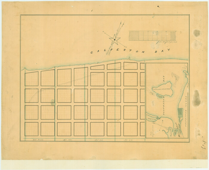
[Town lots on Galveston Island]
Print $20.00
- Digital $50.00
[Town lots on Galveston Island]
1839
Size: 18.8 x 23.0 inches
11
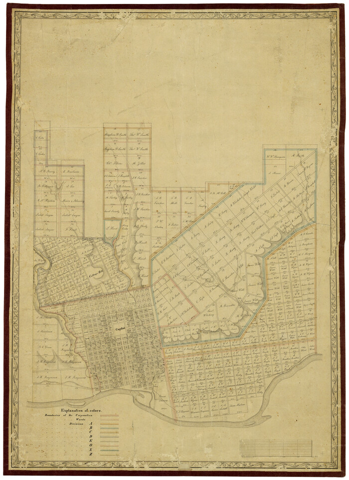
[Reverse of] Plan of the City of Austin
Print $20.00
[Reverse of] Plan of the City of Austin
1839
Size: 19.2 x 24.3 inches
76228
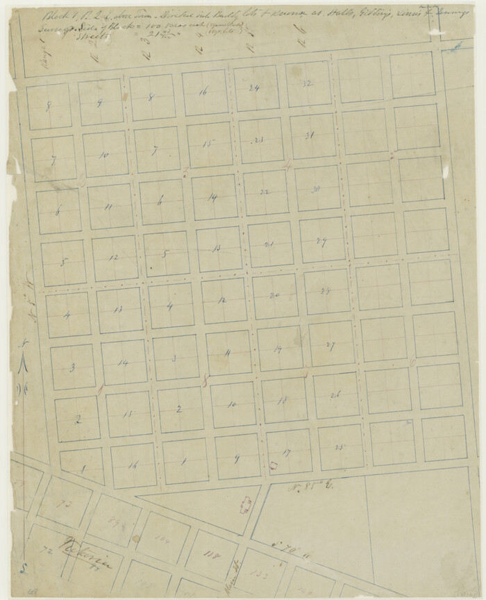
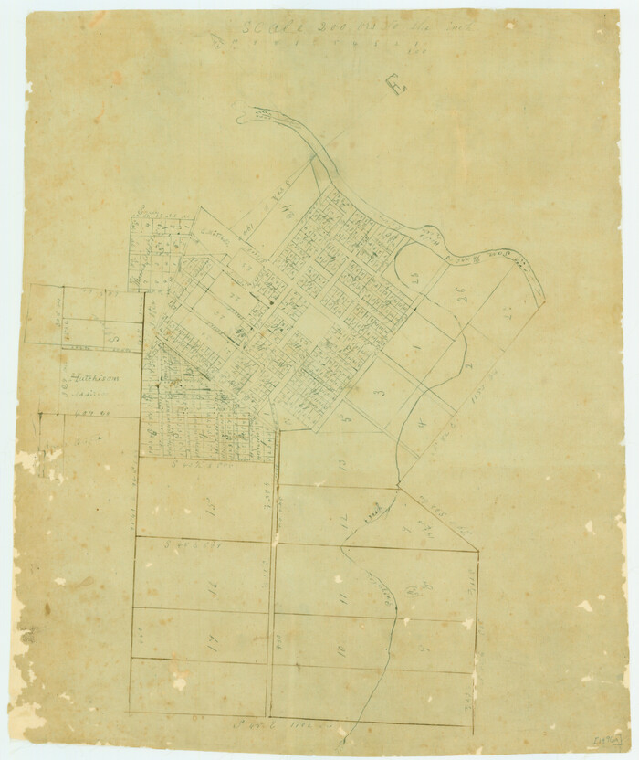
[Plat of the Town of Lockhart]

Print $20.00
- Digital $50.00
[Plat of the Town of Lockhart]
Size: 19.5 x 25.0 inches
82534
[Plat of Victoria, Texas]
Print $20.00
[Plat of Victoria, Texas]
1850
Size: 14.1 x 11.5 inches
76270
[Plat of San Marcos, Texas]
Print $20.00
[Plat of San Marcos, Texas]
1890
Size: 18.9 x 15.9 inches
79312
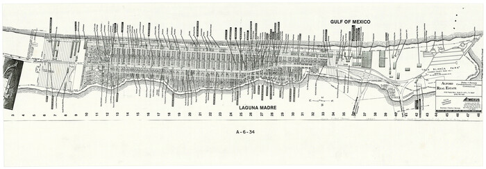
[Map of the City of South Padre Island]
Print $20.00
- Digital $50.00
[Map of the City of South Padre Island]
1993
Size: 12.5 x 36.5 inches
3212
[Map of the City of Austin]
Print $20.00
- Digital $50.00
[Map of the City of Austin]
1856
Size: 29.1 x 21.5 inches
4802
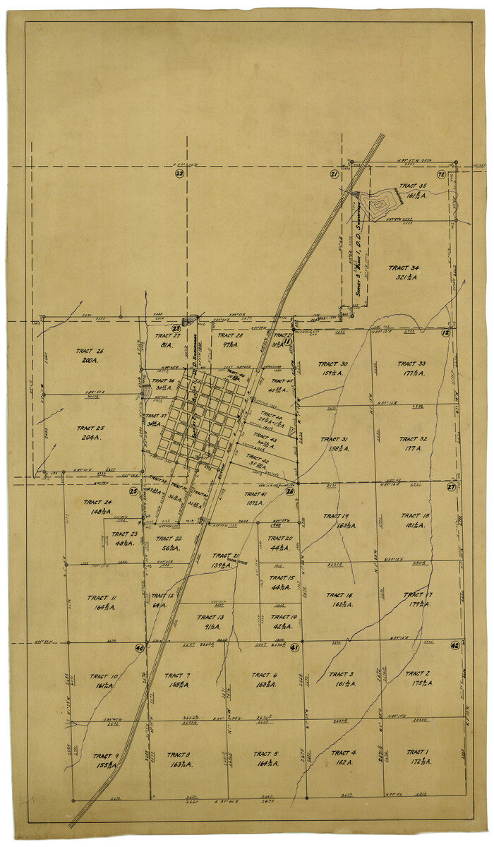
[Map of Townsite of Swearingen, Cottle County, Texas]
Print $20.00
- Digital $50.00
[Map of Townsite of Swearingen, Cottle County, Texas]
Size: 28.8 x 17.8 inches
4465
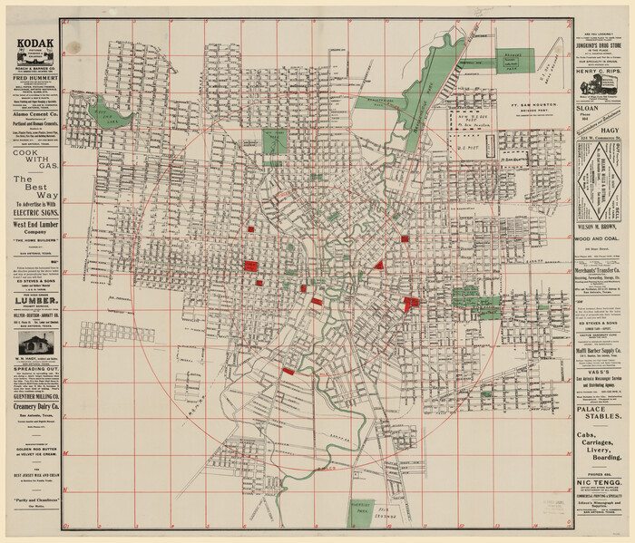
[Map of San Antonio, Texas]
Print $20.00
- Digital $50.00
[Map of San Antonio, Texas]
1895
Size: 29.4 x 34.5 inches
93399
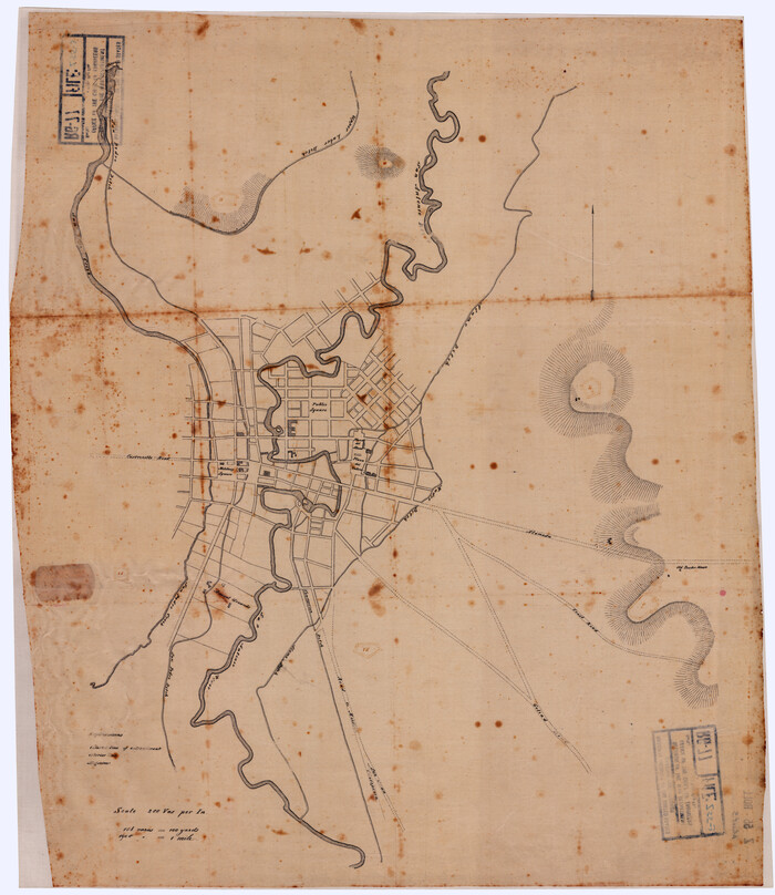
[Map of Area near Alamo showing proposed fortifications]
Print $20.00
[Map of Area near Alamo showing proposed fortifications]
1863
Size: 31.9 x 27.7 inches
88603
[Map Showing Location and Right of Way of Proposed Groins]
Print $4.00
- Digital $50.00
[Map Showing Location and Right of Way of Proposed Groins]
Size: 13.4 x 24.4 inches
73623
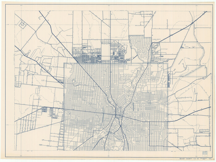
[General Highway Map Supplementary Sheet Showing Detail of Cities and Towns in Bexar County Texas]
Print $20.00
[General Highway Map Supplementary Sheet Showing Detail of Cities and Towns in Bexar County Texas]
1936
Size: 18.7 x 24.9 inches
76289
[Dennis Corwin's Map of Survey for R. N. Graham]
Print $2.00
- Digital $50.00
[Dennis Corwin's Map of Survey for R. N. Graham]
Size: 11.1 x 8.5 inches
83427
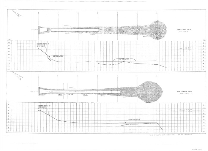
[10th St and 29th St Groins - Galveston]
Print $6.00
- Digital $50.00
[10th St and 29th St Groins - Galveston]
1983
Size: 25.6 x 35.2 inches
73621
Zapata County Sketch File 9

Print $40.00
- Digital $50.00
Zapata County Sketch File 9
1917
Size: 31.8 x 49.4 inches
10439
Zapata County Sketch File 10

Print $40.00
- Digital $50.00
Zapata County Sketch File 10
1917
Size: 51.0 x 32.6 inches
10440
Worley's Map of Greater Dallas

Print $20.00
Worley's Map of Greater Dallas
1905
Size: 34.9 x 25.4 inches
79319
Wichita Falls, Wichita County, Texas

Print $20.00
- Digital $50.00
Wichita Falls, Wichita County, Texas
Size: 32.0 x 22.6 inches
96791
Whitehead Second Addition, City of Lubbock

Print $20.00
- Digital $50.00
Whitehead Second Addition, City of Lubbock
1951
Size: 14.1 x 24.0 inches
92778
What to See - Where to Go in El Paso, Texas

What to See - Where to Go in El Paso, Texas
1929
Size: 9.4 x 8.4 inches
97048
Wharton County Sketch File 13a

Print $20.00
- Digital $50.00
Wharton County Sketch File 13a
1894
Size: 18.3 x 28.7 inches
12663
West Houston: Hwy. 6 from Spencer Rd. in the North to South of Sugar Land. From Wilcrest Dr. in the East to and including Katy.

West Houston: Hwy. 6 from Spencer Rd. in the North to South of Sugar Land. From Wilcrest Dr. in the East to and including Katy.
Size: 35.4 x 22.8 inches
94335
[Town plat of San Marcos]
![83002, [Town plat of San Marcos], Non-GLO Digital Images](https://historictexasmaps.com/wmedia_w700/maps/83002.tif.jpg)
Print $20.00
[Town plat of San Marcos]
-
Size
15.8 x 10.1 inches
-
Map/Doc
83002
[Town lots on Galveston Island]
Print $20.00
- Digital $50.00
[Town lots on Galveston Island]
1839
-
Size
18.8 x 23.0 inches
-
Map/Doc
11
-
Creation Date
1839
[Town Plat of Galveston]
![76258, [Town Plat of Galveston], Texas State Library and Archives](https://historictexasmaps.com/wmedia_w700/maps/76258.tif.jpg)
Print $20.00
[Town Plat of Galveston]
1877
-
Size
9.1 x 14.5 inches
-
Map/Doc
76258
-
Creation Date
1877
[Reverse of] Plan of the City of Austin
Print $20.00
[Reverse of] Plan of the City of Austin
1839
-
Size
19.2 x 24.3 inches
-
Map/Doc
76228
-
Creation Date
1839
[Plat of the Town of Lockhart]
Print $20.00
- Digital $50.00
[Plat of the Town of Lockhart]
-
Size
19.5 x 25.0 inches
-
Map/Doc
82534
[Plat of Victoria, Texas]
Print $20.00
[Plat of Victoria, Texas]
1850
-
Size
14.1 x 11.5 inches
-
Map/Doc
76270
-
Creation Date
1850
[Plat of San Marcos, Texas]
Print $20.00
[Plat of San Marcos, Texas]
1890
-
Size
18.9 x 15.9 inches
-
Map/Doc
79312
-
Creation Date
1890
[Metropolitan Areas of Texas]
![96824, [Metropolitan Areas of Texas], General Map Collection](https://historictexasmaps.com/wmedia_w700/maps/96824.tif.jpg)
[Metropolitan Areas of Texas]
1994
-
Size
33.6 x 36.1 inches
-
Map/Doc
96824
-
Creation Date
1994
[Map of the City of South Padre Island]
Print $20.00
- Digital $50.00
[Map of the City of South Padre Island]
1993
-
Size
12.5 x 36.5 inches
-
Map/Doc
3212
-
Creation Date
1993
[Map of the City of Austin]
Print $20.00
- Digital $50.00
[Map of the City of Austin]
1856
-
Size
29.1 x 21.5 inches
-
Map/Doc
4802
-
Creation Date
1856
[Map of Townsite of Swearingen, Cottle County, Texas]
Print $20.00
- Digital $50.00
[Map of Townsite of Swearingen, Cottle County, Texas]
-
Size
28.8 x 17.8 inches
-
Map/Doc
4465
[Map of San Antonio, Texas]
Print $20.00
- Digital $50.00
[Map of San Antonio, Texas]
1895
-
Size
29.4 x 34.5 inches
-
Map/Doc
93399
-
Creation Date
1895
[Map of Area near Alamo showing proposed fortifications]
Print $20.00
[Map of Area near Alamo showing proposed fortifications]
1863
-
Size
31.9 x 27.7 inches
-
Map/Doc
88603
-
Creation Date
1863
[Map Showing Location and Right of Way of Proposed Groins]
Print $4.00
- Digital $50.00
[Map Showing Location and Right of Way of Proposed Groins]
-
Size
13.4 x 24.4 inches
-
Map/Doc
73623
[General Highway Map Supplementary Sheet Showing Detail of Cities and Towns in Bexar County Texas]
Print $20.00
[General Highway Map Supplementary Sheet Showing Detail of Cities and Towns in Bexar County Texas]
1936
-
Size
18.7 x 24.9 inches
-
Map/Doc
76289
-
Creation Date
1936
[Dennis Corwin's Map of Survey for R. N. Graham]
Print $2.00
- Digital $50.00
[Dennis Corwin's Map of Survey for R. N. Graham]
-
Size
11.1 x 8.5 inches
-
Map/Doc
83427
[10th St and 29th St Groins - Galveston]
Print $6.00
- Digital $50.00
[10th St and 29th St Groins - Galveston]
1983
-
Size
25.6 x 35.2 inches
-
Map/Doc
73621
-
Creation Date
1983
Zapata County Sketch File 9
Print $40.00
- Digital $50.00
Zapata County Sketch File 9
1917
-
Size
31.8 x 49.4 inches
-
Map/Doc
10439
-
Creation Date
1917
Zapata County Sketch File 10
Print $40.00
- Digital $50.00
Zapata County Sketch File 10
1917
-
Size
51.0 x 32.6 inches
-
Map/Doc
10440
-
Creation Date
1917
Worley's Map of Greater Dallas
Print $20.00
Worley's Map of Greater Dallas
1905
-
Size
34.9 x 25.4 inches
-
Map/Doc
79319
-
Creation Date
1905
Wolfe City, Texas

Print $20.00
Wolfe City, Texas
1891
-
Size
14.5 x 20.5 inches
-
Map/Doc
89215
-
Creation Date
1891
Wolfe City, Texas

Print $20.00
Wolfe City, Texas
1891
-
Size
16.3 x 22.9 inches
-
Map/Doc
93477
-
Creation Date
1891
Wichita Falls, Wichita County, Texas
Print $20.00
- Digital $50.00
Wichita Falls, Wichita County, Texas
-
Size
32.0 x 22.6 inches
-
Map/Doc
96791
Wichita Falls, Texas

Print $20.00
Wichita Falls, Texas
1890
-
Size
21.0 x 30.9 inches
-
Map/Doc
89214
-
Creation Date
1890
Whitewright, Texas

Print $20.00
Whitewright, Texas
1891
-
Size
14.3 x 24.3 inches
-
Map/Doc
89213
-
Creation Date
1891
Whitehead Second Addition, City of Lubbock
Print $20.00
- Digital $50.00
Whitehead Second Addition, City of Lubbock
1951
-
Size
14.1 x 24.0 inches
-
Map/Doc
92778
-
Creation Date
1951
What to See - Where to Go in El Paso, Texas
What to See - Where to Go in El Paso, Texas
1929
-
Size
9.4 x 8.4 inches
-
Map/Doc
97048
-
Creation Date
1929
Wharton County Sketch File 13a
Print $20.00
- Digital $50.00
Wharton County Sketch File 13a
1894
-
Size
18.3 x 28.7 inches
-
Map/Doc
12663
-
Creation Date
1894
West Houston: Hwy. 6 from Spencer Rd. in the North to South of Sugar Land. From Wilcrest Dr. in the East to and including Katy.
West Houston: Hwy. 6 from Spencer Rd. in the North to South of Sugar Land. From Wilcrest Dr. in the East to and including Katy.
-
Size
35.4 x 22.8 inches
-
Map/Doc
94335