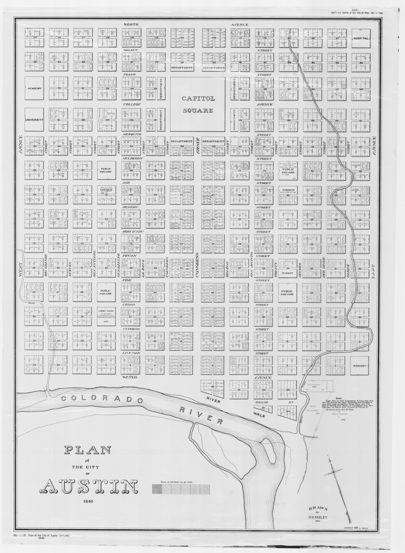
Plan of the City of Austin
[Austin Inlots]
RG-1-18
-
Map/Doc
2179
-
Collection
General Map Collection
-
Object Dates
1840 (Creation Date)
1931 (Copy/Tracing Date)
-
People and Organizations
H.H. Farley (Draftsman)
-
Counties
Travis
-
Subjects
City
-
Height x Width
57.3 x 42.0 inches
145.5 x 106.7 cm
-
Medium
mylar
-
Scale
140 feet
-
Comments
Copied from the original in 1931 by Boggs.
See maps 2176, 4840, and 4837 for additional copies.
Related maps
Plan of the City of Austin

Print $40.00
- Digital $50.00
Plan of the City of Austin
1840
Size 54.0 x 38.9 inches
Map/Doc 2176
A Topographical Map of the Government Tract Adjoining the City of Austin

Print $20.00
- Digital $50.00
A Topographical Map of the Government Tract Adjoining the City of Austin
1840
Size 40.7 x 36.1 inches
Map/Doc 2177
A Topographical Map of the Government Tract Adjoining the City of Austin

Print $20.00
- Digital $50.00
A Topographical Map of the Government Tract Adjoining the City of Austin
1840
Size 44.1 x 38.4 inches
Map/Doc 2178
Topographical Map of the City of Austin

Print $20.00
- Digital $50.00
Topographical Map of the City of Austin
1887
Size 43.1 x 41.1 inches
Map/Doc 2189
City of Austin and Vicinity

Print $20.00
- Digital $50.00
City of Austin and Vicinity
1839
Size 20.4 x 19.6 inches
Map/Doc 3149
[Map of the City of Austin]
![4802, [Map of the City of Austin], General Map Collection](https://historictexasmaps.com/wmedia_w700/maps/4802-1.tif.jpg)
Print $20.00
- Digital $50.00
[Map of the City of Austin]
1856
Size 29.1 x 21.5 inches
Map/Doc 4802
A Topographical Map of the City of Austin

Print $20.00
- Digital $50.00
A Topographical Map of the City of Austin
1872
Size 21.0 x 14.7 inches
Map/Doc 4821
A Topographical Map of the Government Tract Adjoining the City of Austin

Print $20.00
- Digital $50.00
A Topographical Map of the Government Tract Adjoining the City of Austin
1840
Size 41.8 x 37.5 inches
Map/Doc 4833
Plan of the City of Austin

Print $40.00
- Digital $50.00
Plan of the City of Austin
1840
Size 56.2 x 42.0 inches
Map/Doc 4837
Plan of the City of Austin

Print $40.00
- Digital $50.00
Plan of the City of Austin
1840
Size 55.5 x 38.9 inches
Map/Doc 4840
A Topographical Map of the Government Tract Adjoining the City of Austin

Print $20.00
- Digital $50.00
A Topographical Map of the Government Tract Adjoining the City of Austin
1840
Size 41.9 x 37.4 inches
Map/Doc 4842
Plan of the City of Austin

Print $20.00
Plan of the City of Austin
1839
Size 24.2 x 19.4 inches
Map/Doc 76204
Plan of the City of Austin

Print $20.00
Plan of the City of Austin
1853
Size 13.9 x 11.5 inches
Map/Doc 76207
A Topographical Map of The Government Tract Adjoining the City of Austin

Print $20.00
- Digital $50.00
A Topographical Map of The Government Tract Adjoining the City of Austin
1840
Size 44.5 x 36.0 inches
Map/Doc 82031
Part of: General Map Collection
Duval County Working Sketch 56

Print $20.00
- Digital $50.00
Duval County Working Sketch 56
1989
Size 26.7 x 27.2 inches
Map/Doc 68780
Webb County Working Sketch 82

Print $40.00
- Digital $50.00
Webb County Working Sketch 82
1979
Size 32.9 x 62.9 inches
Map/Doc 72449
Houston County Sketch File 30

Print $4.00
- Digital $50.00
Houston County Sketch File 30
1895
Size 8.3 x 7.1 inches
Map/Doc 26806
Flight Mission No. CUG-3P, Frame 143, Kleberg County

Print $20.00
- Digital $50.00
Flight Mission No. CUG-3P, Frame 143, Kleberg County
1956
Size 19.0 x 22.5 inches
Map/Doc 86278
San Luis Pass to East Matagorda Bay

Print $20.00
- Digital $50.00
San Luis Pass to East Matagorda Bay
1976
Size 35.1 x 46.7 inches
Map/Doc 69969

Coast Chart No. 210 - Aransas Pass and Corpus Christi Bay with the coast to latitude 27° 12', Texas

Print $20.00
- Digital $50.00
Coast Chart No. 210 - Aransas Pass and Corpus Christi Bay with the coast to latitude 27° 12', Texas
1887
Size 23.4 x 29.4 inches
Map/Doc 73443
Grayson County Working Sketch 17

Print $20.00
- Digital $50.00
Grayson County Working Sketch 17
1955
Size 16.0 x 42.5 inches
Map/Doc 63256
Brooks County Boundary File 2

Print $8.00
- Digital $50.00
Brooks County Boundary File 2
Size 8.6 x 11.3 inches
Map/Doc 50839
Kendall County Working Sketch 6

Print $20.00
- Digital $50.00
Kendall County Working Sketch 6
1947
Size 42.6 x 24.8 inches
Map/Doc 66678
Reagan County Working Sketch 5

Print $20.00
- Digital $50.00
Reagan County Working Sketch 5
1924
Size 19.2 x 19.5 inches
Map/Doc 71845
Montgomery County Rolled Sketch 10

Print $20.00
- Digital $50.00
Montgomery County Rolled Sketch 10
1905
Size 35.5 x 26.2 inches
Map/Doc 6796
You may also like
McLennan County Working Sketch 2

Print $20.00
- Digital $50.00
McLennan County Working Sketch 2
1941
Size 21.8 x 30.0 inches
Map/Doc 70695
Pecos County Rolled Sketch DK4

Print $20.00
- Digital $50.00
Pecos County Rolled Sketch DK4
Size 41.2 x 30.2 inches
Map/Doc 7309
Right of Way & Track Map San Antonio & Aransas Pass Railway Co.

Print $40.00
- Digital $50.00
Right of Way & Track Map San Antonio & Aransas Pass Railway Co.
1919
Size 25.8 x 57.1 inches
Map/Doc 64027
Harris County Historic Topographic 9

Print $20.00
- Digital $50.00
Harris County Historic Topographic 9
1916
Size 14.6 x 24.0 inches
Map/Doc 65819
Kent County Working Sketch 8

Print $20.00
- Digital $50.00
Kent County Working Sketch 8
1952
Size 27.2 x 37.1 inches
Map/Doc 70015
Crane County Rolled Sketch 24

Print $40.00
- Digital $50.00
Crane County Rolled Sketch 24
2002
Size 33.5 x 62.0 inches
Map/Doc 76427
Map of Parker County

Print $20.00
- Digital $50.00
Map of Parker County
1871
Size 20.1 x 17.0 inches
Map/Doc 3944
Calhoun County NRC Article 33.136 Sketch 15

Print $46.00
Calhoun County NRC Article 33.136 Sketch 15
2025
Map/Doc 97428
Map of Polk Co.

Print $40.00
- Digital $50.00
Map of Polk Co.
1906
Size 52.0 x 43.0 inches
Map/Doc 16789
Jim Hogg County Rolled Sketch 2

Print $20.00
- Digital $50.00
Jim Hogg County Rolled Sketch 2
Size 27.9 x 32.7 inches
Map/Doc 6438
Travis County Working Sketch 28

Print $20.00
- Digital $50.00
Travis County Working Sketch 28
1955
Size 31.5 x 30.7 inches
Map/Doc 69412
Flight Mission No. DQN-6K, Frame 3, Calhoun County

Print $20.00
- Digital $50.00
Flight Mission No. DQN-6K, Frame 3, Calhoun County
1953
Size 18.3 x 22.1 inches
Map/Doc 84425